| |
Latest
processed quarterly map
(click to enlarge)
Other
NE Pacific Seismicity:
|
|
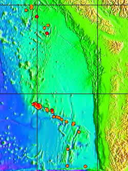
Earthquake
location maps for the NE Pacific have been accumulated since
August 29, 1991. The source location fixes are based on bearing
and arrival time information at 3 to 11 SOSUS hydrophone sites.
Source levels are estimated from received amplitudes and a
simple transmission loss model.
Recent
activity:
Gorda-Blanco-Southern
Juan de Fuca, July 2007
Gorda
Ridge, NE Pacific, March 2005
Endeavour
Ridge, NE Pacific, February 2005 Endeavour Ridge, October 2004
Cobb Offset, May 2004
West Valley, July 2003
Maps:
Earthquake
data files:
Earthquake
locations for the NE Pacific are currently being processed
from archived data and made available as each quarter is completed.
The data is monitored in real-time for any current seismic
events.
|
|