USGS Home - www.usgs.gov

Navassa Island: A Photographic Tour

Navassa Island Home
Explore Navassa
take a Tour:
geology | biology | history
or Explore:
fly | sail | hike | scuba
Navassa mapLulu BaySouth PointEast PointLighthouseThe InteriorEast CoastNortheast PointNorth Coast
Navassa Location Map
Explore Navassa - Hike
Exploring the Island - 61 photos
  begin

  hiking Navassa
hiking Navassa
 
Acres of poisonwood and moonscape-like karst surfaces are only a few of the hazards to those who explore the island on foot. There are so many solution caves on Navassa that water runs through the island like a sieve, leaving no surface water for the thirsty hiker. Nevertheless, a trek with care and a gallon of water will reward the hiker with some breathtaking views and historic sites.

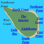
The hike starts off at the dock in Lulu Bay and heads inland to the Lighthouse. From there it continues out through the Interior of the island to the North Coast, then on around the perimenter of the island, and finishes with a climb down the cliff face at South Point to enter Don's Cave.


Hike Locations: The locations covered by the hike are shown below.
photographic map of Navassa Island

Hike - Photo Index
Lulu Bay
    bricks
    mining ruins
    railroad bed
    rusted boiler
    boiler & cistern
    royal pointciana
    wooden oars
    boobies
Lighthouse
    railroad
    lighthouse
    lighthouse
    fishermen
    researchers
    pump
    staircase
    top floor
    light pedestal
    keeper's house
    northeast view
    northeast view
    northwest view
    recent fire
    dog
    fossil coral
The Interior
    mining mound
    oolites
    phosphorite
    fractured rock
    solution crack
    rock samples
    speleothems
    fossil coral
    fossil coral
    fossil coral
    cave entrance
    climbing down
North Coast
    upper terrace
Northeast Point
    vertical cave
East Coast
    cactus
    terrace karst
    terrace karst
    terrace karst
    chopper wreck
    pseudopheonix
    lighthouse
    phosphate sand
    solution hole
East Point
    tree
    boulders
    boulders
    sea cliffs
    sea cliffs
    terrace slope
    lower terrace
South Point
    down the cliff
    cave entrance
    in the cave
    cave wall
    cave water
    cave pool
    railroad bed

Coastal and Marine Geology Program > Center for Coastal Geology > Navassa Island > Hike

U.S. Department of the Interior, U.S. Geological Survey, Coastal and Marine Geology Program
http://coastal.er.usgs.gov /navassa/hike/index.html
Maintaned by Trent Faust - Webmaster
Updated August 19, 2000 @ 04:27 PM (THF)