2000 Regional Analyses Products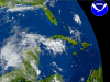
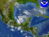
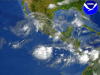
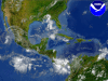
| Caribbean regional imagery, 2000.6.6 at 1413Z.
Latitude:
Longitude:
Data Elements: Imagery is from DMSP F-14.
Observation Device: DMSP F-14 2.7-km, visible imagery.
View our larger 1280 X 960
picture! |
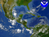
| Caribbean regional imagery, 2000.6.7 at 1015Z.
Latitude:
Longitude:
Data Elements: Imagery is from GOES East.
Observation Device: GOES East 4-km, infrared imagery.
View our larger 1280 X 960
picture! |
| Caribbean regional imagery 2000.6.7, at 1530Z.
Latitude:
Longitude:
Data Elements: Imagery is from DMSP F-14.
Observation Device: DMSP F-14 2.7km, visible imagery.
View our larger 1280 X 960
picture! |
| Caribbean regional imagery 2000.6.8, at 1615Z.
Latitude:
Longitude:
Data Elements: Imagery is from GOES East.
Observation Device: GOES East 4-km, infrared imagery.
View our larger 1280 X 960
picture! |
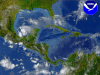
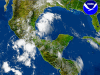
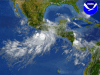
| Caribbean regional imagery, 2000.6.8 at 1815Z.
Latitude:
Longitude:
Data Elements: Close-up of an unnamed tropical depression at 21.0N 93.5W. Winds are sustained
at 25 kts, gusting to 35 kts.
Observation Device: GOES East 4-km, infrared imagery.
View our larger 1280 X 960
picture! |
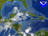
| Caribbean regional imagery 2000.6.9, at 1145Z.
Latitude:
Longitude:
Data Elements: Imagery is from GOES East.
Observation Device: GOES East 4-km, infrared imagery.
View our larger 1280 X 960
picture! |
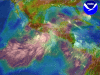
| Caribbean regional imagery 2000.6.9, at 1635Z.
Latitude:
Longitude:
Data Elements: Imagery shows close-up of the remnants from Tropical Depression 01 in the Gulf of Mexico.
Observation Device: DMSP F-14 2.7km, visible imagery.
View our larger 1280 X 960
picture! |
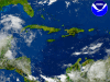
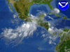
| Caribbean regional imagery 2000.6.13, at 1433Z.
Latitude:
Longitude:
Data Elements: Imagery is from DMSP F-14.
Observation Device: DMSP F-14 2.7km, visible imagery.
View our larger 1280 X 960
picture! |
| Caribbean regional imagery, 2000.6.14 at 1145Z with windarrows.
Latitude:
Longitude:
Data Elements: Imagery is from GOES East. Fused data is from Aviation prediction model run on
2000.6.14 at 0000Z. Streamlines show wind direction at 500 mb.
Observation Device: GOES East 4-km, infrared imagery. AVN model output.
View our larger 1280 X 960
picture! |
| Caribbean regional imagery, 2000.6.14 at 1145Z with relative humidity.
Latitude:
Longitude:
Data Elements: Imagery is from GOES East. Fused data is from Aviation prediction model run on
2000.6.14 at 0000Z. RH overlay is at P = 700 mb. Red zones indicate >= 90% RH
and show areas of probable precipitation. Blues zones show RH = 40%.
Observation Device: GOES East 4-km, infrared imagery. AVN model output.
View our larger 1280 X 960
picture! |

| Caribbean regional imagery, 2000.6.14 at 1145Z.
Latitude:
Longitude:
Data Elements: Imagery is from GOES East.
Observation Device: GOES East 4-km, infrared imagery.
View our larger 1280 X 960
picture! |
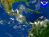
| Western Caribbean regional analysis, 2000.6.15 at 1200Z.
Latitude:
Longitude:
Data Elements: Imagery is from GOES West.
Observation Device: GOES West 4-km, infrared imagery.
View our larger 1280 X 960
picture! |
| Caribbean regional imagery, 2000.6.15 at 1200Z with relative humidity.
Latitude:
Longitude:
Data Elements: Imagery is from GOES West. Fused data is from Aviation prediction model run on
2000.6.15 at 0000Z. RH overlay is at P = 700 mb. Red zones indicate >= 90% RH
and show areas of probable precipitation. Blues zones show RH = 40%.
Observation Device: GOES West 4-km, infrared imagery. AVN model output.
View our larger 1280 X 960
picture! |
| Caribbean regional imagery, 2000.6.15 at 1745Z.
Latitude:
Longitude:
Data Elements: Imagery is from GOES East.
Observation Device: GOES East 4-km, infrared imagery.
View our larger 1280 X 960
picture! |
| Caribbean regional imagery 2000.6.19, at 1745Z.
Latitude:
Longitude:
Data Elements: Imagery is from GOES East.
Observation Device: GOES East 4-km, infrared imagery.
View our larger 1280 X 960
picture! |
| Caribbean regional imagery 2000.6.19, at 1745Z.
Latitude:
Longitude:
Data Elements: Imagery is from GOES East. Fused data is from Aviation prediction model run on
2000.6.19 at 0000Z. RH overlay is at P = 700 mb. Red zones indicate >= 90% RH
and show areas of probable precipitation. Blues zones show RH = 40%.
Observation Device: GOES East 4-km, infrared imagery. AVN model output.
View our larger 1280 X 960
picture! |
| Caribbean regional imagery 2000.6.19, at 1745Z with windarrows.
Latitude:
Longitude:
Data Elements: Imagery is from GOES East. Fused data is from Aviation prediction model run on
2000.6.19 at 0000Z. Streamlines show wind direction at 500 mb.
Observation Device: GOES East 4-km, infrared imagery. AVN model output.
View our larger 1280 X 960
picture! |