| NOAA Magazine || NOAA Home Page || Fact Sheet |
NOAA
REVIEWS RECORD-SETTING 2005 ATLANTIC HURRICANE SEASON
Active Hurricane Era Likely To Continue
[Editor’s Note: This story was updated April 13, 2006, to reflect
the final totals for the 2005 Atlantic hurricane season.]
 Nov.
29, 2005 (Updated April 13, 2006) � The 2005 Atlantic
hurricane season is the busiest on record and extends the active hurricane
cycle that began in 1995—a trend likely to continue for years
to come. The season included 28 named storms, including 15 hurricanes
in which seven were major (Category 3 or higher). (Click NOAA
image for larger view of the records set during the 2005 Atlantic hurricane
season. Please credit “NOAA.”) [News Conference
photos]
| News
Conf. Audio (mp3) |
|
| Conrad C. Lautenbacher, Jr. (opening statement) 5:41 | |
| David L. Johnson (opening statement) 4:45 | |
| Dr. Gerry Bell (opening statement) 8:43 | |
| Max Mayfield (opening statement) 3:52 | |
| Q & A 21:38 | |
| Podcast 5:05 | Podcast 3:49 |
“This hurricane season shattered records that have stood for decades—most named storms, most hurricanes and most category five storms. Arguably, it was the most devastating hurricane season the country has experienced in modern times,” said retired Navy Vice Adm. Conrad C. Lautenbacher, Jr., Ph.D., undersecretary of commerce for oceans and atmosphere and NOAA administrator. “I’d like to foretell that next year will be calmer, but I can’t. Historical trends say the atmosphere patterns and water temperatures are likely to force another active season upon us.”
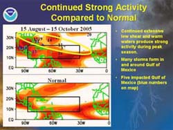
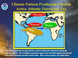
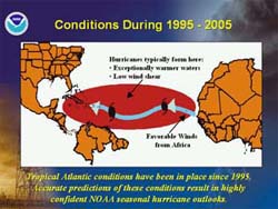
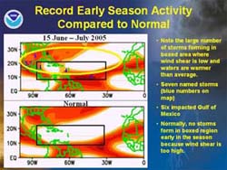
The Atlantic Basin is in the active phase of a multi-decadal cycle in which optimal conditions in the ocean
and atmosphere, including warmer-than-average sea-
Records
set this season include the totals for: |
| *
Named storms: 28; previous record: 21 in 1933 * Hurricanes: 15; previous record: 12 in 1969 * Major hurricanes hitting the U.S.: Four (Dennis, Katrina, Rita and Wilma); previous record: Three, most recently in 2004 * Hurricanes of Category 5 intensity (greater than 155 mph): Four (Emily, Katrina, Rita and Wilma); previous record: Two in 1960 and 1961 |
surface temperatures and low wind shear, enhance hurricane activity. This increase in the number and intensity of tropical storms and hurricanes can span multiple decades (approximately 20 to 30 years). NOAA will make its official 2006 season forecast in May, prior to the June 1st start to the season.
"Evidence of this active cycle was demonstrated this year as the Atlantic Basin produced the equivalent of more than two entire hurricane seasons over the course of one. Because we are in an active hurricane era, it's important to recognize that with a greater number of hurricanes comes increasing odds of one striking land," said retired Air Force Brig. Gen. David L. Johnson, director of the NOAA National Weather Service.
NOAA scientists
predicted this would be an extremely active hurricane season, forecasting
near-record activity in early August. The 28 named storms topped the
forecast range of 18 to 21, the 15 hurricanes inched above the forecast
of nine to 11 and the seven major hurricanes fell within NOAA's forecast
range of five to seven. Six hurricanes (Cindy, Dennis, Katrina, Ophelia,
Rita and Wilma) and two tropical storms (Arlene and Tammy) directly
impacted the 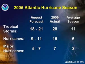 U.S.
(Click NOAA image for larger view of the storm totals for the
2005 Atlantic hurricane season. Please credit “NOAA.”)
Letters of the Greek alphabet were used to name storms for the first time since storms began acquiring names in 1953, as Hurricane Wilma exhausted the original list of 21 names. Tropical Storm Alpha and Hurricane Beta hit the Dominican Republic and Nicaragua, respectively. Tropical Storm Gamma brought deadly flooding to parts of Central America. Tropical Storm Delta largely stayed over open water then moved across the Canary Islands off the northwest coast of Africa. Tropical Storm Epsilon formed on the next to last day of the Atlantic hurricane season over the central Atlantic Ocean. Tropical Storm Zeta formed on December 30 and dissipated in early January 2006.
 With
six months until the official start of the 2006 Atlantic hurricane season,
NOAA urges hurricane-prone residents to take proactive measures during
this time. "The battle against the hurricane season is won during
the off season. Winter and spring is the time to conduct hurricane preparations,
such as stocking supplies, assembling a safety kit that includes a NOAA
Weather Radio and preparing an evacuation plan," said Max Mayfield,
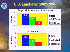
director of the NOAA National Hurricane Center. (Click NOAA
image for larger view of the number of U.S. landfalling tropical storms
and hurricanes from 2002 to 2005. Please credit “NOAA.”)
"Amid this period of more numerous and more intense hurricanes, NOAA is focused on our mission of serving society's needs for weather information and supporting the nation's commerce," said Lautenbacher. "NOAA is there to provide accurate storm forecasts and also stays engaged after the storm to ensure safe commercial fishing and continued navigation of our nation's impacted waterways."
The NOAA National Weather Service is the primary source of weather data, forecasts and warnings for the United States and its territories. The NOAA National Weather Service operates the most advanced weather and flood warning and forecast system in the world, helping to protect lives and property and enhance the national economy.
NOAA, an
agency of the U.S. Department of
Commerce, is dedicated to enhancing economic security and national
safety through the prediction and research of weather and climate-related
events and providing environmental stewardship of the nation's coastal
and marine resources.
Through the emerging Global Earth Observation System of Systems (GEOSS),
NOAA is working with its federal partners and nearly 60 countries to
develop a global monitoring network that is as integrated as the planet
it observes.
Relevant Web Sites
Noteworthy Records of the 2005 Atlantic Hurricane
Season
NOAA Attributes
Recent Increase in Hurricane Activity to Naturally Occurring Multi-decadal
Climate Variability
NOAA 2005 Atlantic Hurricane Outlook
NOAA Atlantic Hurricane Outlook and Summary Archive
NOAA National Hurricane Center
NOAA Climate Prediction Center
2004 Atlantic Hurricane Season
NOAA 2005 Satellite Images (NOAA Environmental Visualization Lab)
NOAA 2005 Satellite Images (Operational of Significant Event Imagery, or OSEI)
Media
Contact:
Chris Vaccaro, NOAA
National Weather Service, (301) 713-0622 ext. 134
