| NOAA Magazine || NOAA Home Page |
 March
21, 2006 — Most people are familiar with NOAA’s
use of unmanned or autonomous underwater vehicles, but NOAA is also interested
in routinely using unmanned aircraft systems
to explore and gather data in the atmosphere between satellite
and ground-based observing systems. UAS-acquired data will supplement
data gathered by current “suborbital” airborne platforms —
aircraft, sounding rockets, airships and balloons — and complement
existing surface-based and space-based observing systems. (Click
NOAA image for larger view of Retired Navy Vice Adm. Conrad Lautenbacher,
Ph.D., undersecretary of commerce for oceans and atmosphere and NOAA administrator,
giving a briefing in front of the Altair unmanned aircraft system, or
UAS. Click here for high resolution
version, which is a large file. Please credit “NOAA.”)
March
21, 2006 — Most people are familiar with NOAA’s
use of unmanned or autonomous underwater vehicles, but NOAA is also interested
in routinely using unmanned aircraft systems
to explore and gather data in the atmosphere between satellite
and ground-based observing systems. UAS-acquired data will supplement
data gathered by current “suborbital” airborne platforms —
aircraft, sounding rockets, airships and balloons — and complement
existing surface-based and space-based observing systems. (Click
NOAA image for larger view of Retired Navy Vice Adm. Conrad Lautenbacher,
Ph.D., undersecretary of commerce for oceans and atmosphere and NOAA administrator,
giving a briefing in front of the Altair unmanned aircraft system, or
UAS. Click here for high resolution
version, which is a large file. Please credit “NOAA.”)
 NOAA
has completed several successful UAS demonstration projects and plans
more in the near future. “The success of these projects show that
the nation’s ability to understand and predict the world we live
in is reaching new heights," said retired Navy Vice Adm. Conrad
Lautenbacher, Ph.D., undersecretary of commerce for oceans and atmosphere
and NOAA administrator. "UAS fill in a critical gap where land- and
satellite-based observations sometimes fall short, giving us a view of
the planet never before seen. NOAA’s use of UAS represents a huge
step forward for Earth sciences that could greatly help NOAA achieve its
mission goals to conserve
and manage coastal and marine resources to meet our nation's economic,
social and environmental needs." (Click NOAA image for larger
view of the Altair unmanned aircraft system in flight.
Click here for high resolution
version, which is a large file. Please credit “NOAA.”)
NOAA
has completed several successful UAS demonstration projects and plans
more in the near future. “The success of these projects show that
the nation’s ability to understand and predict the world we live
in is reaching new heights," said retired Navy Vice Adm. Conrad
Lautenbacher, Ph.D., undersecretary of commerce for oceans and atmosphere
and NOAA administrator. "UAS fill in a critical gap where land- and
satellite-based observations sometimes fall short, giving us a view of
the planet never before seen. NOAA’s use of UAS represents a huge
step forward for Earth sciences that could greatly help NOAA achieve its
mission goals to conserve
and manage coastal and marine resources to meet our nation's economic,
social and environmental needs." (Click NOAA image for larger
view of the Altair unmanned aircraft system in flight.
Click here for high resolution
version, which is a large file. Please credit “NOAA.”)
Areas of NOAA that could benefit from the use of UAS include: climate change, weather, ocean and atmospheric research, water resource management, monitoring and evaluation of important ecosystems (including sanctuaries) and endangered species, shoreline mapping/nautical charting, satellite calibration and verification and surveillance for homeland security, fisheries and marine sanctuaries monitoring and enforcement.
 UAS
allow NOAA to carry instruments to remote locations that could not otherwise
be reached with conventionally piloted aircraft and conduct missions that
would otherwise be too dangerous or impractical for manned flight. UAS
are often described as the best choice for “dirty, dull, and dangerous
missions” — dirty because they can be sent to contaminated
areas; dull because they allow for long transit times, opening new dimensions
of persistent surveillance and tracking; and dangerous because they can
go into hazardous areas with no threat to human life. (Click NOAA
image for larger view of image showing how unmanned aircraft are an important
contribution to the emerging Global Earth Observing System of Systems.
Please credit “NOAA.”)
UAS
allow NOAA to carry instruments to remote locations that could not otherwise
be reached with conventionally piloted aircraft and conduct missions that
would otherwise be too dangerous or impractical for manned flight. UAS
are often described as the best choice for “dirty, dull, and dangerous
missions” — dirty because they can be sent to contaminated
areas; dull because they allow for long transit times, opening new dimensions
of persistent surveillance and tracking; and dangerous because they can
go into hazardous areas with no threat to human life. (Click NOAA
image for larger view of image showing how unmanned aircraft are an important
contribution to the emerging Global Earth Observing System of Systems.
Please credit “NOAA.”)
UAS could also contribute data toward the comprehensive Global Earth Observing System of Systems (GEOSS) being developed by more than 60 countries. "We must move new but proven observing systems into an operational environment and redirect associated resources and research toward exploring new technologies, such as unmanned aerial vehicles, to meet future requirements,” said Lautenbacher.
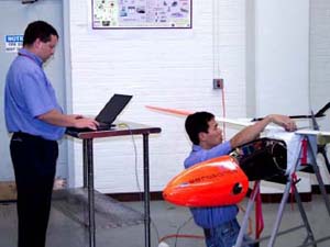
 Unmanned
Aircraft Systems In General
Unmanned
Aircraft Systems In General
UAS are powered aerial systems that do not carry a pilot or fly
according to traditional aerodynamic forces, but are independently or
remotely piloted. They can be land-, air-, or ship-launched; and can carry
an internal or external payload of scientific equipment. The system typically
consists of the aerial vehicle itself, a ground flight control station
or cockpit, ground data retrieval and processing stations (including satellite
communications link) and sometimes, the wheeled land-based vehicles that
carry launch and recovery platforms. (Click NOAA image for larger
view of pilot sitting at a console flying the Altair unmanned aircraft
system, or UAS. Click here for
high resolution version, which is a large file. Please credit “NOAA.”)
There are many different types of UAS. They may have a wingspan as large
as a Boeing 737 (93 to 112 feet) or be as small as a radio-controlled
model airplane (one foot). They can carry as little as a pound or as much
as 3,000 pounds of equipment. Flight endurance ranges from less than an
hour to more than 30 hours. Maximum speeds range from approximately 23
miles per hour to greater than 400 miles per hour. Most commercially produced
aircraft have a maximum altitude ceiling of approximately 40,000 feet,
but UAS can go much higher (one type of UAS currently in production can
reach an altitude of approximately 65,000 feet). UAS can either be remotely
controlled from the ground by an operator or preprogrammed to conduct
an entire flight without intervention. Because no human pilot is actually
onboard, UAS must get information about the external environment through
electronic sensors. The input from the sensors is either processed onboard
— so the aircraft’s computers can evaluate and monitor the
flight environment and forward the data to the pilot-in-command controlling
the plane — or processed on the ground.
UAS are a
new, developing segment of the aviation industry. Although they have been
widely used by the military and intelligence agencies overseas in recent
years, civilian agencies like NOAA are only beginning to test them. NOAA
and NASA have been mandated by Congress to organize a plan to bring UAS
technology into their future atmospheric science programs. On March 17,
2006, NOAA delivered a report to Congress on the potential use of UAS
to operate in the near space environment for a variety of scientific and
operational missions.
NOAA Unmanned
Aircraft System Demonstration Projects
NOAA
has completed four NOAA
UAS demonstration projects. The first two projects were joint NOAA/NASA
UAS missions conducted in 2005 — an Altair
UAS demonstration project using a variety of NOAA instruments on the
west coast to achieve science and operations goals and an Aerosonde
UAS flight into Tropical
Storm Ophelia to obtain critical, previously unobtainable hurricane
data. In 2006, NOAA conducted a third UAS demonstration project using
a Silver Fox UAS in Hawaii
to observe shallow subsurface, living marine resources and vessels, and
supported a fourth project using the Manta
UAS to study air quality in the Indian Ocean.
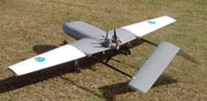
 Altair
UAS Demonstration Project
Altair
UAS Demonstration Project
The
Altair
demonstration project ran from April to November 2005 off the west
coast of California and Oregon. The project included researchers from
the NOAA Earth System Research Laboratory,
NOAA Ocean Service and NASA’s
Dryden Flight Research Center (at the Edwards Air Force Base in Calif.),
as well as General Atomics
Aeronautical Systems, Inc. (San Diego, Calif.), which built and operated
the Altair. Altair is a high altitude, long endurance UAS built initially
to support NASA’s Earth science research needs. With a wingspan
of 86 feet, it can carry an internal 660 pound payload of sensors and
other scientific equipment to approximately 52,000 feet for more than
30 hours. The Altair operational payload was chosen to demonstrate mapping,
monitoring and surveillance capabilities and included remote and in
situ instruments for measuring ocean color, atmospheric composition
and temperature; as well a as surface imaging and surveillance system.
(Click NOAA image for larger view of Altair unmanned aircraft
system, or UAS. Click here for high
resolution version, which is a large file. Please credit “NOAA.”)
 The
ALTAIR UAS completed five flights for this demonstration project, totaling
more than 45 flight hours and reached altitudes as high as 45,000 feet.
Flights over the Pacific Ocean demonstrated the potential of an UAS to
fly missions longer than 18 hours to remote areas. Flights over the Channel
Islands National Marine Sanctuary, demonstrated the surveillance capabilities
of the platform and its ability to perform coastal remote sensing missions.
(Click NOAA image for larger view of Altair instrument payload.
Please credit “NOAA.”)
The
ALTAIR UAS completed five flights for this demonstration project, totaling
more than 45 flight hours and reached altitudes as high as 45,000 feet.
Flights over the Pacific Ocean demonstrated the potential of an UAS to
fly missions longer than 18 hours to remote areas. Flights over the Channel
Islands National Marine Sanctuary, demonstrated the surveillance capabilities
of the platform and its ability to perform coastal remote sensing missions.
(Click NOAA image for larger view of Altair instrument payload.
Please credit “NOAA.”)
Aerosonde
UAS Demonstration Project
NOAA’s
second UAS demonstration occurred on Sept. 16, 2005, when hurricane researchers
from the NOAA Atlantic Oceanographic
and Meteorological Laboratory in Miami, Fla., used a smaller five
foot, 33-pound, Aerosonde
to demonstrate the potential benefit of using an UAS to obtain critical,
previously unsampled and unobtainable hurricane data. NOAA’s partners
in this effort included Aerosonde, Inc., the system’s designer and
operator, and NASA Goddard’s
Wallops Flight Facility in Wallops Island, Va., which houses the U.S.
base for Aerosonde North
America and served as the departure and landing location for this
historic flight.
 While
the successful use of piloted hurricane
hunter aircraft (i.e., NOAA
WP-3D Orion and Gulfstream-IV
aircraft, as well as the U.S. Air Force Reserve's WC-130H
& J aircraft) has been an important tool for understanding hurricanes,
detailed observations of the near- sea surface hurricane environment have
been elusive because of the severe safety risks associated with these
low-level manned missions. The main objective of the Aerosonde project
was to address this significant observational shortcoming by using the
unique long endurance, low-flying attributes of the unmanned Aerosonde.
While
the successful use of piloted hurricane
hunter aircraft (i.e., NOAA
WP-3D Orion and Gulfstream-IV
aircraft, as well as the U.S. Air Force Reserve's WC-130H
& J aircraft) has been an important tool for understanding hurricanes,
detailed observations of the near- sea surface hurricane environment have
been elusive because of the severe safety risks associated with these
low-level manned missions. The main objective of the Aerosonde project
was to address this significant observational shortcoming by using the
unique long endurance, low-flying attributes of the unmanned Aerosonde.
Tropical Storm Ophelia provided the perfect test case for using the Aerosonde (in conjunction with NOAA and Air Force hurricane hunter aircraft), since it had just been downgraded from a hurricane and it was within flight range of the Wallops Flight Facility on Virginia’s eastern shore. The Aerosonde that ventured into Ophelia relayed real time temperature, pressure, humidity and wind speed information through a satellite communications link to ground users. The Aerosonde also carried a downward positioned infrared sensor used to estimate the underlying sea surface temperature. All available data were transmitted in near-real time to the NOAA National Hurricane Center and AOML. This unique data could ultimately be used to help initialize and verify both operational- and research-oriented numerical simulations and lead to improved hurricane intensity and track forecasts. The ten-hour mission marked the first time an UAS had flown into a tropical storm and provided the first detailed observations of a tropical storm’s high wind environment near the sea surface, an area that is normally too dangerous for piloted aircraft to observe directly.
 The
environment where the atmosphere meets the sea is critically important
in hurricanes as it is where the ocean's warm water energy is directly
transferred to the atmosphere just above it and where the strongest winds
in a hurricane are found. It is also at a level where most citizens live.
Observing and ultimately better understanding this region of the storm
is crucial to improve forecasts of hurricane intensity and structure.
Enhancing this predictive capability would not only save the U.S. economy
billions of dollars, but more important, it could save many lives. (Click
image for larger view of the Aerosonde unmanned aerial vehicle being released
from its transport vehicle on the runway at the NASA Wallops flight Facility,
in Wallops Island, Va., to fly into and take measurements of Tropical
Storm Ophelia on Sept. 16, 2005. Click here
for high resolution version. Photo courtesy of NASA.)
The
environment where the atmosphere meets the sea is critically important
in hurricanes as it is where the ocean's warm water energy is directly
transferred to the atmosphere just above it and where the strongest winds
in a hurricane are found. It is also at a level where most citizens live.
Observing and ultimately better understanding this region of the storm
is crucial to improve forecasts of hurricane intensity and structure.
Enhancing this predictive capability would not only save the U.S. economy
billions of dollars, but more important, it could save many lives. (Click
image for larger view of the Aerosonde unmanned aerial vehicle being released
from its transport vehicle on the runway at the NASA Wallops flight Facility,
in Wallops Island, Va., to fly into and take measurements of Tropical
Storm Ophelia on Sept. 16, 2005. Click here
for high resolution version. Photo courtesy of NASA.)
“If we want to improve future forecasts of hurricane intensity change, we will need to get continuous low-level observations near the air-sea interface on a regular basis,” said Joe Cione, NOAA hurricane researcher at AOML and the lead scientist on this project. “But since manned flights near the surface of the ocean are risky — remote unmanned aircraft, such as the Aerosonde, are the only way to go."
 Silver
Fox UAS Demonstration Project
Silver
Fox UAS Demonstration Project
The
NOAA National Marine Sanctuary
Program and the NOAA National
Marine Fisheries Service conducted NOAA’s third UAS demonstration
project by flying a Silver Fox UAS in the airspace above the Hawaiian
Islands Humpback Whale National Marine Sanctuary off the island of
Kauai on Feb. 14 to 19, 2006. (Click image for larger view of
image showing the Silver Fox UAS used in NOAA's UAS demonstration
project in Hawaii. Click here
for high resolution version. Photo courtesy of NOAA.)
The Silver Fox is a small, low altitude, short endurance UAS that was developed with Office of Naval Research funding to function primarily as an "expendable over the horizon surveillance tool" that could be launched from ships and/or from land. This UAS can be operated for up to eight hours at altitudes up to 10,000 feet and can achieve air speed ranging from 40 to 63 miles per hour. It carries optical and infrared surveillance camera systems and sends real-time images to a command console on the ground. It is controlled via line of sight communication and has an effective operating range of 20 plus nautical miles. Advanced Ceramics Research in Tucson, Ariz., built the Silver Fox UAS.
The payload for the Silver Fox demonstration project included instruments for observing and counting shallow subsurface features, surface features, living resources and vessels. For example, an electro-optical infrared sensor was used to determine to what extent these operational needs could be met in future UAS flights. The EO/IR system was also used to assess its ability to conduct day and night fisheries surveillance and enforcement, and selected marine mammal surveys.
Non-NOAA UAS Projects Receiving NOAA Support
 Manta
UAS Demonstration Project
Manta
UAS Demonstration Project
NOAA's
Climate Program is supporting an UAS demonstration project based out of
Hanimaadhoo Island in the Maldives
in February and March of this year. A total of 16 flights are planned
for three Manta UAS, equipped with radiation and aerosol sensors, which
will fly in formation through cloudy and cloud-free air containing anthropogenic
influence from India.
The flights also coordinated with ground-based measurements made at the Maldives Climate Observatory on Hanimaadhoo Island. The objective of this project was to obtain new information about how aerosols and clouds regulate planetary albedo, with particular emphasis on indirect effects such as how anthropogenic aerosols change the albedo of cloudy skies. Veerabhadran Ramanathan, chief scientist with the Center for Clouds, Chemistry, and Climate at Scripps Institution of Oceanography (in La Jolla, Calif.) is leading the project along with a team of scientists and engineers from Scripps and personnel from the Maldives Climate Observatory. Personnel from NASA Dryden Flight Research Center also served as consultants for project planning and logistics. Funding was provided by NOAA, NASA and the National Science Foundation.
 Future
or Proposed UAS Projects
Future
or Proposed UAS Projects
NOAA
already has plans for several additional UAS missions in the near future,
including the following:
- The NOAA Pacific Marine Environment Laboratory is investigating the use of UAS to expand its aerosol sampling capabilities from sea.
- The NOAA Office of Response and Restoration is in the conceptual stage of developing plans for use of UAS during NOAA's Safe Seas emergency response drill in California later this year and R&R modeling efforts in the future. (Click NOAA image for larger view of researcher conducting preflight tests before flying the Altair unmanned aircraft system, or UAS. Click here for high resolution version, which is a large file. Please credit “NOAA.”)
NOAA is also interested in participating in a number of non-NOAA UAS projects including the following:
- NOAA Altair project personnel have been invited to give a “lessons learned” seminar for NASA Ames and the U.S. Forest Service personnel in preparation for their upcoming Western States Wildfire Mission (August 2006), during which they are planning a series of 20-hour operations over the Western United States to monitor and observe fires.
- NASA will conduct a series of flights beginning in FY2007 with an Altair or Predator UAS (General Atomics Aeronautical Systems) in support of validation of the NASA Aura satellite. Aura measures a wide variety of trace gases and aerosols in the troposphere and stratosphere. NOAA investigators will provide several of the instruments for the UAS.
 Challenges
Although
UAS present a unique opportunity to improve scientific research and expand
the nation’s observational capacity, they are, in general, not ready
for routine operational use. Current challenges include: increasing reliability
of platform control and communications; cost effectiveness when compared
to manned aircraft; liability; FAA regulatory issues to routinely operate
in the National Airspace and sensor development and integration of unmanned
aircraft. However, like radar and satellites, UAS still have the potential
to revolutionize how humans monitor the global environment in the near
future.
The
Future of UAS
NOAA
constantly seeks better and more cost effective ways of accomplishing
its mission for the nation. As demonstrated in the above article and in
the March 17 report to Congress, there are numerous possible NOAA missions
that could be accomplished with UAS. The emerging UAS technology has the
potential to complement NOAA’s current observational architecture.
However, integrating UAS into the NOAA mission and the national airspace
system has its challenges. NOAA continues to build upon its already successful
UAS demonstration projects and developing new partnerships as NOAA moves
forward in this new era of aviation.
Relevant
Web Sites
NOAA Unmanned
Aircraft Systems Page
Unmanned Aircraft Systems
Flight Demonstration Project 2005
"Return to Flight" of NOAA Unmanned Aircraft Systems Demonstration Aircraft
Silver Fox UAS Demonstration Project
Media
Contact:
Kent
Laborde, NOAA, (202) 482-5757