
Comparing the sizes of Antarctica and the United States.
High Resolution Download (tif, 872KB, 1280x720 pixels)
Antarctica can be conveniently divided into three regions. The 2000-kilometer Transantarctic Mountains are a rugged boundary separating the continent into a large sector in the eastern hemisphere, called East Antarctica, and a smaller sector in the western hemisphere, called West Antarctica. The Antarctic Peninsula is the farthest northward region of Antarctica and is primarily a second mountain range.
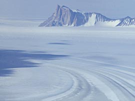
 The East Antarctic ice is typified by vast flat areas of polar desert, where it is too cold for much snow to fall, frigid winds blow continuously, and the landscape is nearly featureless. |
 The West Antarctic ice sheet rests on a bed well below sea level and is drained by much larger outlet glaciers and ice streams that accelerate over distances of hundreds of kilometers before reaching the ocean, often through large floating ice shelves. High Resolution Download (jpg, 1.7MB, 1962x1259 pixels) |

A vertical cross-section through Antarctica shows that the East Antarctic ice sheet is much higher than the West Antarctic ice sheet.

A typical view of the Antarctic Peninsula, where tall mountains rise receive large amounts of snow that form glaciers which flow back into the frigid coastal waters.
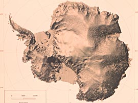 This shaded relief view of Antarctica emphasizes the irregular shape of the surface. Major regions are divided by smooth ridges. The large Ross and Ronne ice shelves are extremely flat. High Resolution Download (jpg, 1.1MB, 1460x1184 pixels) |
 The elevation of the ice sheet shows the higher dome of the East Antarctic ice sheet and the narrow connection between it and the West Antarctic ice sheet. High Resolution Download (jpg, 52KB, 410x391 pixels) |
 The elevation of the bed beneath the ice sheet shows rugged topography combining high mountain ranges with large areas well below sea level. High Resolution Download (jpg, 92KB, 652x643 pixels) |
 Snow pits dug into the surface snow (and back lit with a second pit to illuminate a thin wall of snow) show layers caused by individual snowfall events. Unevenness of the layers results from drifting of the snow while it was on the surface. High Resolution Download (jpg, 108KB, 750x563 pixels) |

Flow rates (shown in color) vary greatly from the slow interior to the rapidly moving edges. The slowest rates correspond to the ice divides between large catchment areas of the fastest flowing outlet glaciers. These divides and catchment areas can be seen in the shape of the ice sheet (compare with earlier figure).
High Resolution Download (tif, 1.1MB, 692x559 pixels)
 Snow falling on the surface does not stay on the surface, but takes a deeper journey through the ice sheet as it is buried by subsequent snow and is compressed into solid ice. Snow falling in the deepest interior parts of Antarctica can take over 100,000 years to reach the ocean. High Resolution Download (png, 188KB, 1403x1119 pixels) |
 Where ice flows very fast, it can fracture, creating crevasses. The crevasses can be thin, narrow cracks less than an inch wide, or gaping chasms tens of meters wide and kilometers long. Seemingly very deep, the weight of the ice generally prevent crevasses from extending more than 20 meters below the surface. High Resolution Download (jpg, 36KB, 395x209 pixels) |
 Two Antarctic scientists pictured in a near "white-out", a condition where light becomes so diffuse that there is no visible difference between the sky and the ground. In such conditions it is easy to become disoriented, to be unable to focus on either near or distant objects. Even walking becomes difficult. High Resolution Download (tif, 788KB, 599x448 pixels) |
 The ends of glaciers that reach the ocean usually break apart into icebergs. The size of icebergs can range from small ice-cube sized chunks to vast tabular icebergs many tens of kilometers on a side. High Resolution Download (jpg, 56KB, 640x480 pixels) |
Download the Fact Sheets

|

|
|
||
| A3_overview.pdf (624 kb) | A4_context.pdf (2.9 mb) |


