View 1
|

|
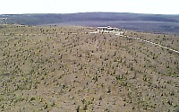
Lava flows spilled from Halema`uma`u pit crater (top left) from early 1800s to 1921 to build low shield on southwest caldera floor
|
View 2
|

|
Uwekahuna Bluff, highest point of Kilauea's summit and location of USGS's Hawaiian Volcano Observatory and Hawai`i Volcanoes National Park's Jaggar Museum
|
View 3
|
|
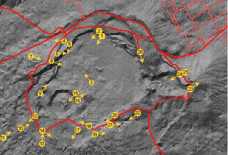
Lava flows and possible intrusion exposed in Uwekahuna Bluff in the west wall of Kilauea Caldera
|
View 4
|

|
Ecological zone of the upland forests and woodlands on the northwest side of Kilauea Caldera
|
View 5
|

|
Collapsed "blocks" along western caldera wall, and Halema`uma`u pit crater
|
View 6
|

|
Down-faulted blocks or landslide on caldera wall below northeast caldera rim
|
View 7
|
|
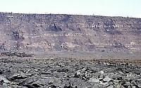
Hawaiian Volcano Observatory and the National Park Service's Jaggar Museum atop Uwekahuna Bluff; lava flows on gentle slope spilled from a shield that grew before the current caldera formed
|
View 8
|
|
Kilauea Iki (crater in top center) in front of `Aila`au shield on east side of caldera, and Mauna Ulu shield (right skyline) on east rift zone
|
View 9
|

|
Lava flows and explosive deposits exposed on steep southwest caldera wall
|
View 10
|

|
Aerial view of Halema`uma`u Crater and start of southwest rift zone within Kilauea Caldera
|
View 11
|

|
Aerial view of ground cracks and eruptive fissures along the uppermost southwest rift zone leading from Halema`uma`u; lava flow erupted in 1971
|
View 12
|

|
Crack and eruptive fissure along Kilauea's southwest rift zone adjacent to Crater Rim Drive
|
View 13
|

|
Aerial view of Halema`uma`u (upper right) and innermost caldera fault (left); dark lava flow erupted in 1974
|
View 14
|

|
Lava flow erupted in 1971 abuts the low southwest caldera wall, which is draped by the Keanakako`i Ash Member, erupted most recently in 1790 A.D., and overlying pumice deposit from about 1820
|