|
|
|
Metadata
|
|
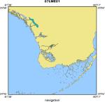
ID
|
07LME01
|
|
Also Known As
|
S-1-07-FL
|
|
Abstract
|
United States Geological Survey, St. Petersburg, Florida.
Chief Scientists: Tom Smith, Gordon Anderson, Karen
Balentine. Hydrographic data of field activity 07LME01
(S-1-07-FL) in Everglades National Park, Florida from
01/01/2007 to 12/31/2007
|
|
Organization
|
United States Geological Survey, St. Petersburg, Florida
|
|
Project/Theme
|
Dynamics of Land Margin Ecosystems
|
|
Chief Scientist
|
Tom Smith
Gordon Anderson
Karen Balentine
|
|
Activity Type
|
Hydrographic
|
|
Platform
|
SeaCraft
|
|
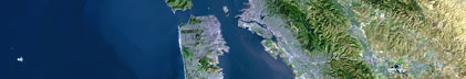
Area of Operation
|
Everglades National Park, Florida
|
|
Location map
|
|
|
Bounding Coordinates
|
25.92000
-81.56500 -80.34300
24.81000
|
|
Ports
|
LEAVE Everglades NP
ARRIVE Everglades NP
|
|
Dates
|
01/01/2007 (JD 001) to 12/31/2007 (JD 365)
|
|
Analog Materials
|
No analog holdings.
|
|
Index map

|
|
|
Information Specialist
|
|
|
Purpose
|
|
Characterize the surface and groundwater hydrology in the coastal Everglades
|
|
|
Information to be Derived
|
|
Surface-water stage, temperature and conductivity;
|
|
Ground-water level, temperature and conductivity;
|
|
Depth and duration of wetland flooding
|
|
|
Summary
|
|
This task of the project collects continuous hydrological data from a network
|
|
of 16 sites along several drainages in the coastal Everglades. Sites vary from
|
|
freshwater wetlands (in headwater areas) to mangrove forests in downstream,
|
|
tidal regions.
|
|
|
Notes
|
|
Platform(s) used: 19 ft. SeaCraft, 17 ft. Parker, Airboat, Helicopter (ENP)
|
|
External funding from the Jacksonville District, USACOE and in-kind support from NPS, Everglades NP. Terrestrial, Freshwater, and Marine Ecosystems
|
|
|
Got Help?
|
For 07LME01, we would appreciate any information on -- analog materials, contract, crew, days at sea, dive count, equipment used, funding, kms of navigation, national plan, NGDC Info, owner, project number, publications, scanned materials, seismic description, station count, station description, submersible, tabulated info.
|
|