Summary
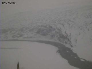
 *Image provided by Panya S. Lipovsky, Yukon Geological Survey. Canada’s Tweedsmuir Glacier is known to periodically surge, or undergo extended (1-2 year) periods of rapid advance. An ongoing surge began sometime before October 2007, but the exact timing is unknown. Observations by the University of Alaska, Fairbanks (Chris Larsen, personal communication) show that the surge has advanced the terminus at least 1250 m, and part of the terminus has entered the Alsek River.
Geologic evidence suggests that previous surges from Tweedsmuir and Lowell Glaciers have completely blocked the river, causing formation of a large lake. A flood from Tweedsmuir Lake would travel down the Alsek River to the Gulf of Alaska, passing near or through the community of Dry Bay, located at the mouth of the river.
*Movie provided by Jeff Conaway and Shad O'Neel,
US Geological Survey, Alaska Science Center.
The last known surge (1970s, Holdsworth, 1973) briefly blocked the river, but a major lake did not form, as the ice dam failed rapidly. The current surge appears more vigorous, but predicting the duration is not possible. However, it is common for surges to continue into and through winter. We know that disruption of meltwater delivery through the glacier plays an important role in surges, and recent observations describe abundant water high on the glacier (Chris Larsen, personal communication). This may indicate that the glacier’s plumbing system is still clogged, increasing the chances of continuation into winter. If the glacier advances another 50-100 m the river will become blocked.
To monitor glacier activity and potential lake formation, United States Geological Survey and National Park Service in cooperation with British Columbia Parks and University of Alaska Fairbanks, installed a timelapse camera to monitor the terminus geometry on August 22nd 2008. The camera transmits two images daily that help us monitor the surge, and evaluate downstream hazards.
The camera is pointed at what appeared to be the most active portion of the terminus at the time of the visit, although the minimum closure gap is just out of the frame to the left (downstream). From these images, we can determine if the glacier is thickening and advancing, and see any lake formation. The portion of the terminus that is thickening and advancing exceeds the capability of the camera. The overview shot above shows that a majority of the width of the glacier has advanced into the river, giving the current surge a higher probability of blocking the river.
More information is also available about the surge at the following phone numbers and locations:
The Tweedsmuir Hotline (maintained by the NPS) at 907-697-2695
National Weather Service Tweedsmuir Glacier Information
http://fairweather.gps.alaska.edu/chris
http://www.gi.alaska.edu/ScienceForum/ASF18/1878.html
USGS Real-Time Water Data for USGS 15129000 ALSEK R NR YAKUTAT AK
or by contacting USGS glaciology:
Shad O’Neel
907 786 7088
soneel@usgs.gov
| 

