
 Feeds & Data
M2.1 – San Francisco Bay Area, California
Sunday, January 11, 2009 at 16:59:44 UTC
Sunday, January 11, 2009 at 08:59:44 UTC-8
Sunday, January 11, 2009 at 08:59:44 UTC-8
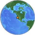
37.79°N 122.21°W
Depth: 9km


| Location | MMI | Resp. | Distance | Latitude | Longitude |
|---|---|---|---|---|---|
| HALF MOON BAY | 2 | 1 | 38 | 37.49°N | 122.41°W |
| REDWOOD CITY | 1 | 1 | 36 | 37.46°N | 122.24°W |
| SOUTH SAN FRANCISCO | 2 | 1 | 23 | 37.65°N | 122.42°W |
| SAN FRANCISCO | 1 | 1 | 17 | 37.80°N | 122.41°W |
| FREMONT | 3 | 1 | 38 | 37.50°N | 121.98°W |
| MORAGA | 2 | 1 | 9 | 37.83°N | 122.11°W |
| NAPA | 2 | 1 | 79 | 38.50°N | 122.27°W |
| OAKLAND | 2 | 1 | 1 | 37.80°N | 122.21°W |
| OAKLAND | 2 | 1 | 2 | 37.79°N | 122.24°W |
| OAKLAND | 2 | 3 | 6 | 37.83°N | 122.26°W |
| OAKLAND | 2 | 2 | 4 | 37.83°N | 122.22°W |
| OAKLAND | 2 | 2 | 5 | 37.81°N | 122.27°W |
| OAKLAND | 2 | 1 | 6 | 37.84°N | 122.24°W |
| OAKLAND | 2 | 1 | 3 | 37.79°N | 122.17°W |
| LOS GATOS | 2 | 1 | 74 | 37.15°N | 121.96°W |
- City mapJPG | PDF | PSMap of responses by city or ZIP code
- Intensity vs. DistanceJPG | PSPlot of Attenuation (fall-off) with distance for each intensity versus its distance from the epicenter
- Responses vs. TimeJPG | PSPlot of total number of responses since the event
- Product ListXMLList of available DYFI maps and data for this event
- Intensity SummaryTXT | XMLTable of intensities aggregated by city or ZIP code
