
 Feeds & Data
M2.2 – Northern California
Wednesday, January 14, 2009 at 07:46:02 UTC
Tuesday, January 13, 2009 at 23:46:02 UTC-8
Tuesday, January 13, 2009 at 23:46:02 UTC-8
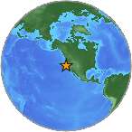
39.04°N 123.34°W
Depth: 0km


| Location | MMI | Resp. | Distance | Latitude | Longitude |
|---|---|---|---|---|---|
| MENLO PARK | 2 | 1 | 201 | 37.48°N | 122.18°W |
| PETALUMA | 2 | 1 | 113 | 38.23°N | 122.56°W |
| BOONVILLE | 2 | 2 | 4 | 39.01°N | 123.39°W |
| UKIAH | 1 | 1 | 14 | 39.14°N | 123.22°W |
- City mapJPG | PDF | PSMap of responses by city or ZIP code
- Intensity vs. DistanceJPG | PSPlot of Attenuation (fall-off) with distance for each intensity versus its distance from the epicenter
- Responses vs. TimeJPG | PSPlot of total number of responses since the event
- Product ListXMLList of available DYFI maps and data for this event
- Intensity SummaryTXT | XMLTable of intensities aggregated by city or ZIP code
