|
|
|
|
|
|
|
|
|
|
|
|
|
Average of
lowest 5 consecutive years during drought years 2000-2006 in Kansas
|
|
|
|
|
|
|
|
Previous Documented Droughts
|
|
|
|
|
|
|
Station Name
|
Average 2000-2006
|
Average
|
Average
|
Average
|
Average
|
Average
|
Long-term
|
Years of
|
Remarks
|
|
|
|
Streamflow (cfs)
|
1929-41
|
1952-57
|
1962-72
|
1974-82
|
1988-92
|
annual
|
record
|
|
|
|
|
|
streamflow (cfs)
|
streamflow (cfs)
|
streamflow (cfs)
|
streamflow (cfs)
|
streamflow (cfs)
|
average
|
|
|
|
|
Beaver Creek near
Cedar Bluffs
|
0.047
|
no data
|
6.45
|
3.48
|
1.65
|
1.79
|
12.2
|
58
|
|
|
|
Prairie Dog Creek
near Woodruff
|
2.37
|
no data
|
31.4
|
8.7
|
3.65
|
3.74
|
24.9
|
63
|
|
|
|
Republican River
near Hardy
|
53.7
|
557
|
233
|
264
|
202
|
138
|
470
|
73
|
1933-41 only
|
|
|
Republican River
at Concordia
|
153
|
no data
|
291
|
470
|
390
|
254
|
615
|
60
|
|
|
|
Republican River
at Clay Center
|
208
|
708
|
331
|
685
|
575
|
395
|
935
|
88
|
|
|
|
Big Creek near
Hays
|
6.59
|
no data
|
10.8
|
15.2
|
11.6
|
6.50
|
31.2
|
59
|
|
|
|
Smoky Hill River
at Ellsworth
|
56.7
|
193
|
107
|
197
|
117
|
96.4
|
232
|
95
|
|
|
|
Smoky Hill River
near Mentor
|
91.5
|
no data
|
189
|
257
|
246
|
120
|
375
|
65
|
|
|
|
Smoky Hill River
at Enterprise
|
413
|
664
|
761
|
824
|
1010
|
559
|
1543
|
71
|
1935-41 only
|
|
|
North Fork Solomon River at Portis
|
21.5
|
no data
|
85.3
|
71.1
|
43.3
|
43.0
|
115
|
60
|
|
|
|
South Fork Solomon River at Osborne
|
11.6
|
no data
|
57.7
|
22.4
|
26.6
|
26.0
|
106
|
85
|
|
|
|
Solomon River at Niles
|
121
|
239
|
290
|
210
|
314
|
252
|
552
|
94
|
|
|
|
Saline River near Russell
|
20.2
|
no data
|
59.5*
|
66.5
|
46.7
|
18.9
|
91.7
|
55
|
1952,53 only
|
|
|
Saline River near Tescott
|
41.7
|
124
|
182
|
72.2
|
89.1
|
76.3
|
215
|
86
|
|
|
|
Kansas River at
Wamego
|
2420
|
3201
|
2948
|
4176
|
5310
|
2633
|
5058
|
86
|
|
|
|
Soldier Creek at Topeka
|
103
|
44.6*
|
20.1
|
101
|
144
|
99.4
|
155
|
70
|
|
|
|
Kansas River at
Lecompton
|
2198
|
no data
|
2540*
|
4303
|
5932
|
3490
|
7116
|
69
|
|
|
|
Marais des Cygnes River at Ottawa
|
580
|
372
|
199
|
606
|
717
|
384
|
693
|
90
|
|
|
|
Arkansas River at
Syracuse
|
75.2
|
181
|
146
|
169
|
32.5
|
164
|
288
|
89
|
|
|
|
Arkansas River at
Garden City
|
4.24
|
51.7
|
56.7
|
234
|
no data
|
30.5
|
177
|
66
|
missing 1970-86
|
|
|
Arkansas River at
Dodge City
|
0.26
|
no data
|
80.5
|
99.3
|
1.15
|
7.91
|
130
|
65
|
|
|
|
Arkansas River
near Kinsley
|
0.11
|
no data
|
97.5
|
117
|
22.8
|
12.6
|
122
|
61
|
|
|
|
Arkansas River at
Great Bend
|
12.4
|
no data
|
188
|
270
|
82.3
|
31.9
|
250
|
67
|
|
|
|
Pawnee River near Rozel
|
8.16
|
35.6
|
41.1
|
32.0
|
21.3
|
17.3
|
58.9
|
81
|
|
|
|
Little Arkansas
River at Valley Center
|
292
|
68.4
|
74.2
|
223
|
325
|
143
|
314
|
83
|
|
|
|
Arkansas River at
Wichita
|
653
|
365*
|
434
|
763
|
843
|
445
|
1040
|
71
|
missing 1929-34
|
|
|
Ninnescah River near Peck
|
498
|
no data
|
259
|
263
|
489
|
327
|
522
|
68
|
1939-41 only
|
|
|
Arkansas River at
Arkansas City
|
1813
|
707
|
859
|
1409
|
1637
|
1100
|
1925
|
87
|
|
|
|
Walnut River at Winfield
|
1252
|
260
|
179
|
654
|
553
|
552
|
893
|
84
|
|
|
|
Medicine Lodge River near Kiowa
|
140
|
70.2*
|
no data
|
96.1
|
130
|
125
|
151
|
61
|
1939-41 only
|
|
|
Crooked Creek
near Englewood
|
8.51
|
no data
|
37.5
|
15.5
|
15.8
|
10.8
|
28.4
|
63
|
|
|
|
Verdigris River near Altoona
|
673
|
no data
|
152
|
327
|
474
|
648
|
761
|
67
|
1940-41 only
|
|
|
Verdigris River at Independence
|
1813
|
677
|
388
|
740
|
1221
|
1580
|
1782
|
91
|
|
|
|
Fall River near
Fredonia
|
565
|
no data
|
94.0
|
228
|
328
|
380
|
512
|
67
|
1939-41 only
|
|
|
Caney River near Elgin
|
310
|
no data
|
72.5
|
94.7
|
159
|
228
|
274
|
66
|
|
|
|
Neosho River at Council Grove
|
96.0
|
no data
|
24.7
|
54.0
|
80.3
|
35.5
|
124
|
67
|
1939-41 only
|
|
|
Cedar Creek near
Cedar Point
|
56.2
|
no data
|
10.4
|
43.1
|
39.3
|
41.3
|
57.5
|
67
|
1939-41 only
|
|
|
Neosho River near Iola
|
1640
|
589
|
381
|
1103
|
1400
|
1290
|
1849
|
95
|
|
|
|
Neosho River near Parsons
|
2219
|
849
|
640
|
1359
|
1967
|
2120
|
2720
|
84
|
|
|
|
|
|
|
|
Note: Highlighted
mean annual streamflows indicate lowest value
|
|
|
|
* indicates
incomplete data for period
|
|
|
|
|
|
|
|
|
|
|
|
|
|
|
|
 DROUGHT WATCH
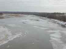 Kansas River at DeSoto, January 21, 2003, discharge 317 cubic feet per second. Photograph by J. Barnard, USGS

