 DROUGHT WATCH
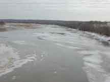 Kansas River at DeSoto, January 21, 2003, discharge 317 cubic feet per second. Photograph by J. Barnard, USGS
DATA CENTER WATER DATA & STUDIES INFORMATION CENTER ABOUT KANSAS WSC USGS IN YOUR STATE
USGS Water Science Centers are located in each state.
|
Drought Definitions
Drought is a period of abnormally dry weather that persists long enough to produce a serious
hydrologic imbalance (for example, crop damage, water supply shortage, etc.) The severity of
the drought depends upon the degree of moisture deficiency, the duration, and the size of the
affected area. (From National Oceanic and Atmospheric Administration).
- Acre-foot.
- Volume of water required to cover 1 acre of land (43,560 square feet) to a depth
of 1 foot; equivalent to 325,851 gallons.
- Cubic feet per second (ft³/s).
- A unit of measurement expressing rates of discharge. One cubic foot per
second is equal to the discharge of a stream of rectangular cross section,
1 foot wide and 1 foot deep, flowing water an average velocity of 1 foot per
second. Equivalent to 448.8 gallons per minute.
- Discharge.
- Rate of flow; a volume of fluid passing a point per unit time, commonly expressed
as cubic feet per second, million gallons per day, or gallons per minute.
- Drainage area.
- Drainage areas are measured using the most accurate maps available. Because the
type of maps available varies from one basin to another, the accuracy of drainage
areas likewise varies. Drainage areas are updated as better maps become available.
- Drainage basin.
- A part of the surface of the Earth that is occupied by a drainage system, which
consists of a surface stream or a body of impounded surface water together
with all tributary surface streams and bodies of impounded surface water.
Land area drained by a stream or river.
- Drought.
- Drought is a condition of moisture deficit sufficient to have an adverse effect on
vegetation, animals, and man over a sizeable area.
Other sources for definitions of drought are:
- Gage datum.
- An arbitrary datum plane that is established for a particular gaging station to
which water-surface elevations can be compared.
- Gage height.
- See Stage.
- Gaging station.
- A site on a stream, canal, lake, or reservoir where systematic observations of gage
height or water discharge are obtained by a gage, recorder, or similar
equipment.
- Keetch-Byram Drought Index.
- A soil drought index that ranges from 0 (no drought) to 800 (extreme drought) and
is based on soil capacity of 8 inches of water. Factors in the index are maximum
daily temperature, daily precipitation, antecedent precipitation, and annual
precipitation.
- 0 - 200, Typical of spring dormant season following winter precipitation.
- 200 - 400, Typical of late spring, early growing season.
- 400 - 600, Typical of late summer, early fall.
- 600 - 800, Often associated with more severe drought with increased fire
danger.
- Minimum desirable streamflow.
- The Kansas Water Office defines minimum desirable streamflow (MDS) as flow
that maintains the base flow for uses within the stream that are nonconsumptive.
They do not have priority over vested and senior appropriation rights filed prior
to April 12, 1984, nor are they maintained throughout all drought conditions. The
KWO identifies candidate streams and establishes and monitors MDS's on them. The
Division of Water Resources, Kansas Department of Agriculture administers the flow.
- Lowest daily mean.
- The minimum daily mean discharge for the year or for the designated period.
- Palmer Drought Index.
- An index that indicates long-term moisture deficiencies or surpluses. It uses 0 as
normal, drought is shown as a negative number (-2, moderate drought; -3, severe
drought; and -4, extreme drought). Likewise, excessive moisture is shown as a
positive number.
- Period of record.
- This indicates the period for which records have been published for the station or
for an equivalent station. An equivalent station is one that was in operation at a
time that the present station was not and whose location was such that flow at it
can reasonably be considered equivalent to flow at the present station.
- Precipitation.
- Rain, snow, hail, or sleet.
- Real-time data.
- Data collected by automated instrumentation and telemetered and analyzed quickly
enough to influence a decision that affects the monitoring system.
- Recurrence interval.
- The average interval of time within which the magnitude of a given event, such as a
drought, will be equaled or exceeded one time.
- Stage.
- The height of a water surface above an established datum. Used interchangeably
with gage height.
- Streambank.
- The margins of a stream channel. Banks are called right and left as viewed facing
the direction of flow.
- Streamflow.
- The discharge that occurs in a natural channel. Although the term discharge can be
applied to the flow of a canal, the word "streamflow" uniquely describes the
discharge in a surface stream course.
- Surface runoff.
- That part of the runoff that travels over the soil surface to the nearest stream
channel. It also is defined as that part of the runoff of a drainage basin that has
not passed beneath the surface following precipitation.
- Surface water.
- Water on the surface of the Earth.
- Water year.
- The water year deals with the surface-water supply for a 12-month period, October 1
through September 30. The water year is designated by the calendar year in which
it ends and which includes 9 of the 12 months. Thus, the year ending September 30,
1999, is called the "1999 water year."
Note: Some definitions were excerpted from other sources.
|

