
 Feeds & Data
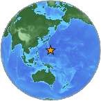
Magnitude 5.0 - MARIANA ISLANDS REGION
2009 January 13 18:45:44 UTC
Earthquake Details
| Magnitude | 5.0 |
|---|---|
| Date-Time |
|
| Location | 20.044°N, 147.024°E |
| Depth | 27.4 km (17.0 miles) (poorly constrained) |
| Region | MARIANA ISLANDS REGION |
| Distances | 200 km (125 miles) NE of Agrihan, Northern Mariana Islands 230 km (140 miles) ESE of Farallon de Pajaros, N. Mariana Islands 555 km (345 miles) NNE of SAIPAN, Northern Mariana Islands 765 km (475 miles) NNE of HAGATNA, Guam |
| Location Uncertainty | horizontal +/- 6.7 km (4.2 miles); depth +/- 31.9 km (19.8 miles) |
| Parameters | NST= 89, Nph= 89, Dmin=750.5 km, Rmss=0.79 sec, Gp= 76°, M-type=body magnitude (Mb), Version=R |
| Source |
|
| Event ID | us2009bubm |
- This event has been reviewed by a seismologist.
- Did you feel it? Report shaking and damage at your location. You can also view a map displaying accumulated data from your report and others.
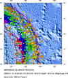
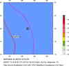
Earthquake Maps


Scientific & Technical Information
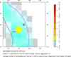
 Historic Moment Tensor Solutions
- Preliminary Earthquake Report
- U.S. Geological Survey, National Earthquake Information Center:
World Data Center for Seismology, Denver
