

Many online systems will be unavailable today (Jan 15) from 3:30 pm - 7:30 pm for hardware maintenance
Many online systems will be unavailable today (Jan 15) from 3:30 pm - 7:30 pm for hardware maintenance
National Oceanic and Atmospheric AdministrationClimate of 2000 - JulyWestern U.S. Wildfires National Climatic Data Center, 15 August 2000 |
 larger image |
|
| Heat signatures (red) and dense smoke (light blue) blanket large areas of Idaho and Montana. |

Contents of This Report: |
Overview |
| Above-normal temperatures and lack of precipitation throughout most of the inter-mountain West contributed to conditions that have created the worst wildfire season in the past 50 years. For the past seven months (year-to-date) average temperatures in many western states have been at or near record levels. For the January through July period, New Mexico, Utah and Texas set records for the warmest such period during the past 106 years. Five other western states (Arizona, Colorado, Nevada, Wyoming, and Idaho) experienced their 2nd or 3rd warmest year-to-date periods on record. The persistence of much-above-average temperatures with below-normal precipitation has contributed to the current wildfire problem. |
Long-Term Drought Index |
| As of August 11, more than 60 large wildfires burned in ten western states. The National Interagency Fire Center has the most recent maps available. Dry thunderstorms continue to produce lightning strikes that ignite the already dry timber and grasslands brought about by months of hot and dry conditions. The Palmer Drought Index map shows long-term (cumulative) drought and wet spell conditions. By the end of July 2000, long-term drought continued across a large part of the inter-mountain West. | 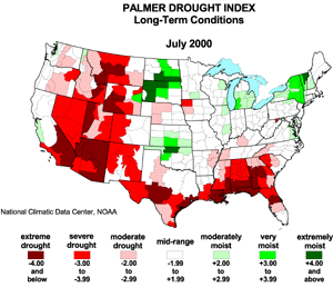 larger animated image |
| On these maps, the red shading denotes drought conditions while the green shading indicates wet conditions. Severe to extreme drought covered Arizona and Nevada as well as much of New Mexico, Utah, Wyoming and Montana. Moderate to severe drought conditions extended into Idaho and eastern areas of Washington and Oregon. Water deficits caused by extended periods of below normal precipitation created conditions that contributed to the current wildfire problem. |
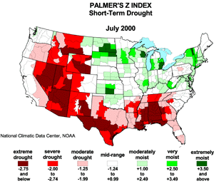
Short-Term Drought Index |
| The severity of this year's wildfire season is made worse by a lack of rainfall in recent weeks which has contributed to worsening moisture conditions on a short-term basis. The Palmer Z index better reflects short-term moisture shortages and as such is a better indicator of fire potential. The animated map below (of the past 12 months) shows the development of severe and extreme drought throughout the past 3 months in the western states. |
 larger animated image |
The animated maps show the geographical pattern of the moisture anomalies for the last 12 months. On these maps, the red shading denotes dry conditions while the green shading indicates wet conditions. |

|
The Palmer Z Index is used as a measure of short-term moisture shortages. Research by Tom Karl (Journal of Applied Climatology, 1986) suggests that it may be a useful indicator of fire potential. An overlay of wildfire location (as of August 11, 2000) on top of the Palmer Z index map for July 2000 clearly shows the strong correspondence between drought and the incidence of wildfires. Most wildfires have occurred in areas experiencing moderate to extreme drought. |
| The adjacent time series shows monthly Palmer Z index values during the past 100 years for southwestern Montana, an area currently experiencing several wildfires. Although the index has been lower in the past, conditions have deteriorated rapidly in recent months bringing the short term index to near record levels. |  larger image |
 larger image |
A time series of the past ten years more clearly shows current conditions with respect to the recent past. The Z index has not reached these low levels since March 1992, and a similar string of negative index values (11 months in a row) has not occurred in the past ten years. |
| Severe drought conditions are also present in the central mountains of Idaho, another active wildfire area. But although extremely dry, this plot of Palmer Z index values shows the presence of drier conditions several times in the past 100 years. |  larger image |
Precipitation Deficits |
| The table below shows precipitation deficits (in inches) and the rank for each state for the year-to-date, most recent two months, and the past 12 month period. Precipitation is below normal in every state during the twelve month period and below normal for all but one state in the year-to-date and most recent two month period. (Ranks are calculated by state with respect to each state's 106 year period of record.) |
| State | Jun-July 2000 | Departure (in) | Jan-July 2000 | Departure (in) | Aug 1999-July 2000 | Departure (in) |
|---|---|---|---|---|---|---|
| AZ | 13th driest | -1.06" | 8th driest | -2.69" | 7th driest | 4.29" |
| NM | 36th wettest | +0.21" | 31st driest | -0.98" | 33rd driest | -1.61" |
| CO | 28th driest | -0.60" | 32nd driest | -1.00" | 39th driest | -1.12" |
| UT | 12th driest | -0.73" | 46th driest | -0.32" | 22nd driest | -2.24" |
| NV | 4th driest | -0.83" | 48th wettest | +0.04" | 18th driest | -1.92" |
| WY | 27th driest | -0.75" | 32nd driest | -0.71" | 21st driest | -1.76" |
| MT | 28th driest | -0.87" | 20th driest | -1.81" | 19th driest | -2.22" |
| ID | 11th driest | -1.15" | 34th driest | -0.86" | 23rd driest | -2.60" |
| Maps of percent-of-average precipitation (below) show the persistence of below normal precipitation amounts throughout much of the western U.S. Average precipitation during the past 18 months has been within 70-90% of normal. But when averaged within the most recent 3 month period, precipitation amounts have been between 30 - 70% of normal throughout much of the inter-mountain West. The lack of rainfall in the past 3 months in combination with below normal precipitation for much of the past 18 months has worsened already drier than normal conditions. (These maps were provided by the Western Regional Climate Center (WRCC) using data from the Climate Prediction Center and the National Climatic Data Center.) |
| 18-Month % of Average | 12-Month % of Average | 6-Month % of Average | 3-Month % of Average |
| Maps of the Standardized Precipitation Index (SPI) (also provided by the WRCC) for the same periods also show dry conditions across many of the same areas. The SPI provides a single numeric value to precipitation which facilitates comparisons across regions with different climates. Dry conditions are especially widespread across the inter-mountain West in the latest 3-month period. |
| 18-Month SPI | 12-Month SPI | 6-Month SPI | 3-Month SPI |
Regional Precipitation Time Series |
| Wildfires have been numerous in the Southwest Region (Arizona, New Mexico, Utah, Colorado) and Northern Rockies. Precipitation totals in these regions have been below normal for many months. Over the past four months, precipitation in the Southwest region has averaged only 3.27 inches. This is two inches below normal and the sixth driest such four month period on record. |  larger image |
 larger image |
In the Northern Rockies (Western Montana and Adjacent Idaho), where more than 20 wildfires were burning on August 11, precipitation during the most recent two month period (June-July) has been less than 60% of normal. |
 larger image |
Lack of precipitation and above normal temperatures in Arizona have led to extreme drought in all but one division. The adjacent precipitation time series for the most recent 12 month period shows the magnitude of the precipitation deficit across the state. Average precipitation is 4.29 inches below normal, making the most recent twelve months the 7th driest such period on record. |
| Precipitation deficits have also been extremely large in Nevada. As shown in the adjacent chart, the most recent two month period has been the fourth driest such period on record. |  larger image |
Climate and Wildfires - Answers to Frequently Asked Questions about the climate related contributing factors to wildfires. Short answers to very complex conditions. |
| How does weather and climate affect the incidence of wildfires?
The climate related variables that affect the severity of the wildfire season are those that affect soil moisture content, vegetation density, and the moisture content of live vegetation. Extended periods of above-normal temperatures and below-normal rainfall are key factors that contribute to an active wildfire season. Available moisture is rapidly lost due to high evapotranspiration rates under hot and dry conditions. If the losses due to evapotranspiration are not replaced through precipitation, below-normal soil and vegetation moisture levels increase the potential for wildfire development. Are a lack of precipitation and hot temperatures the only factors that affect the severity of the wildfire season?
No. Although extended periods of hot and dry weather contribute to the incidence of wildfires, several other factors play important roles. Vegetation density, wind speeds, humidity, and the incidence of lightning producing thunderstorms are critical factors that help determine the extent to which wildfires develop. Has it ever been hotter than it is in the western U.S. today?
Yes. Some states, such as New Mexico, Utah and Texas, set records for the warmest January through July period. Other states, such as Arizona, Nevada, Colorado, Wyoming, and Idaho endured near-record average temperatures during the same period. But although long-term average temperatures are at or near record levels in some western states, average monthly temperatures for the month of July were much less extreme. Has it ever been drier than it is in the western U.S. today?
Yes. Although severe and extreme drought conditions are widespread throughout the western US, many areas have experienced drier periods than those experienced in the recent past. On a statewide basis, the January through July period was drier than normal throughout most western states, but not near record levels. The Palmer short-term drought index has also been lower several times in the past 100 years. |
| For additional information on the 2000 wildfire season please see the National Interagency Fire Center web site or the U.S. Forest Service Fire and Aviation web site. |
 For all climate questions other than questions concerning this report, please contact the National Climatic Data Center's Climate Services Division: For all climate questions other than questions concerning this report, please contact the National Climatic Data Center's Climate Services Division:
Climate Services DivisionFor further information on the historical climate perspective presented in this report, contact:
NOAA/National Climatic Data Center
|


