
 Feeds & Data
ShakeMaps
ShakeMap is a product of the U.S. Geological Survey Earthquake Hazards Program in conjunction with regional seismic network operators. ShakeMap sites provide near-real-time maps of ground motion and shaking intensity following significant earthquakes. These maps are used by federal, state, and local organizations, both public and private, for post-earthquake response and recovery, public and scientific information, as well as for preparedness exercises and disaster planning.
Networks producing ShakeMaps
Click a network name to view a list of events, or on an image to view the event
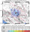
S California
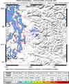
10370561N California

40230187Pacific NW
0811260731Nevada

2009007_271011Utah

1000001268Hawaii

00031867Alaska

86206Global

2009bwa8
Last 10 ShakeMaps from any Network
A list of all ShakeMaps is available in the ShakeMap Archive
| Mag | Name/Epicenter | Date | Time | Lat | Lon | Network | Event ID |
|---|---|---|---|---|---|---|---|
| 7.4 | EAST OF THE KURIL ISLANDS | Jan 15 2009 | 17:49:39 UTC | 46.859 | 155.173 | Global | 2009bwa8 |
| 5.7 | SOLOMON ISLANDS | Jan 15 2009 | 16:15:00 UTC | -10.338 | 161.225 | Global | 2009bwaz |
| 3.9 | 11 km S of Tres Pinos, CA | Jan 15 2009 | 14:43:53 UTC | 36.690 | -121.310 | N California | 40230187 |
| 6.8 | SOUTHEAST OF THE LOYALTY ISLANDS | Jan 15 2009 | 07:27:21 UTC | -22.379 | 170.624 | Global | 2009bwaf |
| 6.0 | MID-INDIAN RIDGE | Jan 13 2009 | 01:04:42 UTC | -13.194 | 66.060 | Global | 2009buad |
| 3.6 | 4.5 mi N of town of Big Bear Lake, CA | Jan 11 2009 | 01:05:59 UTC | 34.309 | -116.915 | S California | 10370561 |
| 3.8 | 17.4 km (10.8 mi) SW of Ukiah, CA | Jan 10 2009 | 09:18:11 UTC | 39.032 | -123.343 | N California | 51214975 |
| 4.6 | 47.9 miles SE of Adak | Jan 09 2009 | 11:34:55 UTC | 51.373 | -175.884 | Alaska | 86206 |
| 4.5 | 0.5 mi W of San Bernardino, CA | Jan 09 2009 | 03:49:46 UTC | 34.107 | -117.304 | S California | 10370141 |
| 5.7 | CARLSBERG RIDGE | Jan 09 2009 | 03:44:38 UTC | 10.437 | 56.992 | Global | 2009bqal |
