Biological
Responses to the
1980 Eruptions of Mount St. Helens |
Mount
St. Helens
National Volcanic Monument |
Life
Returns: Frequently Asked Questions about
Plant and Animal Recovery Following the 1980 Eruption
The following written
information and photo captions are available for use as direct quotes for media
stories, guidebooks, textbooks, etc. Please use this material in the educational
context for which it is intended. Quotes can be attributed to Peter Frenzen,
Monument Scientist. For use of photographs please see Use
Conditions listed on the Photo Gallery page.
Thank you,
Peter Frenzen
Monument Scientist
USDA Forest Service
Mount St. Helens National Volcanic Monument
Vegetation
How were the forests at Mount St. Helens influenced by the May 18, 1980 eruption?
What is status of plant recovery
at the volcano 25 years after the eruption?
How is plant recovery
likely to proceed in the future?
What was the most
surprising discovery immediately following the eruption?
Were there any plants that survived the
eruption?
What is the long-term outlook
for vegetation recovery in the Monument?
Wildlife
What
major wildlife species have returned?
What is the long-term outlook
for wildlife?
How were birds affected by the eruption?
How were small mammals affected
by the eruption?
How were insects affected by the eruption?
Who were the first colonists in the
blast zone and what is their significance?
Streams,
Lakes, Amphibians, Fish
How
were streams affected by the eruption?
How were amphibians (frogs,
toads, etc.) and reptiles (snakes and lizards) affected?
How were lakes affected by the eruption?
Are there fish in Spirit Lake?
How did the fish get to
Spirit Lake?
What is the future of fishing
and other recreation at Spirit Lake?
Microbial
Activity
What have scientists learned from their studies of microbial activity in steam
fumaroles and thermal springs around the volcano?
Recovery
What efforts were successful in aiding the recovery process?
Were any trees replanted after
the eruption?
Were there any recovery
efforts that were not a complete success?
Erosion
Why was erosion important to the recovery of vegetation on the Monument?
Science
What is the role of science in the National Volcanic Monument?
What is the position of
Monument Scientist?
What is the status of research in Mount
St. Helens?
The
1980 eruptions of Mount St. Helens blew down or scorched 230 square miles (500
square km) of forest. The catastrophic failure of the volcano's summit and topographic
channeling of the lateral blast produced a complex gradient of disturbance that
ranged from complete scouring and burial by high temperature material in the
Spirit Lake basin to a dusting of volcanic ash that fell on forests northeast
of the blast zone.
 |
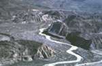
The
distribution of forest vegetation around Mount St. Helens prior to the
1980 eruption is visible in this false color composite image from the
Landsat MSS satellite. The western boundary of the Gifford Pinchot
National Forest is easily defined by the large clearcuts on private
lands northwest of the volcano. |
 |
The
massive size of the 230 square mile blast zone as seen from space is
revealed in this 1980 false color composite image from the Landsat MSS
satellite. (Landsat,
MSS Composite, 1980)
|
For
purposes of description the gradient is simplified into five distinct disturbance
zones. The following is a brief description of each zone starting with the most
heavily disturbed surfaces closest to the volcano and then working outward toward
the margins of the blast zone where disturbance was less and more organisms
survived.
 |
Map
of the five distinct disturbance zones formed by the May
18, 1980 eruption.
(USDA
Forest Service, T. Valentine)
|
| |
|
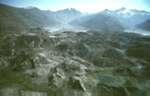
Pyroclastic
Flows -- On the afternoon of May 18,1980, long after the lateral
blast and debris avalanche had run their course, fiery flows of super-heated
pumice and gas flowed from the crater and into the valley immediately north
of the crater. Due to extreme temperatures (1300 degrees F, 700 o C)
no organisms or organic material survived on the pyroclastic flow deposits.

Before
the 1980 eruption the Spirit Lake basin was cloaked in old-growth forest.
The signboard marks a vegetation plot, one of only a few places where the
Forest Service had recorded the composition of pre-eruption vegetation at
an individual species level.
(USDA Forest Service, 1979)

All traces
of the pre-eruption forest were erased, first scoured and buried by the debris
avalanche and then sterilized by fiery pyroclastic flows that surged from
the crater later that afternoon. The signboard marks same the same
location as pre-eruption photo. The post-eruption plot had to be re-located
using surveying instruments. (USDA Forest Service, 1980).
Debris
Avalanche -- A heterogeneous deposit composed of large mounds and depressions
produced when the north side of the mountain collapsed and slid away in the
largest landslide in recorded history (0.6 cubic miles, 2.5 cubic km of material).
In less than 10 minutes, the debris avalanche of rock and sediments filled
a 20 square mile area (60 km 2 ) of the North Fork Toutle River valley to an
average depth of 150 feet (45 m). Plant survival on these deposits was
limited to a few individual plants that sprouted from root fragments that, by
chance, ended up on the surface of the deposit.

Massive
chunks of the volcano, called hummocks, were transported down the North Fork
Toutle River valley at estimated speed greater than 60 mph (27 m/sec).
The hummocks are the small, steep hills that appear in the photograph.
The massive debris avalanche deposit created a natural dam holding back the
waters of Coldwater Lake until an outlet channel was constructed. (USGS,
1984)
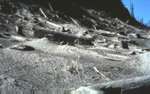
Lahars
(mudflows) -- Cement-like slurries of glacial melt-water, boulders,
and sand-sized sediments fed by melting ice and snow swept down streams around
the volcano. The largest lahars (mudflows) occurred as water trapped
within the debris avalanche deposit coalesced and flowed down the valley of
the North Fork Toutle River. The massive Toutle River lahar flowed at
velocities up to 27 mph (12 m/sec) and deposited more than 45 million cubic
yards (35 million cubic meters) of sediment in the Columbia River channel blocking
ocean-going shipping for 13 days until emergency dredging was completed.
Within
two minutes of the start of the eruption, hot fragmented rock and gases boiled
over the south crater rim melting almost 30 feet (9 m) of snow and ice from
the Shoestring Glacier. The resulting flood of melt water produced lahars
that flowed into the Muddy River and Pine Creek to the south and east of the
volcano. Survival was limited to a few individual plants that sprouted
from roots swept along the surface of the deposit. The overall rate of
plant recovery on mudflows has been comparatively rapid due to their inherently
narrow width and the tremendous influx of seed from adjacent, undisturbed forest
that surrounds the mudflow deposits.
 |
 |
South
side of Mount St. Helens and Shoestring Glacier prior to the 1980
eruption.
(USGS,
D. Miller) |
Muddy
River lahar deposit following the eruption.
(USDA Forest
Service,
F.
Valenzuela, 1981) |

Lahars
scoured and buried more than 100 miles (160 km) of river channel on the west
and southeast sides of the volcano. The maximum height of the flow
is evidenced by mud marks on trees 26 feet (8 m) above the Muddy River.
The two people and helicopter visible in the photo provide a sense of scale.
(J.
Franklin, USDA Forest Service, 1980)
Lateral
Blast (Downed Tree) Area -- Within
a 15 mile (25 km) radius north of the volcano the sideways-directed blast completely
fragmented, blew down, or scorched and killed the forest. The speed of
the cloud of fragmented rock and hot gases ranged from 220 to 670 miles per
hour (360-1080 km/hour). Plant survival within the blast area varied
from little to none on nearby hillsides to areas with considerable survival
in sheltered locations and on the outer margins of the blast zone.
The
lateral blast area is divided into three distinct zones based upon their relative
proximity to the blast and the degree of impact:
Tree
Removal Zone -- The
impact of the blast was greatest on hillsides directly facing the volcano
within a 5-mile (8 km) radius north of the volcano. Entire old-growth
trees were pulled apart by the 650-mile per hour blast (300 m/sec) and their
splintered remains, in turn, became part of the blast.

Before
the eruption the ridges north of the volcano were shrouded in old-growth Pacific
silver fir and mountain hemlock forests. The forest in this photo is
growing on the site of the now popular Windy Ridge viewpoint, four miles (6
km) northeast of the volcano. The signboard marks a vegetation plot,
one of only a few places where the composition of pre-eruption vegetation
was recorded at an individual species level. (M. Hemstrom, USDA Forest Service,
1979)

A
repeat photo of the same location shows the scouring effects of the 300 mph,
stone-filled blast that not only toppled the trees but also ripped them from
the ground (blast direction is from left to right). The blast stripped
the branches from the trees and deposited a jumbled pile of logs on the far
side of the ridge. (USDA Forest Service, 1980)
Downed
Tree Zone -- The lateral blast felled trees up to 12 miles (18 km)
in a 180-degree arc north of the volcano. The rock and ash-filled blast was
channeled by steep mountain topography. Steep mountain ridges and rock outcroppings
deflected the force of the sideways-directed blast leaving sheltered pockets
on north-facing slopes. Late-lying snow banks sheltered patches of small shrubs
and trees from blast heat and scouring.
|
The
blast flowed around and was deflected by steep ridges. Blast direction
in this photo was from left to right. Note the standing dead trees
that were sheltered behind the steep ridge.
(P.
Frenzen, 1980)
|
Standing
Dead Tree Zone -- A narrow zone of standing dead trees that was scorched
and killed by hot blast gases marks the outer margin of the 1980 blast area.
The comparatively narrow width of this zone results from the physics of the
blast and its behavior as it slowed. Shortly after the blast had slowed
to a point where it was no longer felling trees, it reached a point where it
could no longer carry the load of fragmented rock and ash that it was carrying.
The blast gases ramped upward like a hot air balloon relieved of its ballast.
This produced a sharp boundary between scorched and adjacent green trees.

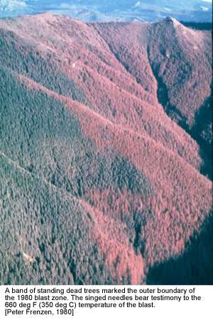
A
band of standing dead trees marked the outer boundary of the 1980
blast zone. The singed needles bear testimony to the 660 deg F (350
deg C) temperature of hot blast gases.
(P.
Frenzen, 1980]
 |
The
singed needles bear witness to the 660 deg F (350 deg C) temperature
of hot blast gases.
(P.
Frenzen, 1980) |
Ashfall
Area -- The 15-mile high ash cloud drifted to the northeast depositing
more than three feet (100 cm) of ash near the volcano and traces of ash hundreds
of miles (km) to the northeast. The ash cloud eventually encircled the
globe.
 |
The
vertical eruption plume continued for more than nine hours on May
18, 1980.
(USGS,
A. Post, 1980) |
The
ashfall coated trees growing northeast of the mountain retarding their growth
for the first year following the eruption. After rain cleared the ash
from the trees, their growth recovered and, in many cases, actually increased
because the ash acted like mulch, retarding the growth of competing understory
vegetation.
 |
Ash-covered
noble fir trees in a young plantation on the Gifford Pichot National
Forest northeast of the volcano.
(USDA
Forest Service, J. Hughes, 1980) |
However, what was good for some trees was very detrimental to others. The ash
caused changes in foliar geometry that resulted in elevated needle temperatures
and the death of foliage especially among old-growth Pacific Silver fir trees
northeast of the volcano.
 |
Ash-covered
noble-fir foliage and needle damage northeast of the volcano.
(USDA
Forest Service, J. Hughes, 1980) |

Prior
to the eruption mountain ridges northeast of the volcano supported old-growth
Pacific silver fir and mountain hemlock forests. The person is standing
at the center of a vegetation plot, one of only a few places where the
composition of pre-eruption vegetation had been recorded at an individual
species level.
(USDA
Forest Service, 1979)

A
repeat photo of the same point, taken after the eruption, shows the effects
of a blanket of volcanic ash that fell from a volcanic ash plume that drifted
to the northeast on the prevailing winds. This is an area located downwind
of the volcano and outside of the blast zone. (USDA Forest Service, 1980)
[back]
What
is status of plant recovery at the volcano 25 years after the eruption?
The
first 25 years of vegetation recovery at Mount St. Helens can be viewed as the
opening chapter in a long-term (200 to 500 year) successional sequence that,
in the absence of another large-scale eruption or other disturbance, will eventually
return the 1980 blast zone to an old-growth forest. During the first
five years after the eruption, vegetation recovery was dominated by surviving
plants that were rooted in pre-eruption soil and managed to sprout through the
overlying deposits of volcanic ash and pumice.

|
Pearly
everlasting sprouts from a small erosion gully following the 1980 eruption.
(USDA Forest Service, J. Franklin, 1980) |
On
steep slopes, vegetation re-establishment was helped by erosion that cut gullies
in the overlying blast and airfall deposits exposing roots in the pre-eruption
soil. Surviving plants that were able to expand vegetatively (spread by
above or below ground runners) greatly accelerated the return of vegetation.
Early established plants helped pave the way for colonizing seeds by
providing shade and by adding life-sustaining mulch to the harsh, open blast
zone. Colonizing species, that established from seeds blown in by the
wind, soon joined the plant survivors.
Since
1995, there has been a steady progression in the number and overall variety
of plants in the blast zone. This is the result of a progressive "in-filling"
process as populations of surviving plants have expanded and colonizing plants
have continued to seed-in between the established plants. Over the last 10 years,
the most conspicuous change has been an increase in the abundance of trees and
shrubs. The overall appearance of the landscape surrounding the volcano has
changed as trees such as red alder (Alnus rubra) and shrubs such as Sitka alder
(Alnus sinuata) and willow (Salix spp.) have established throughout the blast
zone. This process is most evident on the debris avalanche and lahar
(mudflow) deposits, particularly in wet areas formed by ground water seeps and
on pond margins. Throughout the blast zone, seedling to sapling-sized conifers
(evergreen trees) are also becoming common. Over the last 25 years, these
developing shrub and tree species have spread laying the groundwork for the
eventual transformation of the gray blast zone into a thriving coniferous forest
once again.
Vegetation
re-establishment has proceeded somewhat differently on each of the five primary
eruption disturbance zones. In general, the speed of vegetation reestablishment
has varied as a function of the magnitude of initial disturbance, suitability
of the deposits for plant establishment and growth, and proximity to seed sources
from the undisturbed forest outside the blast zone. A broad generalization of
the status of the 25-year vegetation recovery is presented for each disturbance
zone below (these zones are the same as those listed on the preceding map):
Pyroclastic
Flow Deposits -- Plant establishment on surfaces sterilized by 1500
degree F pyroclastic flows has been comparatively slower than other areas in
the 1980 eruption area. This is due to the virtual absence of organic
material on the pumice deposits in the valley immediately north of the crater
and the comparatively greater distance of the Pumice Plain to seed sources from
intact vegetation outside of the blast zone.
 |
 |
Fresh
pyroclastic flow deposits directly north of the crater.
(USGS,
1980) |
Twenty-five
years later the Pumice Plain north of the crater is covered in wildflowers.
(USDA Forest
Service,
P. Frenzen,
2004) |
Prairie
lupine (Lupinus lepidus) has been an important early colonizing plant on the
pyroclastic flow deposits because of its ability to fix nitrogen. Over
time, the dense mats of prairie lupines and other plants are adding organic
matter and nitrogen to the pumice deposits and are helping to pave the way for
other plants to follow.

Prairie
lupines (Lupinus lepidus) have been an important early colonizing plant
on the Pumice Plain (pyroclastic flow deposits) north of the crater.
[James
Cook, University of Wisconsin-Stevens Point, 1999]
As
hardy, high-elevation plants like prairie lupine and other plants have established,
there has been more forage available for large herbivores. As elk and other
animals spend more time grazing on the Pumice Plain they deposit the seeds of
grasses and other plants in their droppings. Over the last decade, the
abundance of grasses is increasing as a result of the presence of large grazing
animals.
View
looking across the Pumice Plain towards the volcano. The clumps of grass visible
in this picture has established from seed transported to the site by elk and
deposited in their droppings.
(James
Cook, Univ. of Wisconsin-Stevens Point, 1999)
Debris
Avalanche Deposit – Plant
establishment on the debris avalanche deposit has been strongly influenced by
substrate stability, availability of water, and proximity to vegetation on adjacent
hillsides that escaped scouring and burial by the debris avalanche. Over the
last 25 years, vegetation development on floodplains adjacent to the North Fork
Toutle River has been minimal. Even though many seeds may sprout each year in
the moist sediments along the river, few seedlings survive the erosion and deposition
of sediments by the continually shifting channel system.
The
barren, gray appearance of the floodplain of the North Fork Toutle River reflects
a lack of vegetation development due to periodic disturbance from seasonal flooding.
(P.
Frenzen, USDA Forest Service, 1988)
 |
Groundwater
seeps were among the first places that seedlings established on the
debris avalanche deposit.
(P.
Frenzen, USDA Forest Service 1983) |
High
winds transport the seeds of trees and other plants great distances across the
comparatively smooth, open debris avalanche and lahar (mudflow) deposits in
the North Fork Toutle River valley. Seeds of all of the common conifers (evergreen
tree species) have blown onto the debris avalanche deposit. In some cases
it appears that these seeds have blown in from intact forests up to five miles
away.

Lodgepole
pine (Pinus contorta) is an example of a successful evergreen tree species
that has established on the debris avalanche deposit. Lodgepole
is a tree that is well adapted for rapid establishment and growth on the
nutrient poor volcanic deposits. Its capacity to produce numerous
seeds at a comparatively young age will ensure its abundance in the future
forest.
(P.
Frenzen, USDA Forest Service, 1999)
Red
alder (Alnus rubra) is an example of a fast growing hardwood tree that has flourished
on the debris avalanche deposit. Alder has an association with bacteria on its
roots that enables it to fix nitrogen. The availability of nitrogen, an essential
nutrient, allows red alder to grow at a rate of two to three feet per year (1
m) on the debris avalanche deposit. The growth rate of red alder far exceeds
the 2 to 3 inch per year height growth (5-8 cm) of the common conifers (evergreen
trees) Douglas fir and western hemlock.
| Red
alder is a fast growing deciduous tree that has been an important
early colonizer on the debris avalanche near Coldwater Lake. As
alder has matured and produced seed it has spread rapidly across
the barren deposits and is working its way across the North Fork
Toutle valley.
(P.
Frenzen, USDA Forest Service, 1999) |
 |

The
most well developed red alder stands are found along the margins of
the debris avalanche deposit where they established first due to the
relative proximity of adjacent seed sources. Within the next decade
much of the debris avalanche deposit will be covered in a dense thicket
of red alder.
(P.
Frenzen, USDA Forest Service, 1999)

A
steady increase in the number of red alder and Sitka alder (Alnus sinuata)
seedlings found in the center of the valley provides testimony to the continuing
spread of these fast growing species across the debris avalanche deposit.
(P.
Frenzen, USDA Forest Service, 1999)
| |
|
|
| Debris
avalanche deposit near Coldwater Lake. Note the soft appeaance
of the deposit surface due to fine material on the surface.
(USDA
Forest Service, F. Valenzuela, 1981) |
The
influence of erosion is evident in the same view rephotographed
two years later.
(USDA
Forest Service, F. Valenzuela, 1981) |
Colonization
of the debris avalanche deposit by red alder is evident in the
same view rephotographed 24 years after the 1980 eruption.
(USDA
Forest Service,
P.
Frenzen, 2004) |
Lahar
(mudflow) deposits – With
the exception of floodplains that are subject to frequent disturbance, plant
establishment has been relatively rapid on lahar deposits. The cement-like lahars
scoured and buried streamside vegetation along streams for great distances beyond
the blast zone boundary. Lahars produce comparatively narrow, ribbon-like deposits
because they are channeled by and confined to stream bottoms. Except for floodplains
that are chronically disturbed, the narrow deposits are quick to revegetate
because of the tremendous amount of seed received from the adjacent, undisturbed
forest that lines the edges of lahar deposits that are located outside of the
volcanic blast zone.

The
Muddy River lahar deposit as seen from the Lahar Viewpoint on the south side
of the volcano, one year after the eruption. Note the undisturbed forest
that lines the sides of the 1980 lahar deposit. The Muddy River is located
on the south side of the volcano and was not affected by the north-directed
lateral blast. The yellow car parked on the road provides some sense
of scale for this enormous lahar deposit.
(F.
Valenzuela, USDA Forest Service, 1981)

The
same view 18 years later shows that forest reestablishment on lahar
deposit is well underway. (P.
Frenzen, USDA Forest Service, 1999)

The
establishment of trees near the margins of the Muddy River lahar deposit has
been rapid. This reflects the heavy rain of seeds from the adjacent, undisturbed
forest. (P. Frenzen, USDA Forest Service, 1999)
Lateral
Blast (Downed Tree) Zone – The speed of vegetation reestablishment
was generally related to the degree of intensity of a given location from the
lateral blast. The most intense scouring and thickest blast deposits were
on ridges directly facing the blast within a five-mile radius north of the volcano.
Geologists called this area, where trees were pulled apart by the force of the
blast or ripped from the ground and blown off the hillsides, the tree
removal zone.
The
impacts of the lateral blast in the tree removal zone is revealed by a time
sequence of photos of vegetation recovery at Windy Ridge viewpoint shows the
eruption impacts and the recovery of vegetation over time.
Before
the eruption, the ridges north of the volcano were shrouded in old-growth
Pacific silver fir and mountain hemlock forest. The forest in this photo
is growing on the site of the now popular Windy Ridge viewpoint, four
miles (6 km) northeast of the volcano. The signboard marks a vegetation
plot, one of only a few places where the composition of pre-eruption vegetation
was recorded at an individual species level. (M. Hemstrom, USDA
Forest Service, 1979)
A
repeat photo of the same location shows the scouring effects of the 300-plus
mph, stone-filled blast that not only toppled the trees but also ripped
them from the ground (blast direction is from left to right). The blast
stripped the branches from the trees and deposited a jumbled pile of logs
on the far side of the ridge. (USDA Forest Service, 1980)

This
repeat photograph of the Windy Ridge viewpoint shows the result of
19 years of plant establishment on the blast-scoured hillside. Note
that vegetation in the foreground is still concentrated in gullies
where buried soil and roots were exposed by erosion.
(P.
Frenzen, USDA Forest Service, 1999)
Plant
community development in the blowndown forest has been most rapid on north-facing
slopes that faced away from the blast and areas where sapling-sized trees and
shrubs were protected by late-lying snow banks. The comparatively rapid growth
of snow-protected trees and shrubs can been seen through a sequence of photographs
taken from the same point.

Blowndown
forest on a north-facing slope near Meta Lake. Snow protected Pacific
silver fir and mountain hemlock trees are growing rapidly in the open
blast zone three years after the eruption.
Re-sprouting
shrubs are also visible.
(P.
Frenzen, USDA Forest Service, 1983)

Same
view of blown down forest near Meta Lake, nine years after the eruption. Note
the growth of the surviving trees and that numerous snow-protected shrubs
have also resprouted.
(P.
Frenzen, USDA Forest Service, 1989)

Same
view of blown down forest near Meta Lake, 14 years after the eruption.
Note the comparative large size and continued growth of the snow-protected
trees and shrubs.
(P.
Frenzen, USDA Forest Service, 1994)

Surviving
trees and shrubs sheltered by snow and wetlands plants that resprouted from
pre-eruption soil lined the shoreline of Meta Lake, four years after the eruption.
(F.
Valenzuela, USDA Forest Service, 1984)

This
repeat photo of the Meta Lake shoreline, seven years after the eruption,
shows the slow but steady growth and expansion of surviving plant species.
(P.
Frenzen, USDA Forest Service, 1987)

The
same view, 19 years after the eruption, shows the reestablishment of wetland
plants along the shoreline of Meta Lake.
(P.
Frenzen, USDA Forest Service, 1999)
In
areas of blowndown forest that were snow-free at the time of the eruption, plant
development has also been rapid. "Weedy" plant species, like fireweed
and pearly everlasting, have established from their abundant, wind-dispersed
seed. In the last several years, it is increasingly evident that establishment
of the future forest is well underway. The seedlings of red alder, willow and
Douglas fir trees can now be found growing among the shattered remains of the
previous forest.

Plant
establishment in areas that were not snow covered at the time of the
eruption can be seen in this view of blown forest near Independence
Pass. Willows, alders and Douglas fir trees have established from seeds
blown in from several miles away.
(P.
Frenzen, USDA Forest Service, 1999)

The
importance of erosion to plant survival and recovery can still be seen 19
years after the eruption on this site where the forest had been clearcut prior
to the 1980 eruption. Note that most of the plant life is still distributed
along the erosion gullies that were carved in the otherwise flat and, therefore,
intact ash deposits. (P. Frenzen, USDA Forest Service, 1999)
Standing
Dead Tree (Singe)
Zone –

The
influence of snow on plant survival and patterns of vegetation recovery
can still be seen in the standing dead forest along the 99-road northeast
of the volcano, 20 years after the eruption. Note the patches of green
where late lying snow provided shelter to small trees and shrubs.
(P.
Frenzen, USDA Forest Service, 1999)

The
growth of the next forest rising beneath the remains of the previous forest
can be seen along the 99-road corridor. These snow-protected Pacific silver
fir and mountain hemlock trees are among the largest naturally established
evergreen trees within the core of the 230 square mile blast zone. (P.
Frenzen, USDA Forest Service, 1999)
 |
 |
 |
|
Standing
dead forest three years after the eruption.
(USDA
Forest Service, 1983) |
Fifteen
years after the eruption, light-seeded "weedy" plant species
have established. Note the number of fallen trees.
(USDA
Forest Service, P. Frenzen, 1995) |
Few
trees remain standing 24 years after the eruption. Establishment
of the next forest is well underway.
(USDA
Forest Service, P. Frenzen, 1995) |
[back]
Over
the last decade, the blast zone north of the volcano has gradually been transformed
from gray to green. This apparent "greening" of the landscape
has resulted from the progressive "pixel by pixel" colonization of
the formerly gray, open space between established plants. As more and more trees
and shrubs establish, evidence of the 1980 eruption will disappear beneath a
layer of developing vegetation. Within a few decades, scattered coniferous trees
such as Douglas fir (Pseudotsuga menziesii), Western hemlock (Tsuga
heterophylla), lodgepole pine (Pinus contorta) and Pacific
silver fir (Abies amabilis) will begin to emerge from beneath
the hardwood and shrub thicket. By 2100, these scattered emerging trees will
begin to converge and the area will take on the appearance of a young forest.
By the year 2200, barring another large-scale eruption or other disturbance,
much of the area will once again be covered in an old-growth forest as it was
before the 1980 eruption. This repeats a cycle of volcanic destruction
and renewal that has been underway during the 40,000 year eruptive history of
the volcano.
 |
 |
|
Debris
avalanche deposit viewed from Johnston Ridge following the eruption.
(USGS,
1980) |
The
progressive greening of the landscape is evident in the same view
24 years after the eruption.
(USDA
Forest Service,
P.
Frenzen, 1980) |
[back]
The
single greatest surprise to scientists entering the blast zone shortly after
the eruption was the realization that many organisms survived in, what initially
appeared to be, a lifeless landscape. Scientists entering the blast zone for
the first time found a mostly gray and brown landscape covered with dead trees
and a uniform covering of ash and pumice.

Pre-eruption
view from the former summit of Mount St. Helens looking north with Spirit
Lake and Mount Rainier in the background. Note the dark green color
of the old-growth forests that occupied the valley to the north of the
volcano and the ridges surrounding Spirit Lake. (Peter Frenzen,
1978)

The
same view after the eruption shows the extensive removal of forest vegetation
north of the volcano. The missing trees were buried by the massive landslide
(debris avalanche) or ripped from the ground and/or toppled by the lateral
blast.
( J. Franklin, USDA Forest Service, 1980)
It
wasn’t long before scientists working in the area found surviving populations
of plants and animals. This was particularly evident in areas protected by snow
cover and where erosion had thinned the overlying ash deposits (along streams
and in gullies that formed on hillslopes). Plants were observed sprouting from
the pre-eruption soil surface and signs of activity by gophers and ants indicated
that subterranean animals (living below ground) had survived beneath the volcanic
ash.
The
survival of plants and animals in the midst of the apparent total devastation
was of special interest to the scientific community. Early studies have demonstrated
that, even after a large-scale, catastrophic disturbance, recovery processes
are strongly influenced by carry over of living and dead organic material from
pre-disturbance ecosystems. At Mount St. Helens, ecosystem recovery was influenced
not only by the survival of plants and animals, but also by the tremendous quantities
of organic material that remained in the standing dead and blown down forest.
[back]
The
early spring timing of the eruption meant that there were still late-lying snow
banks on high mountain ridges that sheltered some forest plants from the full
effects of the blast.

Post-eruption
view of a blast-sheltered, north-facing ridge that was snow-covered
and facing away from the blast at the time of the eruption (blast
was moving from right to left). Note the standing dead trees that
were snapped off at the point where they were taller than the ridgetop.
Trees that survived the eruption under snow can also be seen on the
sheltered side of the ridge. (P. Frenzen, USDA Forest
Service, 1985)
The
most conspicuous plant survivors were isolated patches of sapling-sized Pacific
silver fir (Abies amabilis) and mountain hemlock (Tsuga
mertensiana) trees that survived the eruption intact, bent over beneath
deep snow banks. Other woody plants like huckleberry (Vaccinium spp.)
and salmonberry (Rubus spectabilis) bushes managed to survive on snow-covered
north slopes or in isolated pockets on the backside of steep mountain ridges
that deflected the full force of the blast.

Snow-protected
Pacific silver fir and mountain hemlock trees provided the first early glimpses
of green in a mostly gray and brown landscape. Over time as these survivors
grow they will serve as important sources of seed for the establishment of
the future forest inside the blast zone at Mount St. Helens. (Art McKee,
Oregon State University, 1980)
Timing
of the eruption was also important to the survival of non-woody plants at the
volcano. The eruption hit the plants at a time when they were least vulnerable
to scouring by the blast and burial by volcanic deposits. Late May is a time
when plants on mountain ridges were still dormant having dropped their leaves
and died back to buried roots the previous fall.
The most common means of plant survival was from rootstocks that sprouted from
the surface of the pre-eruption soil where ash deposits were thin (less than
six inches, 15 cm) or where the pre-eruption soil surface had been exposed in
the bottom of erosion gullies.

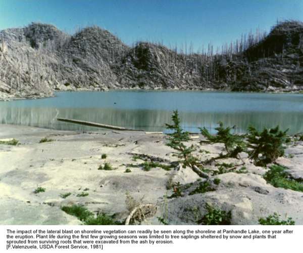
The
impact of the lateral blast on shoreline vegetation can readily be seen
along the shoreline at Panhandle Lake, one year after the eruption.
Plant life during the first few growing seasons was limited to sapling-sized
trees that were
sheltered by snow and plants that sprouted from surviving roots that
were excavated by erosion.
(F.
Valenzuela, USDA Forest Service, 1981)

The
expansion of surviving plant life and recolonization of buried soil exposed
by erosion can be seen in a repeat photograph of the shoreline at Panhandle
Lake, three years after the eruption.
(F.
Valenzuela, USDA Forest Service, 1983)

This
repeat photograph from 1987 shows the continued growth of surviving
trees and shrubs at Panhandle Lake.
(F.
Valenzuela, USDA Forest Service, 1987)
Other
chance circumstances contributed to plant survival throughout the 230 square
mile blast zone. In the blown down forest, scattered plants managed to survive
on blocks of soil that clung to the root masses of upturned trees. Other plants
survived in sheltered pockets underneath the blowndown trees. These lucky survivors
included forest plants species such as bunchberry dogwood (Cornus canadensis),
queen’s cup beadlily (Clintonia uniflora) as well as common shrub
species such as huckleberry (Vaccinium spp.) and elderberry (Sambucus
spp.).

Huckleberries
(Vaccinium spp.) and other forest understory plants resprouted
from soil on the root masses of blown down trees providing an early glimpse
of green in a mostly gray landscape
(J. Franklin, USDA Forest Service, 1982)
The
most common survivors were "weedy plant" species such as fireweed
(Epilobium angustifolium) and pearly everlasting (Anaphalis
margaritacea) that sprouted from the original soil surface in areas that
had been clearcut prior to the eruption.

The
surviving roots of weedy plants, like fireweed, sprouted where they could
reach the ash surface, either through surface cracks or in gullies where
buried soil was exposed by erosion. (J. Franklin, USDA Forest Service,
1980)
At
first glance this ash-covered clearcut, located 9 miles northeast of
the volcano, appeared completely lifeless following the eruption.
(Art McKee, Oregon State Univ., 1980)
 The
same view taken five years later reveals the weedy plant survivors that
sprouted from rootstocks that were present in the pre-eruption soil beneath
the ash. Weedy plant species such as fireweed (Epilobium angustifolium),
pearly everlasting (Anaphalis margaritacea) and Canada thistle
(Cirsium arvense) possess vigorous root systems and are well
adapted to rapid growth in harsh, open conditions.
The
same view taken five years later reveals the weedy plant survivors that
sprouted from rootstocks that were present in the pre-eruption soil beneath
the ash. Weedy plant species such as fireweed (Epilobium angustifolium),
pearly everlasting (Anaphalis margaritacea) and Canada thistle
(Cirsium arvense) possess vigorous root systems and are well
adapted to rapid growth in harsh, open conditions.
(P. Frenzen, USDA Forest Service, 1986)
In
years following the eruption, plants adapted to life in the cool, dark forest
understory succumbed to the comparatively harsh blast zone environment. Seedlings
of "weedy" plants such as fireweed and pearly everlasting that are
better adapted to life in the open, post-eruption environment gradually replaced
the forest plants. Weedy plants are favored in the blast zone because of their
dispersal capabilities and tolerance of environmental extremes.

Plant
life slowly returned to the blown down forest and, because individual plants
were few and far between, the landscape still looked mostly gray three years
after the eruption. Countless seeds drifted into the blast zone but only
a few took root on the sun-baked ash surface. (USDA Forest Service,
1983)

Six
years after the eruption colonizing plants had begun to fill the available
open space and wildflowers framed the blown down forest. Over time these
early colonizing plants have added organic matter and nutrients to the
ash surface helping to modify harsh environmental conditions and pave
the way for other plant life to follow. (P. Frenzen, USDA Forest
Service, 1986)
The
"weedy" plant species that survived in areas that had been clearcut
prior to the eruption and in young plantations north and west of the volcano
provide a tremendous seed source for colonization of the blast zone. Fall visitors
to the Monument encounter millions of cotton-covered seeds drifting on the wind.
At times the drifting seeds of "weedy" plant species are so numerous
that it almost appears to be snowing. As the drifting seeds take hold, the 1980
blast zone is gradually being transformed from gray to green. These early
colonizing plants are the first step towards the reestablishment of the old-growth
forests that once framed Spirit Lake and Mount St. Helens.
[back]
In
the years ahead, we expect that "weedy" plants such as fireweed and
pearly everlasting will continue to dominate the 1980 blast zone. These
early colonizers are being joined by willows and other shrubs. Fast
growing hardwoods such as red alder (Alnus rubra), black cottonwood
(Populus trichocarpa) and bitter cherry (Prunus emarginata)
are spreading across the open blast zone. The future forest is taking
root with the establishment of coniferous trees including Douglas fir (Pseudotsuga
menziesii), Pacific silver fir, noble fir (Abies procera),
western hemlock (Tsuga heterophylla), mountain hemlock and lodgepole
pine (Pinus contorta) . Within the next 50 years, as the young
trees mature, the weed and shrub dominated landscape will begin to take on the
appearance of a young coniferous forest. Within 100 years a mature forest will
cover most of the area. Within 200 years the area will begin to resemble the
old-growth forests that framed the vvolcano prior to the 1980 eruption.
The
slow but steady return of forest vegetation can be seen in this aerial
view of the debris avalanche deposit near Castle Lake five years after
the eruption. Note the green color of wet areas and pond shorelines
where the seeds of sedges, willows and other wetland plants have taken
root.
(P. Frenzen, USDA Forest Service, 1985)

Nineteen
years after the eruption the forest’s return to the debris avalanche is well
underway. One of the most successful trees has been red alder (Alnus
rubra), a tree that disperses easily and is capable of rapid growth
on the nutrient-poor, volcanic deposits. (P. Frenzen, USDA Forest Service,
1999)
It
is difficult to precisely predict the future structure and composition of plant
life at Mount St. Helens due to the uncertainty associated with the prevailing
weather (incidence of recurring drought and/or flooding) or future volcanic
activity. What is certain, however, is that the landscape and biota surrounding
Mount St. Helens will remain in a state of continual change. The cycle of volcanic
activity followed by biotic response at Mount St. Helens has been underway for
more than 40,000 years. It is likely that the cycle will be repeated many times
in the future.

Between
1980 and 1986 there were a number of small steam and ash eruptions as
a series of dome building eruptions built the 1000-foot tall lava dome
in the crater. This is a view of a dome shattering explosive eruption
that occurred in the fall of 1982. (Peter Frenzen, 1982)
[back]
The
most conspicuous wildlife species that have returned to the blast zone are Roosevelt
elk (Cervus elaphus) and the Columbia black-tailed deer (Odocoileus
hemionus). Large mammals did not survive but animals from adjacent, less-disturbed
areas were able to move into the blast zone soon after the eruption. These animals
found prime habitat due to the availability of high quality summer forage from
surviving plants and winter forage from grass and clover planted to control
erosion on the debris avalanche deposit west of the Monument. The availability
of winter forage contributed greatly to the recovery of the elk population.
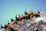
It
is not unusual to see large herds of bull elk running together on the
debris avalanche or in the blast zone north of the volcano. Elk viewing
is a very popular activity among Monument visitors.
(C.
Tonn, USDA Forest Service)
[back]
Given
an area with ample food supply and little human disturbance (public access and
hunting has been restricted in the valley immediately north of the volcano since
the eruption) elk herds have expanded dramatically and have become a visible
part of the Monument. Elk viewing is a popular activity among Monument visitors.
The Washington State Department of Wildlife estimates that elk populations have
returned to near pre-eruption levels (1,750 animals in the area surrounding
Mount St. Helens). In the years ahead it is expected that elk and deer will
continue to be abundant. In the absence of human intervention (e.g. hunting
in the core of the blast zone) it is likely that populations will continue to
increase dramatically until there is a string of hard winters and a dieback
occurs due to a shortage of winter forage.
The
winter of 1998/1999 provided an example of the kind of population fluctuations
that can occur as forest plantations on adjacent private lands mature and the
forage supply decreases in the Mount St. Helens area. The winter of ’98 buried
the available forage for elk and deer beneath a record snow pack (more than
three times normal). More than 200 elk starved to death in the snow-covered
blast zone as winter snow blocked their access to forage in a late spring. The
record snow pack of ‘98 had placed an additional stress on a population that
had already begun to run up against the limits of the available food supply
during the winter season. The reduction in forage was due in part to the growth
of forest plantations on private lands adjacent to the Monument. As the branches
of adjacent plantation trees have grown together the availability of sunlight
for the growth of forage between the plantation trees has been greatly reduced.
What turned out to be a very stressful winter for elk at the volcano turned
into a boon for scavengers and predators. Animals like coyote, bear and even
wolverines were sighted in places in the blast zone where they had never been
seen before.
In
order to examine the relationship between large-herbivores and developing vegetation
the Monument has installed several experimental plots called exclosures where
elk and deer are excluded through the use of an 8-foot tall stock fence. In
each case 1.25 acre (0.5 hectare) area is fenced and the composition and abundance
of developing vegetation is periodically measured both within the fence and
on an adjacent, unfenced "control" plot. The exclosures will provide
a means of assessing how large herbivores are influencing vegetation composition
both in terms of what they eat and terms of the seeds that they deposit in their
droppings.

The
influence of elk on plant establishment and growth can be seen in
the relatively low abundance of fireweed blooms visible in an unfenced
"control" plot that has been repeatedly browsed by elk and
deer. The control plot is located adjacent to the fenced area where
elk and deer have been experimentally excluded since 1991 (for comparison
see fenced plot in next photo). (P. Frenzen, USDA Forest Service,
1994)
 The
increased bloom of fireweed in response to exclusion of elk and deer can be
seen inside this experimental fenced area. This 1.25 acre (0.5 hectare) exclosure
is one of three sets of adjacent fenced and unfenced experimental plots established
by biologists to monitor the influence of large herbivores on plant succession.
The
increased bloom of fireweed in response to exclusion of elk and deer can be
seen inside this experimental fenced area. This 1.25 acre (0.5 hectare) exclosure
is one of three sets of adjacent fenced and unfenced experimental plots established
by biologists to monitor the influence of large herbivores on plant succession.
(P. Frenzen, USDA Forest Service, 1994)

The
biggest difference between vegetation inside versus outside a fenced
elk and deer exclosure on the debris avalanche is the difference in
the growth form of the trees. Trees outside of the fence have a shrubby
appearance due to repeated browsing while trees inside of the fence
exhibit the upright growth form that is typical for trees.
(P. Frenzen, USDA Forest Service,
1994)
[back]
Bird
survival was restricted to areas on the margins of the blast zone where ashfall
was the only disturbance. Recolonization of the blast zone occurred very quickly
(hours, days, weeks) due to the tremendous dispersing capability of birds. Geologists
working in the steaming crater experienced the tremendous dispersal capability
of birds first hand as they were dive bombed by hummingbirds attracted to their
bright orange flight suits (the birds thought they had stumbled upon the largest
flowers they had ever seen!).
Ten
years after the eruptions, few species are present in the pyroclastic flow,
debris avalanche and tree blowdown zones where vegetation recovery has been
relatively slow. The common raven (Corvus corax), mountain bluebird
(Sialia currucoides) and white-crowned sparrow (Zonotrichia
leucophrys) are examples of species that have returned to the most heavily
disturbed areas. The standing dead forests harbor species such as the American
robin (Turdus migratorius), hairy woodpecker (Picoides
villosus) and red-breasted nuthatch (Sitta canadensis)
but lack many of the foliage loving species found in undisturbed forests. Ashfall
areas support bird life similar to adjacent, undisturbed forested sites. In
time as the blast zone returns to a forested condition we should observe a return
of bird life found in adjacent, undisturbed forests.

Birds
like the mountain bluebird (Sialia currucoides) that
nest in cavities in standing dead trees have prospered in the blast
zone
(J. Quiring, USDA Forest Service)
[back]
Of
the 32 species of small mammals thought to be living near Mount St. Helens only
14 were known to have survived. The eruption adversely affected small mammals
either directly through immediate injury or death or indirectly by reducing
the availability of food, water or hiding cover. Small mammals that live beneath
the soil surface such as the northern pocket gopher (Thomomys talpoides)
or hibernators such as the Pacific jumping mouse (Zappus trinotatus)
survived where other surface dwelling or non-hibernating animals perished. Species
that have returned to the blast zone tend to be generalists having few specific
habitat requirements and a broad food base (deer mouse, Peromyscus maniculatus
and golden-mantled ground squirrel, Spermophilus saturatus). Species
with narrower requirements will probably not return until forest vegetation
recovers and food and hiding cover are abundant.

The
northern pocket gopher (Thomomys talpoides) is an example
of a ground-dwelling species that survived the eruption in the shelter
of its underground burrow. (Charlie Crisafulli, 1985)
[back]
The
heat and scouring of the blast combined with deposition of volcanic ash was
lethal to insects both in the blast zone and ashfall areas. Volcanic ash affects
insects in much the same way as the powder based insect sprays used by homeowners
to kill them. The sharp ash particles wear away at the thick cuticle that protects
insects from desiccation. Mortality from lack of moisture is probably the greatest
single limiter to insect survival. Ash particles also kill insects by clogging
the small body pores through which they breathe. There was a noticeable lack
of insects in the blast zone during the first few years after the eruption.
The exception was ant colonies that survived in logs or below ground and resumed
their activities soon after the eruption.
[back]
The
first resident invertebrates observed in the blast zone, apart from ant colonies
that survived below ground, were ballooning spiders and beetles. Ballooning
spiders spin a parachute-like web that enables them to disperse long distances.
These animals are scavenging predators that feed upon other insects that are
blown into the area. On a summer day the upper air column is filled with flying
insects that are swept aloft and carried great distances. Scientists estimate
that 80 pounds (36 kg) of insects are deposited on each acre of the Monument
during the four summer months that insects are active. Arthropod fallout, as
it is termed, is not only an important source of food for scavenging arthropods
but it provides an important source of carbon and other nutrients for future
soil development on the volcanic deposits. Wind blown insects are actually helping
to pave the way for the development of future forests at Mount St. Helens.

Spiders
and other scavengers like this carabid beetle were among the first residents
on the pumice plain north of the volcano. These scavengers survived
by feeding on the carcasses of other insects that had been blown into
the blast zone by prevailing winds.
(Bob
Parmenter, Univ. of New Mexico, 1987)
Entomologist,
Rick Sugg reports that only two of the 12 species of ants that were thought
to occupy the pre-eruption landscape managed to survive the eruption. Ground
dwelling beetles such as the carabid managed to survive by feeding on below
ground fungi.
 More and more insects
are colonizing the blast zone as developing plant life provides a source of
food and shelter. Grasshoppers forage among the lupines on the pumice plain.
Such insects provide a food source for small mammals and insectivorous birds.
As food and shelter become increasingly available animals are colonizing the
blast zone in ever increasing numbers.
More and more insects
are colonizing the blast zone as developing plant life provides a source of
food and shelter. Grasshoppers forage among the lupines on the pumice plain.
Such insects provide a food source for small mammals and insectivorous birds.
As food and shelter become increasingly available animals are colonizing the
blast zone in ever increasing numbers.
(J.
Gale, USDA Forest Service, 1994)
[back]
Streams
were affected differently depending on proximity to the volcano and the degree
of impact received. Streams were affected by the tremendous influx of nutrients
leached from the blast deposits and by the large quantities of sediment introduced
by erosion. Large masses of sediment were washed into streams filling streambeds
and causing rapid channel changes and chronically unstable streambeds. The rate
of recovery of streams varied with the quantity of sediment introduced, steepness
of streambed and presence of large, stable logs in the stream channel. Where
large, stable logs were left the streambed was anchored producing a series of
pools and riffles that aided the recovery of fish habitat (spawning gravels
and substrates for aquatic insects upon which the fish feed). In the absence
of large, woody debris fish habitat has been slow to recover. Fish that survived
under ice-covered lakes have served as sources for the recolonization of blast
zone streams. Anadromous (migrating) fish appear to survive their journey up
the sediment-laden waters of the Toutle River to spawn in clear waters of tributary
streams.

Following
the eruption blast zone streams like Clearwater Creek nine miles northeast
of the volcano were filled with ash and logs.
(J. Franklin, USDA Forest Service, 1980)
 |
Large
quanitities of volcanic ash was washed into streams from blast zone
hillslopes.
(USDA
Forest Service, J. Hughes, 1980) |
[back]
Many
amphibians were inactive at the time of the eruption burrowed in lake or stream
bottoms or beneath logs and rocks. Survival was generally greater among the
aquatic than terrestrial forms due to the tremendous sheltering capacity of
water and moist sediments. Recolonization of newly formed habitats was particularly
rapid for highly mobile amphibians (frogs and toads) that can travel considerable
distances during cool, wet weather.
Research
Ecologist Charlie Crisafulli of the US Forest Service, Pacific Northwest Research
Station estimates that there are 5,000 western toads living in the Mount St.
Helens area. This is particularly impressive given that populations of western
toads are declining in other locations in western North America. Crisafulli
attributes their relative success to a temporary lapse in populations of their
natural predators following the eruption and an abundance of algae, a key food
source in open blast pools and lakes.
Following
the eruption reptile survival was limited to adjacent undisturbed areas or areas
receiving ashfall only. During the early years following the eruption garter
snakes (Thamnophis spp.) and Northern alligator lizards (Elgaria
coerulea) were observed only in ashfall areas outside of the blast zone.
This is consistent with the presumed restricted occurrence and limited abundance
of reptiles in the area prior to the 1980 eruptions. As plant and insect life
has returned garter snakes have been observed throughout the blast zone.

The
tremendous reproductive capacity of amphibians is evidenced by the large
number of recently emerged western toads (Bufo borius)
on the shoreline of Meta Lake in the blown down forest northeast of
the volcano. (Todd Cullings, 1989)
[back]
Prior
to the eruption Spirit Lake and other lakes were typical cold, clear mountain
lakes (low nutrients, productivity and temperature with high clarity). The removal
and virtual vaporization of forest vegetation by the blast caused great changes
in the physical and chemical structure of lakes within the blast zone. Tremendous
quantities of useable ammonium, carbon and other energy sources (sulfur, iron
and manganese) were leached into the lakes as rainwater percolated through the
shattered forest and ash deposits.

Prior
to the eruption high mountain lakes like Obscurity Lake, 10 miles north
of Mount St. Helens, were characteristically clear due to extremely
low levels of dissolved nutrients. (USDA Forest Service, 1978)

The
same view after the eruption shows the extent of eruption damage to the forest
surrounding Obscurity Lake. Note the large quantity of volcanic ash that was
eroded from adjacent hillsides and deposited on large deltas at the mouth
of inlet streams. (USDA Forest Service, 1980)
Lakes
such as Spirit, Coldwater and Castle Lakes that were closer to the volcano were
much more heavily impacted. The levels of organic and inorganic nutrients that
leached into the lakes were much higher where deposits were thicker and blast
intensities (shredding and scorching of forest vegetation) were greater. The
water in Spirit Lake was completely displaced by the avalanche and heated to
body temperature (a 200 foot (60 m) wave washed against the ridges to the north).

A
pre-eruption view of Mount St. Helens from Spirit Lake shows the smooth,
conical slopes of a very young, and potentially explosive volcano.
(J. Hughes, USDA Forest Service)

The
same view shows the profound change in the volcano and Spirit Lake. The formerly
clear mountain lake had been completely displaced by the massive landslide
and choked with ash and organic debris.
(J. Franklin, USDA Forest Service, 1980)
Coldwater
and Castle Lakes are two examples of lakes that were created as rainwater was
impounded inside drainages by the debris avalanche deposit. Meta Lake is an
example of a high elevation lake where fish survived the eruption first under
ice cover and then in a lens of fresh water that persisted on the surface following
the spring thaw. Ryan Lake is one of many lakes not covered with ice where fish
perished as microbial activity tied up the available oxygen in the excessively
nutrient rich waters that developed in the months following the eruption.

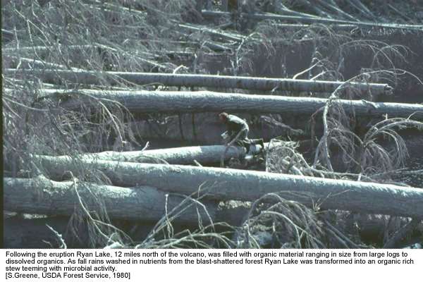
Following
the eruption Ryan Lake, 12 miles north of the volcano, was filled with organic
material ranging in size from large logs to dissolved organics. As fall
rains washed in nutrients from the blast-shattered forest Ryan Lake was
transformed into an organic rich stew teeming with microbial activity.
(S.
Greene, USDA Forest Service, 1980)
Widespread
oxygen depletion occurred as bacterial populations responded to increased nutrient
levels. Within the first year after the eruption the biological system was transformed
from oxygen based system to one dominated by anaerobic heterotrophs (methanogens
that obtain their energy from either hydrogen or acetate).
Anoxic
conditions persisted for a relatively short period of time. Within five years
after the eruption the lakes had mostly returned to normal as wind and seasonal
turnover stirred oxygen into the water column and available nutrients were depleted
as dead microbes and fine sediments settled to the bottom of the lakes.
 Water
samples reveal the tremendous quantity of dissolved organics that leached
into blast zone lakes following the eruption. The dark-colored beaker at left
is from a nutrient-rich, hot spring that flowed from volcanic deposits. The
center beaker is from Coldwater Lake soon after the eruption while the right
beaker is from the lake one year later. The difference in clarity between
the center and right beakers shows how quickly the water cleared as nutrients
were processed by microbial activity and diluted by incoming rain and snow
melt. (Cliff Dahm, Univ. of New Mexico, 1981)
Water
samples reveal the tremendous quantity of dissolved organics that leached
into blast zone lakes following the eruption. The dark-colored beaker at left
is from a nutrient-rich, hot spring that flowed from volcanic deposits. The
center beaker is from Coldwater Lake soon after the eruption while the right
beaker is from the lake one year later. The difference in clarity between
the center and right beakers shows how quickly the water cleared as nutrients
were processed by microbial activity and diluted by incoming rain and snow
melt. (Cliff Dahm, Univ. of New Mexico, 1981)
[back]
Yes.
In 1993, the Washington Dept. of Fisheries and Wildlife (WDFW) found the first
salmonid fish, a rainbow trout, in Spirit Lake. It was 8 inches long and weighed
0.25 pounds. Genetic analysis was performed to attempt to determine the origin
(source population) for this fish. Genetic testing indicated that the fish did
not appear to be related to modern hatchery strains. However, given the limited
sampling data and low resolution of testing, it is impossible to pinpoint the
origin of post-eruption fish in Spirit Lake.
A
second fish was located in Spirit Lake in 1994. This fish was 18 inches long
and weighed 2.75 pounds. Genetic analyses are being completed on this second
fish and the results will be compared to those done on the specimen found in
1993.

Since
1980, biologists have periodically surveyed blast zone lakes to determine
how fish populations responded to the 1980 eruption. Biologists set
gill nets or fish by hook and line for pre-determined intervals to develop
estimates of population levels and size distribution of fish in Monument
lakes.
(J. Nieland, USDA Forest Service, 1981)
[back]
It
is clear that fish could not have survived in the lake following the
debris avalanche and the several months when supply of oxygen in the lake was
depleted by microbial activity (for more information see lakes explanation above).
How fish returned to Spirit Lake remains a mystery. It is likely that fish were
illegally stocked by an angler. Colonization would only have been possible after
the biological recovery of Spirit Lake following the eruption (influx of fresh
water, processing of excess nutrients by bacteria and return of oxygen to its
surface waters). The total number of fish in the lake is unknown at this time.
Further studies are being planned to assess both of these questions.
[back]
The
Monument’s Fish and Wildlife Plan guides the management of fish and wildlife
by the Forest Service and the Washington Dept. of Fisheries and Wildlife within
the 110,000-acre National Volcanic Monument. Even though the Monument Act specifically
allows opportunities for recreational fishing, it was determined that representative
lakes within the blast zone (including Spirit Lake) would be set aside for scientific
research and would not be stocked with fish. "These recommendations recognize
the value of managing for a recreational fishery on some lakes, while allowing
others to remain undisturbed so that natural recovery processes may continue
unimpeded with the option for research studies (Page 41, Monument Fish and Wildlife
Plan, 1989)."
The
Washington State Wildlife Commission has closed Spirit Lake to fishing consistent
with the Monument’s Fish and Wildlife Plan. The Commission recognizes the importance
of Spirit Lake and its surroundings as a unique natural laboratory for research
and for the enjoyment of future generations. This will allow future Monument
visitors to witness the natural recovery process unimpeded by human activity.
The
Spirit Lake basin and valley of North Fork of the Toutle River west to Monument
boundary (Class I Research Area) is closed to public access, except on developed
trails. At this time, the only trail access to Spirit Lake is to the northeastern
shore of the lake via the Harmony Falls Trail located off Forest Road 99. Spirit
Lake is listed as closed for fishing in the Washington Department of Fish and
Wildlife regulation pamphlet. Monument policy clearly indicates that access
to the Spirit Lake basin (and rest of the Class I Research Area) will be on
developed trails only. This will help protect opportunities for long-term research
and allow our future visitors to have the opportunity to observe nature’s own
recovery processes at work in Spirit Lake.

A
biologist displays a cutthroat trout at a high mountain lake north of
Mount St. Helens. This is one of a number of lakes in the volcanic blast
zone that are readily accessible by road or trail and are available
for recreational fishing.
(S. Lanigan, USDA Forest Service, 1991)
[back]
 The
900-foot tall lava dome that formed in the crater between 1980 and 1986 still
retains a considerable amount of heat today. Erosion from flooding and seasonal
run-off has cut deep gullies in the crater floor. Where the groundwater beneath
the dome is exposed hot, mineral rich thermal springs occur. These thermal
areas provide a special habitat for bacteria and other microbial life.
(Tim Lichen, 1990)
The
high nutrient, low oxygen conditions that existed at extreme temperatures following
the eruption and still persist in steam fumaroles and thermal springs draining
the deposits were similar to the conditions that existed during the early stages
of the evolution of life on earth. Microbiologists have repeatedly sampled steam
fumaroles and thermal springs to study primitive bacteria (Archaebacter
spp.) that occur only in volcanic areas and in very high temperature vents deep
on the ocean floor.

Arrows
point to a cross-sectional view of archaebacter as seen through a powerful
electron microscope. Archaen bacteria are only found in high temperature,
high pressure thermal springs and are thought to have been among the earliest
life forms on earth.
(Cliff Dahm, Univ. of New Mexico, 1981)
Mount
St. Helens is a particularly good place to study evolutionary processes because
microbiologists have been able to study these populations from inception and
track their evolution along temperature and chemical gradients that occur at
increasing distances from thermal sources. These gradients may approximate the
same changing conditions (cooling, oxygenation and dilution of nutrient concentrations)
that existed in the wake of widespread volcanism millions of years ago. Scientists
working at Mount St. Helens are able to study microbial responses simultaneously
along gradients that approximate changes that occurred over very long time scales
during the early stages of the development of life on earth.

Primitive
bacteria like archaebacter can be found in the high-temperature, nutrient-rich
thermal springs in the crater. Mats of thermophilic algae and filamentous
bacteria can also be found growing in the warm streams that flow from
the crater floor. Scientists who sample these systems must contend with
a variety of hazards ranging from potentially pathogenic bacteria to near
constant rock fall from the unstable gullies and crater walls. (Tim
Lichen, 1990)
[back]
The
first thing to point out in answering this question is that there is a very
important difference between areas within the boundaries of the legislated National
Volcanic Monument and adjacent lands designated for commodity production. Within
the legislated Monument 110,000 acres are managed by the USDA Forest Service
for research, recreation and most importantly to ensure that natural processes
and features continue to develop substantially unimpeded by human activity.
To examine successes and/or failures in aiding recovery process, one has to
look outside of the legislated National Volcanic Monument in the managed landscape.

In
1982 Congress established the 110,000-acre Mount St. Helens National Volcanic
Monument on the Gifford Pinchot National Forest (red at center is volcanic
crater and Monument boundary is outlined in blue). The Monument is dedicated
to the protection of the unique natural features created by the 1980 eruption
for the benefit of future generations. (USDA Forest Service, 1982)
[back]
Probably
the biggest single factor aiding forest recovery on managed lands has been tree
planting. The Forest Service salvaged 200 million board feet of blown down and
standing dead timber from 10,000 acres. To date nearly 10 million trees have
been planted to reforest more than 14,000 acres of National Forest land. The
survival of planted trees has been very good because forest managers used the
best planting techniques and planting stock available. Survival of planted trees
has generally exceeded 70 percent. Trees planted 10 miles northeast of the volcano
in the Clearwater valley are growing well and many plantations are ready for
pre-commercial thinning.

The
Clearwater Valley is a portion of the volcanic blast zone that is located
outside the Congressionally set-aside Monument, in an area designated
for multiple-use management. This 1981 photograph shows what the area
looked like after the eruption. (USDA Forest Service, 1981)
 With
the exception of designated research plots, wildlife trees and streamside
protection zones the blown down and standing dead trees in the Clearwater
Valley were removed as part of a massive timber salvage and recovery operation.
The green color in this 1987 photograph is from the more than four million
trees that the Forest Service replanted in the Clearwater Valley following
the eruption. Today the trees in these plantations have been pre-commercially
thinned and many trees are over 20 feet tall. (USDA Forest Service,
1987)
With
the exception of designated research plots, wildlife trees and streamside
protection zones the blown down and standing dead trees in the Clearwater
Valley were removed as part of a massive timber salvage and recovery operation.
The green color in this 1987 photograph is from the more than four million
trees that the Forest Service replanted in the Clearwater Valley following
the eruption. Today the trees in these plantations have been pre-commercially
thinned and many trees are over 20 feet tall. (USDA Forest Service,
1987)
[back]
As
far as judging the success of recovery efforts, it’s difficult to say that something
was a mistake, because hindsight provides clarity of vision that didn’t exist
at the time of the emergency response. At the time aerial seeding was approved
no one knew that the roots of surviving native plants were waiting to re-sprout
from the apparently lifeless ash deposits. If managers were faced with the same
situation today, probably the single biggest difference would be that less resources
and effort would be dedicated to erosion control seeding. Today, erosion control
seeding is generally applied on a much more restricted basis and whenever possible
native plant species are used.
[back]
Erosion
played a very important positive role in the recovery of native plants at Mount
St. Helens and, ultimately, the long-term stabilization of blast zone hillslopes.
From the standpoint of ecosystem recovery at St. Helens, erosion should be viewed
as a positive process. The erosion that occurred during the first winter broke
up the overlying ash and enabled many native plants to re-sprout and survive.
In many areas where thick ash deposits prevented re-sprouting plant recovery
was restricted to erosion gullies on steep slopes. These early plant survivors
provided a good seedbed (shade and litter) and thus paved the way for the recovery
of plant life in the blast zone.
The
positive influence of erosion on vegetation recovery is a key lesson learned
for managers of Cascade Volcanoes. Where eruptions bury existing vegetation
and ash deposits are comparatively thin (less than 10 inches) it is very likely
that the surviving native vegetation will be the most dominant force in stabilizing
the hillslopes. In these cases it is unlikely that introduction of non-native
grass species will be a cost effective means of revegetation.

Erosion
gullies formed quickly as runoff from the first fall rains began to
cut through the fresh ash deposits.
(F. Swanson, USDA Forest Service, 1980)

Same
view as preceding picture. Following the first winter erosion gullies had
cut down through the ash exposing the pre-eruption soil surface. The roots
of plants that were lucky enough to have been exposed in gullies were able
to re-sprout and survive. (F. Swanson, USDA Forest Service, 1981)
 Four
years after the eruption willows and other plants are seen growing from the
same erosion gully. In this way, erosion can be viewed as a positive process
that helped to contribute to the survival of native plants that have contributed
to the revegetation and eventual stabilization of blast zone hillslopes.
Four
years after the eruption willows and other plants are seen growing from the
same erosion gully. In this way, erosion can be viewed as a positive process
that helped to contribute to the survival of native plants that have contributed
to the revegetation and eventual stabilization of blast zone hillslopes.
(F. Swanson, USDA Forest Service, 1984)
[back]
When
Mount St. Helens erupted in 1980, an outstanding scientific opportunity was
created, as a result, scientists from across the country and throughout the
world came to Mount St. Helens to observe geologic and biological processes
first hand. The importance of Mount St. Helens as a national resource for scientific
study and public appreciation of volcanic features and processes was recognized
and, in 1982, Congress established the Mount St. Helens National Volcanic Monument
(NVM) on the Gifford Pinchot National Forest. In the 25 years since the eruption,
research has been an important source of basic information for land managers
and for visitors who come to learn about the geology and biology of the area.

The
Monument is an important laboratory for both geologic research and long-term
studies of how nature responds to infrequent, large-scale disturbances.
(U.S. Geologic Survey, 1980)

The
Monument Science program is responsible for promoting the continuation of
long-term studies at the volcano. In order to ensure that natural processes
and features are protected we periodically assesses the status of vegetation
in and around popular trails and visitor facilities. Such baseline monitoring
provides an indication of how well the Monument is meeting its fundamental
preservation objectives. (P. Frenzen, USDA Forest Service, 1994)
[back]
The
Monument Scientist serves as the primary liaison between the Forest Service
and scientists engaged in research at St. Helens. The job of the Monument Scientist
and staff is to document research that has been conducted such that baseline
research sites and information from long-term studies are documented for the
benefit of current and future generations.
Another
important task is to disseminate information about baseline studies to the scientific
community to promote additional opportunities for research in the Monument.
Our objective is to make scientists in the region aware of the tremendous baseline
data available, opportunities for continuing existing research and the establishment
of new studies.
[back]
The
overall level of research at Mount St. Helens is declining as we move away from
the period immediately following the May 18, 1980 eruption. As time goes on
it appears there are fewer investigators actively engaged in research at the
volcano. This is true both in the geologic and the biologic sciences although
the U. S. Geological Survey continues to maintain a substantial presence at
Mount St. Helens. The USGS is involved in a constant monitoring of the volcano
as a means of assessing potential hazards related to volcanic activity and downstream
flooding.
Research
in the Biological Sciences tends to be confined to the efforts of a few dedicated
investigators who are continuing studies that were established during the first
few years following the eruption. In many cases these investigators are continuing
their research at St. Helens in a bootleg fashion, in some cases temporarily
diverting their efforts from other studies to gather additional data from permanent
research installations at the volcano.
The
2004/2005 eruptive activity and growth of a new lava dome has generated significant
renewed interest in research at Mount St. Helens. Efforts are underway
to link opportunities associated with long-term data sets and discoveries made
over the past 25 years with the next generation of scientists. It is truly
an exciting time at Mount St. Helens!
[back]
04/25/00
Mount St. Helens National Volcanic Monument
Gifford Pinchot National Forest