USGS - science for a changing world

USGS Video and Image Gallery

Maps, Imagery, and Publications Hazards Newsroom Education Jobs Partnerships Library About USGS Podcasts/RSS

Home | Photos

Aerial Photo of the Surface Rupture
Thumbnail | Medium | Original
Aerial Photo of the Surface Rupture: No description. (CA, USA)
open embed url Embed this image

Details

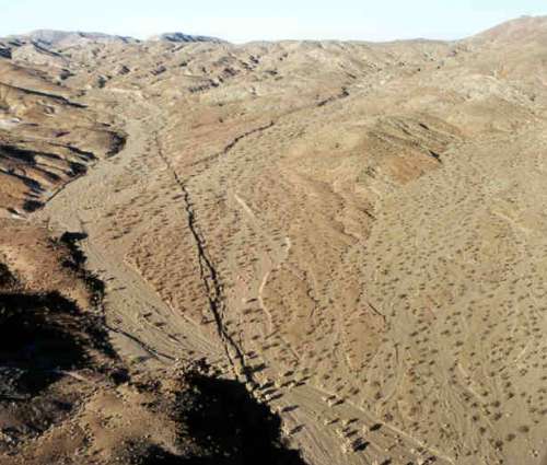
Title: Aerial Photo of the Surface Rupture
Description: No description.
Location: CA, USA
Date Taken: 10/1/1999
Photographer: Katherine Kendrick (), USGS Pasadena
Usage: This image is public domain/of free use. Please refer to the USGS Copyright section for more details.
Source:

File Size (original): JPEG Image - 85.70 KB

Suggest an update to the information/tags?

1999 Hector Mine Earthquake (Set)
Media RSS

Slideshow
Ground Photo of the Surface Rupture: No description. Aerial Photo of the Surface Rupture: No description.
In: Natural Hazards collection

Tags: HectorMine aerial earthquake


Collections

Media RSS

Slideshow
Animals collection

43 photos

Animals

Media RSS

Slideshow
Biology collection

12 photos

Biology

Media RSS

Slideshow
Water collection

39 photos

Water

Media RSS

Slideshow
Climate Change collection

357 photos

Climate Change

Media RSS

Slideshow
Natural Hazards collection

299 photos

Natural Hazards

Media RSS

Slideshow
Native American and Tribal Activities collection

179 photos

Native American and Tribal Activities

Media RSS

Slideshow
Biologic and Environmental Contamination collection

5 photos

Biologic and Environmental Contamination

Media RSS

Slideshow
Natural and Man-Made Structures collection

4 photos

Natural and Man-Made Structures


Accessibility FOIA Privacy Policies and Notices

Take Pride in America logo USA.gov logo U.S. Department of the Interior | U.S. Geological Survey
URL: http://www.usgs.gov/photos/default.asp?p=h41Ogs6FEa_0
Page Contact Information: Image Gallery Webmaster
Page Last Modified: Monday, December 29, 2008