Heavy Rainfall of September 11-14, 2008
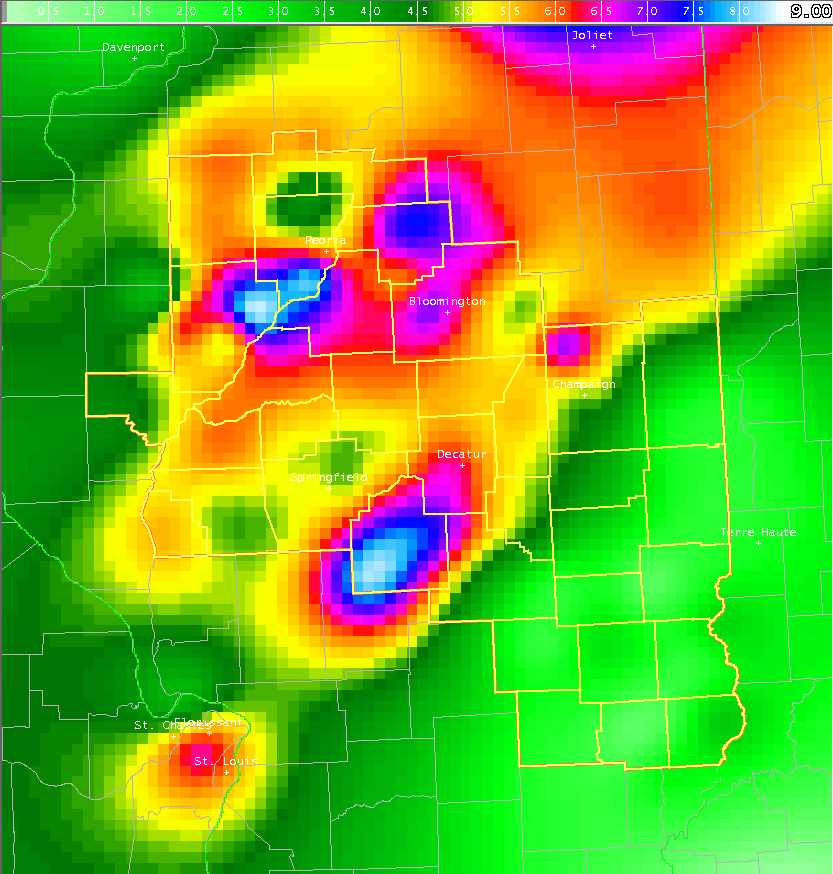
Rainfall map from September 11-14  
Rainfall map from September 11-14 (click image to enlarge)

24-hour rainfall totals ending (click images to enlarge):

24-hour rainfall ending 9 AM 9/12
9 am Sep 12

24-hour rainfall ending 9 am 9/13
9 am Sep 13

24-hour rainfall ending 9 am 9/14
9 am Sep 14

24-hour rainfall ending 9 am 9/15
9 am Sep 15


Midwest Regional Climate Center review of Heavy Rains across the Midwest Sep 11-14

Sep 11-14 Rainfall Image produced by Midwest Regional Climate Center

Excessive rainfall occurred across portions of central Illinois from September 11th through September 14th. The heaviest rain fell along and northwest of a Taylorville, to Lovington, to Champaign line, where many locations picked up between 5 and 8 inches. Further east, the rain was a bit lighter along and east of I-57: however, most areas across east-central and southeast Illinois still received between 1 and 2 inches before the rain finally ended. The precipitation occurred in three distinct waves, culminating in a widespread heavy rain and flooding event associated with the remnants of Hurricane Ike on September 14th.

As high pressure shifted east of the Ohio Valley, a moist southwesterly flow began to set up across central Illinois on September 11th. The combination of a warm front and a weak upper-level disturbance lifting northward through the area led to the development of showers and thunderstorms, particularly across locations west of I-57. The rain began to fall during the late morning hours, then continually re-developed over the same areas along and west of the I-55 corridor. Due to the extended nature of the rain, localized flooding was reported from Morgan and Cass counties northeastward to McLean County.

The warm front lifted northward on September 12th and 13th, shifting the steadiest and heaviest rains into northern Illinois. Meanwhile...much of central and southeast Illinois caught a break from the rain during this time. The respite was short-lived however, as a cold front began to approach from the west during the afternoon of Septemebr 13th. As the front crossed the Mississippi River, rain once again picked up across the Illinois River Valley, eventually reaching the I-55 corridor by evening. Meanwhile, a deep plume of tropical moisture from both the Pacific Ocean and the Gulf of Mexico began to stream northward into the area. Surface dewpoints on the 13th climbed into the upper 60s and lower 70s, while 850mb dewpoints were in the 10° to 15°C range. Both the morning and evening upper air sounding from the Lincoln NWS revealed precipitable water values in excess of 2 inches, which is well above normal for this time of year. As the cold front interacted with this unseasonably moist environment, copious amounts of rain fell across much of west-central and northwest Illinois.

During the overnight hours of September 13th, remnants of Hurricane Ike began lifting northeastward from the lower Mississippi River Valley, further enhancing the rainfall across central Illinois. This system tracked from just south of St. Louis during the early morning of September 14th to northern Indiana by evening. Heavy rain fell along and northwest of this track, with many areas picking up between 2 and 4 inches of rain. Further east, the precipitation was more showery in nature closer to the Indiana border, where much lighter amounts were recorded. As the center of circulation tracked across parts of east-central and southeast Illinois, gusty southerly winds developed. Wind gusts in excess of 40 mph were common along and east of I-57, with the Lawrenceville airport experiencing a wind gust of over 60 mph! Once the remnants of Ike tracked into the Great Lakes, the cold front across west-central Illinois was pulled eastward through the area and the rain finally tapered off and came to an end by the evening of September 14th.

Rainfall totals below were observed.  The column at the left indicates readings from the official Cooperative Observer Network, with the column on the right being observations from the Significant Weather Observer Program.  CoCoRaHS network observations are indicated by the asterisk (*) sign. 

Official Sites Unofficial Sites

Altona                     6.02
Athens 2SW                 4.93
Athens 2N                  5.39
Beardstown                 5.81
Beecher City               2.84
Bloomington 5W             7.08
Bradford 3SSE              5.80
Buffalo                    4.86
Calhoun 5SE                2.58
Casey                      1.27
Chenoa                     6.60
Chillicothe                5.16
Claremont 6N               1.39
Clinton 1SSW               6.13
Congerville 2NW            5.67
Danville Sewage Plant      2.37
Dahinda                    4.13
Decatur Airport            5.90
Decatur Water Plant        6.64
Effingham 3SW              1.98
Effingham SE               1.77
Fisher                     7.30
Flora 5NW                  2.31
Galesburg                  5.09
Germantown Hills           8.50
Havana                     5.82
Hidalgo 3SW                2.96
Hoopeston                  5.31
Hutsonville                3.14
Jacksonville               4.86
Jacksonville WLDS          4.77
Kincaid 3W                 8.50
Knoxville                  5.77
Lawrenceville              3.67
Lawrenceville Airport      3.51
Lincoln                    5.81
Loami 3SSW                 4.98
Lovington                  5.08
Mackinaw                   6.19
Mahomet                    5.66
Marietta                   6.49
Martinsville 10S           2.27
Mason City 2N              6.30
Mattoon                    2.90
Minonk                     7.27
Monticello                 5.56
Morrisonville              8.43
Morton                     6.22
Mount Pulaski              5.10
Moweaqua 2S                7.21
Newman 3W                  4.17
Neoga                      1.85
Neoga 4NW                  2.02
Normal 4NE                 6.22
Ogden                      3.70
Olney 2S                   1.27
Pana 3E                    4.97
Palestine                  2.40
Paris                      2.12
Peoria Airport             8.25
Peoria Airport 3SW         6.84
Peoria 5NW                 5.54
Petersburg 2SW             7.74
Prairie City 2S            3.59
Princeville 2W             4.17
Rankin                     5.40
Roanoke                    7.44
Robinson                   1.81
Rushville                  4.71
Saybrook 2N                4.91
Shelbyville Dam            3.77
Sherman                    4.77
Sidell 5NW                 2.51
Springfield Airport        5.22
Springfield CWLP           3.67
Springfield NE             4.64
St David                   8.19
Ste Marie                  2.30
Sullivan 3S                4.70
Taylorville 2SW            8.04
Toulon                     5.37
Trimble 1E                 2.49
Tuscola                    4.27
Urbana IL Water Survey     4.63
Virginia                   5.99
Urbana WILL                5.18
Winchester                 5.63

Arthur                    6.32
Beardstown                6.60
Birds                     2.12
Bismarck 3W               3.37
Bloomington 1SW           6.16
Bloomington               6.02
Boody                     6.25
Canton                    5.32
Champaign 3SW (*)         4.86
Charleston                2.26
Chatham                   4.59
Chestnut 2S               4.62
Cisco 2NE                 5.72
Cisne                     1.52
Clinton                   6.22
Delavan                   7.30
DeLand                    5.42
Dunlap 2SE                7.98
East Peoria               5.82
Effingham                 1.71
Flora                     1.25
Galesburg                 4.56
Galesburg 1N              4.35
Germantown Hills 2N       8.03
Goodfield                 5.95
Greenview 3S              8.12
Gridley                   6.79
Henry                     3.61
Heyworth                  5.89
Homer 2N                  3.50
Jacksonville              3.69
Jerome                    4.63
Lakewood                  3.78
Lane                      5.52
Leroy                     5.01
Lovington                 5.28
Mackinaw 5SW              6.47
Manito                    5.53
Martinsville 2NE          1.37
Mattoon                   2.75
Monticello                5.51
Morton                    6.22
Mossville 1S              6.45
Neoga                     1.90
Newton 8NW                2.28
Oakland 7N                3.28
Olney                     1.33
Peoria                    8.58
Peoria Heights            7.27
Petersburg                5.22
Petersburg 8E             5.52
Philadelphia 2S           5.99
Philo                     3.31
Riverton                  5.01
Rushville                 5.10
Shelbyville               1.88
South Jacksonville (*)    4.28
Springfield 4W            5.43
Sumner                    2.40
Watson                    2.30


  • NOAA National Weather Service
  • Central Illinois Weather Forecast Office
  • 1362 State Route 10
  • Lincoln, IL 62656
  • 217-732-3089 (8:30 am to 4 pm weekdays)
  • Page Author: ILX Webmaster
  • Web Master's E-mail: w-ilx.webmaster@noaa.gov
  • Page last modified: September 18th 2008 9:38 PM
USA.gov is the U.S. government's official web portal to all federal, state and local government web resources and services.