The University of Georgia´s Center for Invasive Species and Ecosystem Health has developed an Early Detection and Distribution Mapping System, or EDDMapS, to provide a more accurate picture of the distribution of invasive species. EDDMapS will allow land managers, agencies and others to set priorities for early detection and rapid response (EDRR), as well as formulate overall invasive plant management action plans.
It was designed as a tool to develop more complete local, state and regional level distribution data of invasive species, identify "leading edge" ranges of new invasive threats, provide a means of implementing EDRR, and help corroborate threats and refine invasive species lists and management priorities.
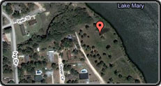
Quickly Enter or Select on a Map the Location of Invasive Species in Your Area.
Start Reporting
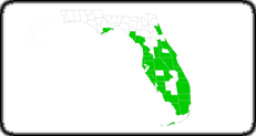
Select a Species to View the Distribution both at the County level and Point locations.
Explore Distribution
View Publications and Images to Learn how to Correctly Identify and Manage Invasive Species.
Learn More