|
|
Country: | United States | |
| Subregion Name: | Aleutian Islands | ||
| Volcano Number: | 1101-24- | ||
| Volcano Type: | Stratovolcano | ||
| Volcano Status: | Historical | ||
| Last Known Eruption: | 2008 | ||
| Summit Elevation: | 1730 m | 5,676 feet | |
| Latitude: | 52.825°N | 52°49'30"N | |
| Longitude: | 169.944°W | 169°56'38"W | |
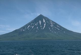
| Beautifully symmetrical Mount Cleveland stratovolcano is situated at the western end of the uninhabited, dumbbell-shaped Chuginadak Island. It lies SE across Carlisle Pass strait from Carlisle volcano and NE across Chuginadak Pass strait from Herbert volcano. Cleveland is joined to the rest of Chuginadak Island by a low isthmus. The 1730-m-high Mount Cleveland is the highest of the Islands of the Four Mountains group and is one of the most active of the Aleutian Islands. The native name for Mount Cleveland, Chuginadak, refers to the Aleut goddess of fire, who was thought to reside on the volcano. Numerous large lava flows descend the steep-sided flanks of the volcano. It is possible that some 18th-to-19th century eruptions attributed to Carlisle should be ascribed to Cleveland (Miller et al., 1998). In 1944 Cleveland produced the only known fatality from an Aleutian eruption. Recent eruptions from Mount Cleveland have been characterized by short-lived explosive ash emissions, at times accompanied by lava fountaining and lava flows down the flanks. | |||