|
|
Country: | Japan | |
| Subregion Name: | Ryukyu Islands (Japan) | ||
| Volcano Number: | 0802-03= | ||
| Volcano Type: | Stratovolcanoes | ||
| Volcano Status: | Historical | ||
| Last Known Eruption: | 2008 (in or after) | ||
| Summit Elevation: | 799 m | 2,621 feet | |
| Latitude: | 29.635°N | 29°38'5"N | |
| Longitude: | 129.716°E | 129°42'58"E | |
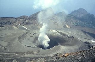
| The 8-km-long, spindle-shaped island of Suwanose-jima in the northern Ryukyu Islands consists of an andesitic stratovolcano with two historically active summit craters. Only about 50 persons live on the sparsely populated island. The summit of the volcano is truncated by a large breached crater extending to the sea on the east flank that was formed by edifice collapse. Suwanose-jima, one of Japan's most frequently active volcanoes, was in a state of intermittent strombolian activity from On-take (Otake), the NE summit crater, that began in 1949 and lasted until 1996, after which periods of inactivity lengthened. The largest historical eruption took place in 1813-14, when thick scoria deposits blanketed residential areas, and the SW crater produced two lava flows that reached the western coast. At the end of the eruption the summit of On-take collapsed forming a large debris avalanche and creating the horseshoe-shaped Sakuchi caldera, which extends to the eastern coast. The island remained uninhabited for about 70 years after the 1813-1814 eruption. Lava flows reached the eastern coast of the island in 1884. | |||