|
|
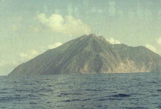
Country: | Indonesia | |
| Subregion Name: | Lesser Sunda Islands (Indonesia) | ||
| Volcano Number: | 0604-26= | ||
| Volcano Type: | Stratovolcano | ||
| Volcano Status: | Historical | ||
| Last Known Eruption: | 2008 | ||
| Summit Elevation: | 748 m | 2,454 feet | |
| Latitude: | 7.792°S | 7°47'30"S | |
| Longitude: | 123.579°E | 123°34'45"E | |
| The small isolated island of Batu Tara in the Flores Sea about 50 km north of Lembata (fomerly Lomblen) Island contains a scarp on the eastern side similar to the Sciara del Fuoco of Italy's Stromboli volcano. Vegetation covers the flanks of Batu Tara to within 50 m of the 748-m-high summit. Batu Tara lies north of the main volcanic arc and is noted for its potassic leucite-bearing basanitic and tephritic rocks. The first historical eruption from Batu Tara, during 1847-52, produced explosions and a lava flow. | |||