|
|
Country: | Papua New Guinea | |
| Subregion Name: | New Britain | ||
| Volcano Number: | 0502-14= | ||
| Volcano Type: | Pyroclastic shield | ||
| Volcano Status: | Historical | ||
| Last Known Eruption: | 2008 (in or after) | ||
| Summit Elevation: | 688 m | 2,257 feet | |
| Latitude: | 4.271°S | 4°16'15"S | |
| Longitude: | 152.203°E | 152°12'10"E | |
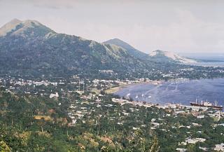
| The low-lying Rabaul caldera on the tip of the Gazelle Peninsula at the NE end of New Britain forms a broad sheltered harbor utilized by what was the island's largest city prior to a major eruption in 1994. The outer flanks of the 688-m-high asymmetrical pyroclastic shield volcano are formed by thick pyroclastic-flow deposits. The 8 x 14 km caldera is widely breached on the east, where its floor is flooded by Blanche Bay and was formed about 1400 years ago. An earlier caldera-forming eruption about 7100 years ago is now considered to have originated from Tavui caldera, offshore to the north. Three small stratovolcanoes lie outside the northern and NE caldera rims of Rabaul. Post-caldera eruptions built basaltic-to-dacitic pyroclastic cones on the caldera floor near the NE and western caldera walls. Several of these, including Vulcan cone, which was formed during a large eruption in 1878, have produced major explosive activity during historical time. A powerful explosive eruption in 1994 occurred simultaneously from Vulcan and Tavurvur volcanoes and forced the temporary abandonment of Rabaul city. | |||