Skip Navigation
NOAA
weather.gov
National Weather Service Weather Forecast Office
Paducah, KY
Search for:
NWS
All NOAA
Home
Site Map
News
Organization
Local forecast by
"City, St" or Zip Code
Current Hazards
Watches / Warnings
Outlooks
U.S. Hazards
Hurricane Info
eSpotter
Severe Weather Briefings
Severe Weather Information
Current Conditions
Observations
Satellite Images
Rivers & Lakes AHPS
Precip Estimate
Snow Cover
CoCoRaHS Summary
Radar Imagery
Local Radar
Nationwide
Evansville
Hopkinsville
Forecasts
Activity Planner
Local Area
Aviation
Fire Weather
Graphical
Text Products
Audio Products
Rivers / Hydrology
AHPS / River Info
River Forecasts
Current Stages
Climate
Local
National
More...
Weather Safety
StormReady
Weather Radio
EMWIN
SKYWARN spotters
Local Information
Our Office
Coop Observer
Service Guide
Our Warning Area
Customer Service Workshop Findings
Emergency Manager Page
Education/Training
Science/Research
Weather Education
Past Weather Events
1925 Tri-State Tornado
1982 Marion Tornado
1957 Carter County MO Tornado
Model data
Contact Us
Webmaster
Feedback
FORECAST-AT-A-GLANCE
PADUCAH
This
Afternoon
Partly
Sunny
Hi
74 °F
Tonight
Mostly
Cloudy
Lo
52 °F
Sunday
Chance
Showers
Hi
72 °F
Sunday
Night
Slight Chc
Showers
Lo
50 °F
Monday
Partly
Sunny
Hi
72 °F
Monday
Night
Partly
Cloudy
Lo
49 °F
EVANSVILLE
This
Afternoon
Partly
Sunny
Hi
73 °F
Tonight
Mostly
Cloudy
Lo
50 °F
Sunday
Slight Chc
Showers
Hi
71 °F
Sunday
Night
Mostly
Cloudy
Lo
49 °F
Monday
Partly
Sunny
Hi
72 °F
Monday
Night
Partly
Cloudy
Lo
49 °F
CAPE GIRARDEAU
This
Afternoon
Partly
Sunny
Hi
72 °F
Tonight
Mostly
Cloudy
Lo
50 °F
Sunday
Chance
Showers
Hi
71 °F
Sunday
Night
Slight Chc
Showers
Lo
48 °F
Monday
Partly
Sunny
Hi
72 °F
Monday
Night
Partly
Cloudy
Lo
49 °F
TODAY'S QUAD STATE OUTLOOK
Thunderstorms
Hail
Strong Winds
Heavy Rain
Lightning
Tornadoes
None
Low
Mod
High
Click for more detail
CURRENT CONDITIONS
LOCATION
TIME[cst]
WEATHER
TEMP
DEWPT
HUMIDITY
WIND
PRESSURE
Cape Girardeau, MO
12:53
Fair
68ºF
51ºF
55%
NW 10 mph
30.05 in
Carbondale, IL
12:55
Overcast and Windy
64ºF
64ºF
100%
N 32 G 49 mph
29.51 in
Evansville, IN
12:54
Fair
68ºF
49ºF
51%
NW 13 G 21 mph
30.01 in
Mount Carmel, IL
13:45
Mostly Cloudy
66ºF
50ºF
56%
NW 12 G 18 mph
30.02 in
Mount Vernon, IL
13:35
Mostly Cloudy
64ºF
46ºF
52%
NW 7 mph
30.06 in
Owensboro, KY
12:56
Fair
69ºF
51ºF
53%
W 12 mph
30.00 in
Paducah, KY
12:53
Fair
71ºF
51ºF
49%
NW 9 mph
30.02 in
Poplar Bluff, MO
12:53
Fair
69ºF
48ºF
47%
NW 8 mph
30.04 in
CLICK ON LOCATION FOR THREE DAYS OF OBSERVATIONS
CLIMATE
YESTERDAY'S CLIMATE STATISTICS
PADUCAH
EVANSVILLE
OBSERVED
HIGH: 76ºF at 350PM
LOW: 61ºF at 444AM
HIGH: 74ºF at 529PM
LOW: 60ºF at 1104PM
NORMAL
HIGH: 75ºF
LOW: 52ºF
HIGH: 75ºF
LOW: 51ºF
LAST YEAR
HIGH: 75ºF
LOW: 58ºF
HIGH: 72ºF
LOW: 59ºF
RECORDS
HIGH: 90ºF in 1986
LOW: 36ºF in 1944
HIGH: 90ºF in 1897
LOW: 38ºF in 1989
PRECIP
0.83" YESTERDAY
2.51" MONTH TO DATE
1.37" YESTERDAY
2.22" MONTH TO DATE
SUNRISE
&
SUNSET
MAY 9
SUNRISE: 552AM SUNSET: 751PM
MAY 10
SUNRISE: 551AM SUNSET: 752PM
MAY 9
SUNRISE: 545 SUNSET: 749PM
MAY 10
SUNRISE: 544AM SUNSET: 750PM
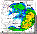
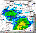
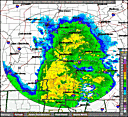
RADARS
PADUCAH RADAR
STANDARD
ENHANCED
EVANSVILLE RADAR
STANDARD
ENHANCED
HOPKINSVILLE RADAR
STANDARD
ENHANCED
QUICKLINKS
WEATHER
CLIMATE
RIVERS
SEVERE WEATHER INFORMATION
HAZARDOUS WEATHER OUTLOOK
REGIONAL WEATHER SUMMARY
STORM REPORT GRAPHIC
SEVERE WEATHER BRIEFS
E-SPOTTER
PAST WEATHER EVENTS
PAST 24 HOURS
LOCAL
NATIONAL
OBSERVED RIVER STAGES
FORECAST RIVER STAGES
RIVER INFORMATION
National Weather Service
Paducah, KY Weather Forecast Office
8250 Kentucky Highway 3520
West Paducah, KY 42086-9762
270-744-6440
Page Author: PAH Webmaster
Web Master's E-mail:
w-pah.webmaster@noaa.gov
Page last modified: March 11th 2008 4:54 PM
Disclaimer
Credits
Glossary
Privacy Policy
About Us
Career Opportunities