|
|
Country: | India | |
| Subregion Name: | Andaman Islands | ||
| Volcano Number: | 0600-01= | ||
| Volcano Type: | Stratovolcano | ||
| Volcano Status: | Historical | ||
| Last Known Eruption: | 2008 | ||
| Summit Elevation: | 354 m | 1,161 feet | |
| Latitude: | 12.278°N | 12°16'40"N | |
| Longitude: | 93.858°E | 93°51'30"E | |
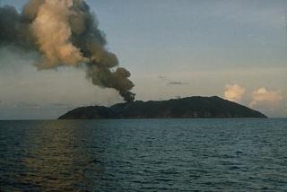
| Barren Island, a possession of India in the Andaman Sea about 135 km NE of Port Blair in the Andaman Islands, is the only historically active volcano along the N-S-trending volcanic arc extending between Sumatra and Burma (Myanmar). The 354-m-high island is the emergent summit of a volcano that rises from a depth of about 2250 m. The small, uninhabited 3-km-wide island contains a roughly 2-km-wide caldera with walls 250-350 m high. The caldera, which is open to the sea on the west, was created during a major explosive eruption in the late Pleistocene that produced pyroclastic-flow and -surge deposits. The morphology of a fresh pyroclastic cone that was constructed in the center of the caldera has varied during the course of historical eruptions. Lava flows fill much of the caldera floor and have reached the sea along the western coast during historical eruptions. | |||