|
|
Country: | Guatemala | |
| Subregion Name: | Guatemala | ||
| Volcano Number: | 1402-09= | ||
| Volcano Type: | Stratovolcano | ||
| Volcano Status: | Historical | ||
| Last Known Eruption: | 2008 (in or after) | ||
| Summit Elevation: | 3763 m | 12,346 feet | |
| Latitude: | 14.473°N | 14°28'22"N | |
| Longitude: | 90.880°W | 90°52'49"W | |
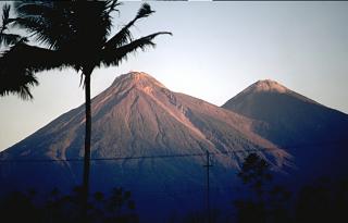
| Volcán Fuego, one of Central America's most active volcanoes, is one of three large stratovolcanoes overlooking Guatemala's former capital, Antigua. The scarp of an older edifice, Meseta, lies between 3763-m-high Fuego and its twin volcano to the north, Acatenango. Construction of Meseta volcano dates back to about 230,000 years and continued until the late Pleistocene or early Holocene. Collapse of Meseta volcano may have produced the massive Escuintla debris-avalanche deposit, which extends about 50 km onto the Pacific coastal plain. Growth of the modern Fuego volcano followed, continuing the southward migration of volcanism that began at Acatenango. In contrast to the mostly andesitic Acatenango volcano, eruptions at Fuego have become more mafic with time, and most historical activity has produced basaltic rocks. Frequent vigorous historical eruptions have been recorded at Fuego since the onset of the Spanish era in 1524, and have produced major ashfalls, along with occasional pyroclastic flows and lava flows. | |||