Skip Navigation Linkswww.weather.gov 
Go to NOAA's main page Go to the NWS Southern Region pageNational Weather Service Forecast Office

Tallahassee, FL
    

Local weather forecast by
"City, St" or zip code
  
Forecasts & Current Weather


Latest Surface Analysis (Click on the map for more options)

Click on map for additional options.

Latest Tallahassee Upper Air Sounding (Click on the diagram for more options)

Click on diagram for additional options.

In addition to issuing short-fused warnings (tornado, severe thunderstorm, flash flood), the National Weather Service in Tallahassee issues routine 7-day public forecasts, 5-day marine forecasts, daily and monthly climate reports, and specialized forecasts for our aviation and fire weather communities in the Eastern Florida Panhandle, the Florida Big Bend, Southeast Alabama, and Southwest & South Central Georgia. We also issue longer-term watches and warnings for hazards such as dense fog, excessive heat, freezes, high winds, wind chill and other winter weather.
Geneva Escambia Houston Covington Dale Coffee Conecuh Henry Butler Crenshaw Pike Barbour Bullock Lowndes Montgomery Coastal Okaloosa Coastal Okaloosa Coastal Okaloosa Wakulla Alachua Union Lafayette Suwannee Columbia Liberty Calhoun Hamilton Madison Jefferson Leon Gadsden Coastal Walton Washington Inland Walton Inland Okaloosa Holmes Jackson Levy Dixie Franklin Franklin Franklin Franklin Taylor Gilchrist Bay Gulf Bay Bay Gulf Lowndes Brooks Thomas Grady Seminole Decatur Clinch Lanier Miller Colquitt Cook Atkinson Mitchell Baker Ware Berrien Early Tift Calhoun Dougherty Echols Clay Coffee Ben Hill Turner Worth Lee Randolph Terrell Jeff Davis Quitman Crisp Wilcox Telfair Sumter Webster Stewart Wheeler Montgomery Dodge Bacon Irwin click here for the latest warning information.  Click on the map for a forecast. pan north to Northern and Central Georgia pan northeast to the Southern end of South Carolina and Eastern Georgia pan east to Northeast Florida and Southeast Georgia pan southeast to West Central Florida pan west to Mobile - Pensacola pan northwest to Northern Alabama zoom out Coastal waters from  Suwannee River to Apalachicola,FL out to 20 nm Coastal waters from  Suwannee River to Apalachicola,FL out to 20 nm Coastal waters from Destin to Pensacola, FL out 20 nm Coastal waters from Tarpon Springs to Suwannee River out 20 nm Waters from Apalachicola to Destin, FL extending from 20 to 60 nm Waters from  Suwannee River to Apalachicola,FL extending from 20 to 60 nm Waters from Destin to Pensacola, FL extending from 20 nm to 60 nm Middle Gulf between 85 West and 90 West Coastal waters from Apalachicola to Destin, FL out to 20nm Coastal waters from Apalachicola to Destin, FL out to 20nm Coastal waters from Apalachicola to Destin, FL out to 20nm


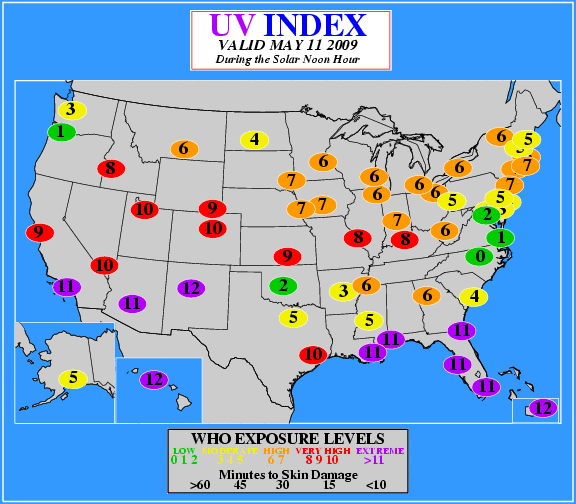
Latest UV Index Forecast (Click on the map for more options)

Click on map for additional options.

watches & warnings
warnings & advisories Florida Georgia Alabama Nationwide
watches Florida Georgia Alabama Nationwide

weather by state

satellite and radar imagery

river and precipitation data tides and almanac

national and international


National Weather Service
Tallahassee Weather Forecast Office
Love Building
Florida State University
Tallahassee, FL 32306-4509

Phone: (850) 942-8833 (now answered 24/7)
Recorded Weather Info Line: (850) 942-8851
FAX: (850) 942-8850

Page Author: NWS Tallahassee, FL

Disclaimer
Credits
Glossary
Comments/Feedback
Privacy Policy
About Our Organization
Career Opportunities

We are an affiliate organization of the
Banner that says Capital Area Citizens Corps and links to their web page.