Severe Thunderstorms and Tornadoes

 |
| Photo: NWS Flagstaff |
What is a Thunderstorm and How Does it Form?
A thunderstorm is a local storm that produces lightning and
thunder . It can consist of a single cumulonimbus
cloud , a cluster of clouds, or a line of clouds. Thunderstorms form when moist,
unstable air near the surface is lifted. This lifting can be caused by thermals generated
from a strongly heated surface, the forcing of air upward along a frontal surface or
terrain surfaces, or by the upward motion produced by winds converging near the surface.
Thunderstorms are generally transient phenomena that last anywhere from 10 minutes to
several hours. Thunderstorms are often accompanied by showery rain and gusty winds, and
may also bring hail or snow. Thunderstorms occur most frequently during summer, but they
are not unknown in the winter when thunder can sometimes be heard during intense snowstorms.
Thunderstorms are categorized as ordinary and severe. Severe thunderstorms generally
last longer than ordinary thunderstorms and can produce very strong winds, flooding, hail,
and/or tornadoes. Ordinary thunderstorms are generally short lived and generally do not
produce very strong winds or large hail.
What is the Life Cycle of a Typical Thunderstorm?
Many thunderstorms typically undergo a three-stage life cycle. In the
cumulus stage (a), warm, moist air rises in a buoyant plume or in a series of
convective updrafts. When the air becomes saturated, a convective cloud begins to grow. As
the warm air plume continues to rise, more water vapor condenses, releasing the latent heat
of vaporization. This heat enhances the convection and makes the buoyant plume grow faster.
The cloud edges during this stage are sharp and distinct, indicating that the cloud is
composed primarily of water droplets. The convective cloud continues to grow upward,
eventually growing above the freezing level where supercooled water droplets and ice
crystals coexist.
The mature stage (b) of a thunderstorm is characterized by the presence of both
updrafts and downdrafts within the cloud. The downdrafts are initiated by the downward drag
of falling precipitation. The downdraft is strengthened by evaporative cooling, as the rain
falling with the downdraft enters drier air below the cloud base and evaporates. This cold
descending air in the downdraft will often reach the ground before the precipitation.
Cloud to ground lightning usually begins when the precipitation
first falls from the cloud base. During this phase of the life cycle, the top of the cloud
will start to flatten out, forming an anvil shape.
The decaying stage (c) of a thunderstorm is characterized by downdrafts throughout
the entire cloud. Decay often begins when the supercooled cloud droplets freeze and the
cloud becomes glaciated, which means that it contains ice crystals. Glaciation typically
first appears in the anvil, which becomes more pronounced in this stage. The glaciated
cloud appears filmy, or diffuse, with indistinct cloud edges. The cloud begins to collapse
because no additional latent heat is released after the cloud droplets freeze, and because
the shadow of the cloud and rain cooled downdrafts reduce the temperature below the cloud.
The decay of a thunderstorm can also be initiated when the precipitation within the storm
becomes too heavy for the updrafts to support, when the source of moisture is cut off, or
when lifting ceases.
 |
The three stages of the life cycle of air mass thunderstorms: (a) cumulus stage,
(b)
mature stage, and (c) decaying stage. Arrows indicate wind directions.
(Adapted from Byers
and Braham, 1949) |
So What Makes a Thunderstorm Severe?
The structure and life cycle of severe thunderstorms are fundamentally different from
general thunderstorms. As mentioned above, general thunderstorms are composed of updrafts
which become downdrafts as the precipitation begins to fall and the updraft can no longer
support the weight of the precipitation. The updrafts in severe thunderstorms, in contrast,
tend to be tilted by strong vertical wind shear. Wind shear simply means that the wind
changes direction or increases significantly in speed with height. Since the updrafts tilt
over the downdrafts, this allows heavy precipitation to fall out of the updrafts and into
the downdrafts. The updrafts can thus continue without having to support heavy suspended
precipitation.
Although rain, hail, lightning, and winds can be associated with any thunderstorm,
severe thunderstorms tend to produce more precipitation, larger hail, more lightning, and
stronger winds. Severe thunderstorms can occasionally spawn tornadoes and funnel clouds.
In Arizona, our most significant danger from severe thunderstorms is in the form of
strong damaging winds. Strong, localized downdrafts, called downbursts, often occur
along the leading edge of a severe thunderstorm and its associated rainfall. These cool,
gusty winds result when downdrafts within the storm are strengthened by evaporative cooling
as precipitation falls into the drier air below the cloud base and evaporates. When the
downburst hits the ground, it fans out radially in all directions. Winds associated with
downbursts can easily exceed 58 mph, which would categorize it as a severe thunderstorm,
according to National Weather Service standards.
Watches and Warnings
 |
Some near golfball size hail, the day after the event.
Prescott Valley, Sept. 1999 (Photo: NWS Flagstaff) |
The National Weather Service monitors thunderstorms in Arizona with doppler radar, satellite imagery, and
with the help of trained weather spotters. When winds from thunderstorms are expected to be 58 mph or
greater, the National Weather Service issues severe thunderstorm
warnings. These warnings are issued for small areas and are only valid for as long as the winds are expected
to exceed 58 mph. The warnings are broadcast on NOAA Weather Radio as well as commercial tv and radio
stations using the emergency alert system.
Severe thunderstorm warnings are also issued for thunderstorms that
produce hail three quarter inch in diameter or greater. The climate
of Northern Arizona is such that much of the hail that occurs is
one-quarter to one-half inch in diameter. However, several times in
the summer, strong thunderstorms develop that do produce hail three
quarter inch in diameter or greater. Hail this size can be painful to
persons caught outside and may cause damage to property. A complex of
severe thunderstorms hit Yavapai County near Prescott in September
1999, and produced hail over two inches in diameter, which caused
several thousands of dollars in damage to personal property. Although
many of the hail occurrences in Northern Arizona is in the one-quarter
to one-half inch range, it can cause problems to motorists and people
outdoors. There have been several cases in the past where small hail
has accumulated to 3 or 4 inches deep on the highways, and had to be
removed by snow plows.
Severe thunderstorm watches are issued on rare occasions in Northern Arizona. These watches are issued
when the National Weather Service expects several severe thunderstorms to affect an area. When a severe
thunderstorm watch is issued, persons should pay attention to the weather and be prepared for strong winds
or hail if a thunderstorm develops near them.
How do Tornadoes Form?
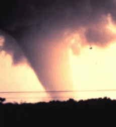
|
| Photo: NOAA |
A tornado is a vortex of air rising into a cloud. As mentioned, in their early and
mature stages, all thunderstorms are characterized by the updraft, which supply the storm
with warm, humid air for continued growth. But, in some cases, the column of rising air can
give rise to a rapidly spinning vortex, which can become a funnel cloud, or a tornado.
Winds in most tornadoes blow at 100 mph or less, but in a few cases, the vortex can become
a strong tornado with winds of up to 300 mph.
Often, a tornado forms along the edge of the updraft, next to the downdraft that is
formed from falling precipitation and rain cooled air. As mentioned above, in severe
thunderstorms the updraft and downdraft remain separate allowing for more optimal tornado
generation. To keep the updraft and downdraft separate, wind shear is required. Strong
tornadoes tend to form in environments where winds at all levels are not only strong, but
also turn in height in a clockwise, or veering, direction. As the downdraft hits the
ground, the air is forced to spread outward away from the downdraft. This air acquires
spin, which under optimal conditions, can be acted on by the updraft and stretched into the
cloud, developing into a funnel cloud. If this funnel cloud reaches the ground, it
becomes a tornado. This is one mechanism through which tornadoes can form.
Tornadoes can form in other ways as well. One of the key questions that scientists are
trying to answer about tornadoes is why updrafts in some thunderstorms become these
twisting whirlwinds, while those in apparently similar thunderstorms do not. Many field
studies have occurred which try to increase our knowledge of how tornadoes form. For more
information on one of these projects, click on the Vortex Project.
While Arizona does not see tornadoes of the magnitude and frequency of
the Midwest, there are typically a few tornadoes in Northern Arizona every
summer. Most of the tornadoes in Northern Arizona are very weak producing
winds less than 70 mph and lasting 5 minutes or less. An average of 4
tornadoes touch down in Arizona each year. Two tornadoes struck Yavapai
County near Prescott in September 1999 which caused several thousands of
dollars in damage to personal property.
| Tornado Safety Tips |
- Most homes and businesses in Northern Arizona do not have
basements, but there are other relatively safe places to hide.
Go into a windowless central room, closet, or bathroom. Crouch in a
corner while you cover your head with your hands.
|
- In a business, move to an interior hallway or stairwell. Put as
many walls between you and the tornado as possible.
|
- Avoid areas with wide-spanning roofs, like gymnasiums or auditoriums.
|
- If caught in the open, crouch in a low lying area and cover your head with your hands.
|
<
| |


