What are El Niño and La Niña?
El Niño and La Niña are extreme phases of a naturally occurring climate cycle referred to as
El Niño/Southern Oscillation (ENSO). Both El Niño and La Niña refer to large-scale changes in
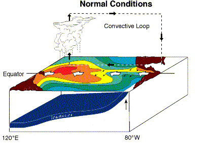
sea-surface temperatures (SSTs) across the central and eastern tropical Pacific Ocean. During ENSO neutral years, SSTs off
of South America's tropical west coast are in the 60s and 70s due to upwelling along the coast. Meanwhile, further west, SSTs
warm into the 80s across the central and western Pacific. During the positive phase of ENSO, known as El Niño, this "warm
pool" of water in the western and central equatorial Pacific expands eastward to the South American coast. During the negative
phase of ENSO, known as La Niña, upwelling is stronger than normal causing below normal SSTs to expand westward into
the central equatorial Pacific Ocean. For more on these extreme phases of the climate cycle please refer to the Science
Corner links at the bottom of this web page.
So how can sea surface temperatures in the tropical Pacific Ocean have any bearing on
the weather that occurs in northern Arizona?
Due to unequal heating of the equatorial regions versus the polar regions, temperature differences occur between the
equatorial regions (receiving more heat energy) and the poles (receiving far less heat energy). This inbalance requires
circulation patterns to develop which move heat from the tropics toward the poles, and move cool air from the poles toward
the equator. Primary atmospheric mechanisms to reduce these temperature differences between the equator and poles include
areas of low and high pressure systems and the development of clouds and winds to transport heat around the hemispheres.
Persistant winds blowing on the ocean can cause upwelling and downwelling along coast lines, along with developing
circulations throughout the oceans themselves. These circulation patterns, both in the atmosphere and the oceans, allow
for heat energy to be transported throughout the Earth system. The ocean plays a large role in the atmospheric
circulation pattern which determines our weather and our climate.
The jetstream is a fast flowing ribbon of air in the atmosphere that tends to be the primary mechanism which determines
the weather pattern in a particular location. In the Northern Hemisphere, cold air tends to be located to the north of the
jetstream with relatively warmer air located to the south of the jetstream. Thus, the jetstream tends to be located over
areas where there is a strong contrast in temperature, which in weather jargon is called a front. When the right conditions
exist, an area of low pressure can develop along the front, and act to relieve the temperature contrast by moving warm
air from the south ahead of the low pressure system and moving colder air from the north behind the low pressure system. Low
pressure systems are also the primary mechanism for the development of large areas of clouds and precipitation.
Because the jet stream is the "steering current" for areas of low pressure, and also the primary location for the development
of low pressure systems, in order to have stormy weather, you usually need to be near the jetstream.
Well, these temperature contrasts don't only exist over the land, but also exist in the oceans. As mentioned above,
temperature contrasts occur in the tropical Pacific Ocean and differ during each phase of ENSO. It has been found that
persistent thunderstorms primarily develop over warm waters, especially with temperatures greater than about 80 degrees F.
This is the primary reason why hurricanes only develop in certain regions of the ocean at certain times of the year. In
ENSO neutral years, as shown in the figure above, warm water is located primarily over western and central portions of the
tropical Pacific Ocean, which keeps the persistent thunderstorm activity over this region. Anyone who has traveled to
Indonesia and the islands of the western Pacific has experienced the typical daily thunderstorm activity that occurs
there due to these warm waters. The persistent nature of these thunderstorms affects the atmospheric circulation by
enhancing and anchoring the jetstream in a particular location, just like a rock in a creek creates patterns in the water
downstream from it. The jetstream will then affect locations further downstream, such as the United States, with rain and
snow storms during the winter season.

During El Niño events, the warm pool of water, which typically is located over only the western portions of
the Pacific Ocean, spreads eastward toward South America. Eventually it covers the entire Pacific Ocean along the equator.
This results in an eastward movement of persistent thunderstorm activity, which in turn leads to the energy from these
thunderstorms shifting the jetstream pattern across the Pacific Ocean. As discussed above, the jetstream tends to be
closely tied to locations where there is a temperature contrast. In El Niño events, this temperature contrast tends
to be strongest near the central and eastern portions of the Pacific ocean, which tends to keep the jetstream stronger
across the eastern Pacific Ocean and also displaced further south. As can be seen in the diagram to the left, this
persistent jetstream tends to then affect the southern United States, including Arizona. A large area of low pressure
tends to develop in the Gulf of Alaska which acts to supply the jetstream with additional energy to develop strong storms.
Since storms tend to develop with and follow the jetstream, Arizona tends to get more storms, and thus, more precipitation
opportunities under this particular pattern.
During La Niña events, colder than normal water exists over the central and eastern portions of the Pacific
Ocean. This reduces the temperature difference of the ocean in this region which makes the likelihood of a persistent
jetstream over the eastern portion of the Pacific Ocean less likely. As can be seen in the diagram, typically high pressure
builds over the Gulf of Alaska, which sends the jetstream well north into Alaska and then southward into the
Midwest of the United States. Occasionally, a portion of the jetstream will push through the ridge of high pressure to
impact the western United States, especially the northwest coast. This leaves Arizona well removed from the jetstream,
and thus leads to fewer storms, and less precipitation opportunities under this pattern.
Winter Season
(Oct - Apr) | Winter Precipitation
(Oct - Apr) |
Winter Snowfall
(Oct - Apr) | SST State |
| 1995-1996 | 2.83" | 28.5" | La Niña |
| 1996-1997 | 9.30" | 107.5" | Normal |
| 1997-1998 | 12.50" | 136.4" | El Niño |
| 1998-1999 | 9.46" | 71.5" | La Niña |
| 1999-2000 | 5.54" | 74.4" | La Niña |
| 2000-2001 | 12.09" | 125.1" | Normal |
| 2001-2002 | 4.02" | 38.9" | Normal |
| 2002-2003 | 8.51" | 54.9" | El Niño |
| 2003-2004 | 7.95" | 50.9" | Normal |
| 2004-2005 | 26.63" | 130.6" | El Niño |
| 1971-2000 Normals | 14.27" | 108.2" | |
The table above examines ten winter seasons for Flagstaff, Arizona. The values in the table
are from the official Flagstaff climate record as recorded by the National Weather Service. The precipitation column
represents all precipitation, both in the form of rain and melted snow, that was recorded in Flagstaff from October through
April of the winter season shown. Snowfall accumulation is also shown for the period of October through April.
The column designated as SST State refers to the deviation of sea surface temperatures in the Pacific Ocean and if either
an El Niño or La Niña event was occurring.
It is fairly easy to see the year-to-year variability that occurs with precipitation and snowfall accumulation
in the winter season for Flagstaff. There is also a relationship between sea surface temperatures in the Pacific Ocean
and winter season precipitation in Flagstaff. During El Niño, the average precipitation recorded was 15.88" with
107.3" of snowfall during those years. During La Niña, there has been less precipitation and snowfall with 5.94" of
precipitation and 58.1" of snowfall recorded during those years. During "normal" states of sea surface temperature, it can
be seen that a wide range of precipitation and snowfall occur, which represents normal climate variability. As can be seen,
El Niño and La Niña don't make it a 100% guarantee that it will be wetter or drier than normal, but they tend
to tip the scales in that direction. As we all know in northern Arizona, there are no 100% guarantees when it comes to
weather!
How can I find out more about El Niño and La Niña ?
Numerous webpages can be found on the internet with information regarding El Niño and La Niña. Those links provided below
are only a few of the locations on the web where you can find more information regarding this ocean-atmospheric
phenomenon.
|


