|
|
| Cascades Volcano Observatory, Vancouver, Washington |
| Visit A Volcano |

Rainier75_mount_rainier_from_paradise_1975.jpg Mount Rainier, Washington, as seen from Paradise, Mount Rainier National Park. USGS Photograph taken in 1975 by Lyn Topinka. [medium size] ... [large size] ... [TIF Format, 24 M] |
| Mount Rainier |
| Mount Rainier National Park |
|
Mount Rainier National Park,
established on March 2, 1899,
contains vast expanses of pristine old-growth forests, subalpine
flower meadows, spectacular alpine scenery, and great opportunity
for stimulating outdoor activities. Mount Rainier National Park
is the fifth oldest national park in the United States.
The park encompasses 378 square miles (980 square kilometers,
235.612.5 acres). Elevation ranges from 1,880 at the Carbon River
rain forest (NW corner of park) to 14,411 feet at the summit.
Annual visitation exceeds 2 million visitors, with the
majority of visitors coming to the park during the months of May
through October. During this peak period, the best time to visit
the park is Monday through Friday, to avoid large crowds which
arrive early on sunny summer weekends. Parking lots at the most
popular areas, such as Paradise and Sunrise, are generally full
before noon on weekends.
Mount Rainier is located in west central Washington, approximately 1-2 hours driving time from Seattle, Tacoma and Yakima, Washington and Portland, Oregon. The Nisqually Entrance, located on the southwest side of the park on State Route 706, is open year-round. Other park roads are open only during the summer months. Opening and closing dates vary depending on snow conditions. All locations and facilities in Mount Rainier National Park are open from July 1 through Labor Day. Most locations are accessible from Memorial Day into early October. Between November or December into May, snow limits vehicle access to the 18 miles of road between the Nisqually Entrance and Paradise (SW entrance via State Routes 7 and 706). The Stevens Canyon road closes when snowfall requires it. Visitor centers, hiking trails, lodging, mountain climbing, camping, wildflower displays, backcountry camping, and picnic are as are located throughout the park.
Excerpts courtesy of:
U. S. National Park Service - Mount Rainier National Park Website, 1999
Link to: Mount Rainier National Park Website
Mount Rainier National Park
|
| To Get There |
|
Mount Rainier National Park:
Mount Rainier National Park is located in west-central Washington, approximately 108 kilometers south-southeast of Seattle, Washington, and 158 kilometers north-northeast of Portland, Oregon. The south entrance is accessible year round from U. S. Highway 12 and state Highways 7 and 706, while the northeast entrance is accessible on a seasonal basis via state Highway 410. -- Driving excerpt from: Pringle, 1990, IN: Wood and Kienle (eds.), 1990, Volcanoes of North America: United States and Canada: Cambridge University Press |
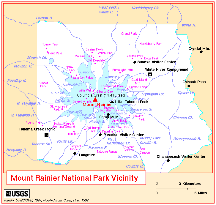
| Location Maps |

| Useful Links |
| For More Information |
 Mount Rainier Volcano Menu
Return to:
["Visit A Volcano" Menu] ...
[Mount Rainier Volcano Menu]

![[medium size]](https://webarchive.library.unt.edu/eot2008/20090116081415/http://vulcan.wr.usgs.gov/Imgs/Jpg/Rainier/Images/Rainier75_mount_rainier_from_paradise_1975_med.jpg)
![[large size]](https://webarchive.library.unt.edu/eot2008/20090116081415/http://vulcan.wr.usgs.gov/Imgs/Jpg/Rainier/Images/Rainier75_mount_rainier_from_paradise_1975.jpg)