

 Products
Wildlife photos from a motion-triggered camera used in wildlife research in Orange County between Los Angeles and San Diego managed to survive the fire intact, along with some astonishing photos.
Dr. Erin Boydston and Lisa Lyren, USGS researchers who have conducted carnivore research using this and other cameras, said the photos show some before and after the fire pictures – including one of a coyote apparently fleeing from the fire. Possibly the same coyote triggered the camera again one and a half days later.
The pictures were acquired using a “camera trap,” a camera wired with motion sensors to automatically take photos when the sensors detect movement in the camera’s field of view. Camera traps, said Lyren, are widely used in carnivore research because they help document the behavior and distribution of these more elusive, often-nocturnal animals.
This camera trap is on the former El Toro Marine Base, an area that burned last week in the Orange County Santiago Fire. This particular area was the southernmost extension of the fire, where it crossed over a toll road into this small peninsula of habitat surrounded on the other three sides by urban development, small agricultural fields and the main part of the former Marine Base.
Boydston, Lyren and other colleagues at the U.S. Geological Survey have been studying bobcats and coyotes in Orange County since 2002 in collaboration with Dr. Kevin Crooks at Colorado State University.
Extensive camera data and data from GPS-collared animals from before the fire provide an understanding of how carnivores were already using this complex landscape of open spaces, roads and urban areas.
“We hope that we are able to do follow-up research to help discern where the displaced carnivores go, as the options are slim between urban areas or unburned areas that already have bobcats and coyotes present who will not welcome newcomers to their territories,” Boydston said. “If so, we will have the opportunity to understand how fires interact with patterns of carnivore behavior and ecology and what the implications are for conservation of these species, especially in habitat surrounded by urban areas.”
USGS-CSU collaborative research across Orange County has been funded by the Orange County Great Park Corporation, The Irvine Company, The Nature Conservancy, Transportation Corridor Agencies, and USGS.
NOTE FOR EDITORS: Time stamps on the images are in Pacific Standard Time. For high-resolution, copyright-free images of the images of wildlife captured by the movement-triggered camera , click on the thumbnail images below. Please credit photos to the USGS.
For more information on USGS wildfire work, please see url: http://www.usgs.gov/hazards/wildfires
 |
A coyote walking in dry creek bed of streamside scrub vegetation dominated by the native plant, mule fat (Baccharis salidifolia), about 20 days before the fire. In their wildlife research, USGS scientists position camera traps along trails and dry creek beds, places that are likely to be travel routes for carnivores. From this particular location in Borrego Wash, the researchers have obtained 32 photos of bobcats and 7 of coyotes since March 16, 2007. Photo credit: USGS. |
 |
Movement triggers the camera, and moving vegetation can sometimes trigger a picture. At 09:45 a.m. PST on Oct. 21, 2007, the Santa Ana winds picked up and triggered a photo, followed by additional photos that morning of the windy conditions, including this one at 10:44 a.m. PST. Photo credit: USGS. |
 |
At 4:50 a.m. PST on Oct. 22, 2007, a coyote runs into the wash, presumably fleeing from the fires. Photo credit: USGS. |
 |
After the photo of the coyote on the run, the next photo on the camera shows high-intensity flames at 9:00 a.m. PST on Oct. 22, 2007. Photo credit: USGS. |
 |
At 09:01 a.m. PST, just one minute after the intense flames, the fire seems to have passed this particular point, leaving only the skeletons of the mule fat plant and other streamside shrubs that continue to burn. Photo credit: USGS. |
 |
The camera continued to take one photo per minute for 10 minutes after the fire, until this one at 09:10 a.m. PST on Oct. 22, 2007, showing smoke, burnt and smoldering vegetation and windy conditions. The remnants of some field research equipment are lying melted under a nearby tree. Photo credit: USGS. |
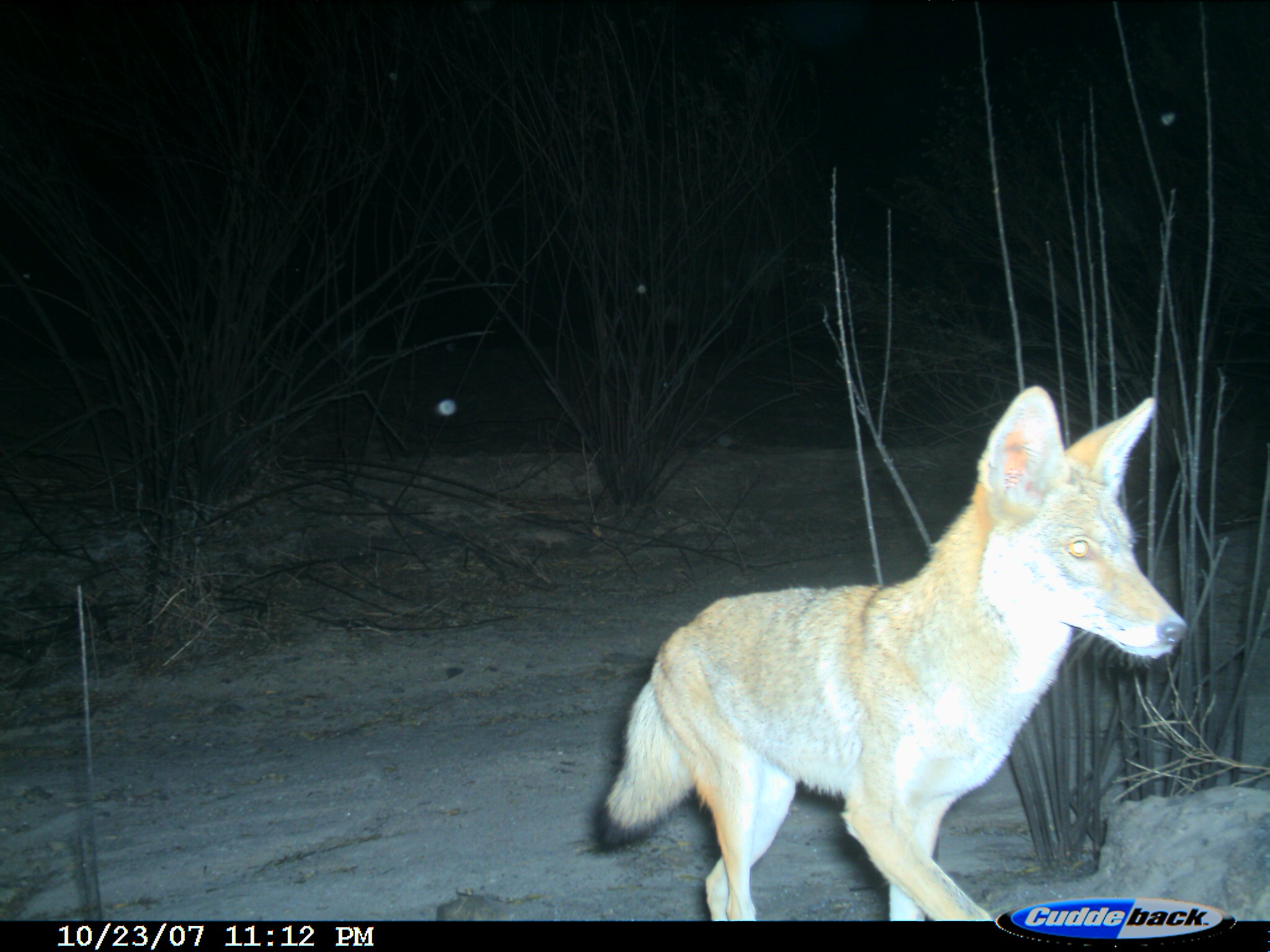 |
The next photo on the camera at 11:12 p.m. PST on Oct. 23, 2007, shows a coyote walking out of the wash at night, a day and a half after the fire, heading back in the direction from which the coyote was running on the early morning of Oct. 22, 2007. Photo credit: USGS |
