|
Deep Quakes in Washington and Oregon
Although several types of damaging earthquakes occur in Washington and Oregon,
deep earthquakes beneath Puget Sound, at depths from 30 km to 70 km, have historically done the most
damage. Although the other types of earthquakes can be much larger,
damaging deep earthquakes are more frequent, occurring every 30 years or so.
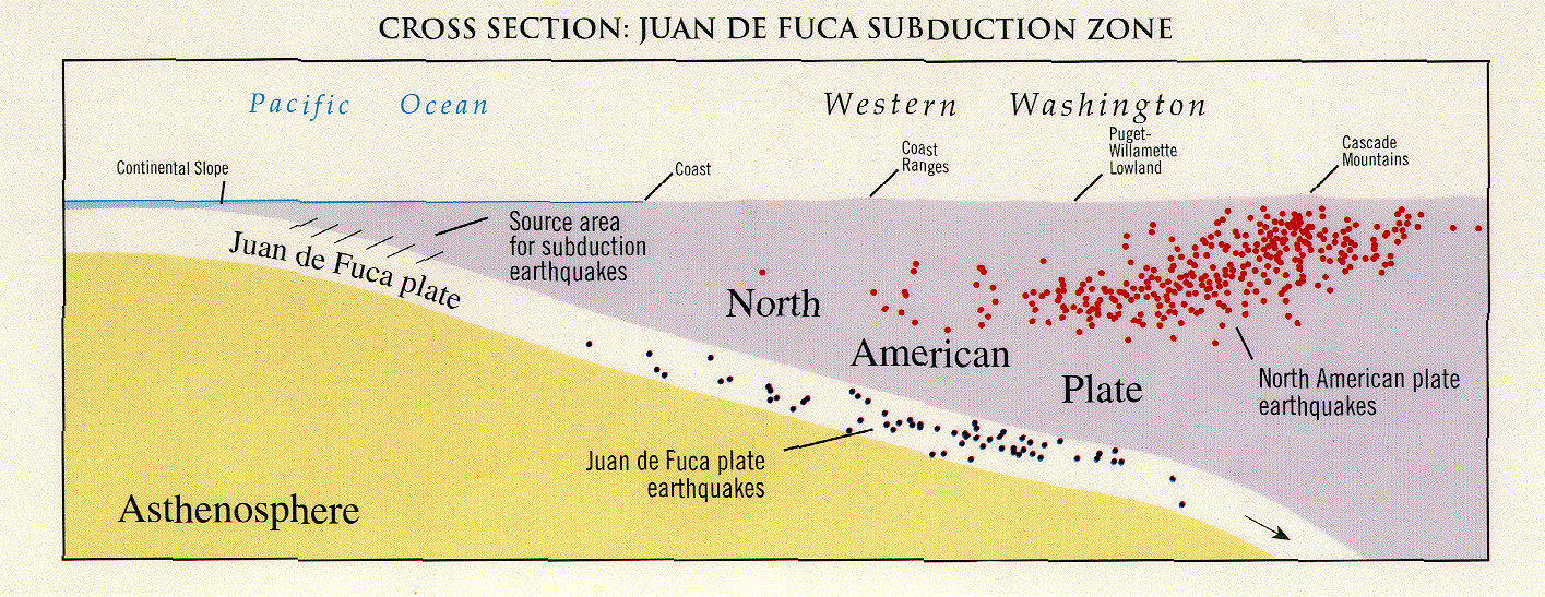
A schematic diagram shows the relative postions of the
Juan de Fuca and North American Plates. The pink squares show the positions of the 1965 and 1949 earthquakes in map view and cross-section. The 1949 earthquake caused over $100 million in damage, including damage to the Capitol Building in Olympia. The 1965 earthquake caused over $50 million in damage. As time goes on,
there has been growth, development and greater economic activity in
the Puget Sound area, increasing the likelihood of costly losses
from future earthquakes. Damage figures from the 2001 earthquake are still being compiled
Earthquakes losses from all types of faults can be decreased
through land-use planning, good building standards, retrofitting, securing
non-structural elements (gas water heaters, bookshelves, computers, etc.),
and advance planning for response and recovery.
Deep earthquakes, also called
"Benioff Zone earthquakes" reach magnitudes as high as 7.5. For example,
a magnitude 7.5 Benioff Zone quake beneath Oaxaca, Mexico occurred on Sept. 30, 1999.
Benioff Zone earthquakes usually have dip-slip, or normal faulting, and no large aftershocks. These earthquakes are caused by mineral changes as the plate goes to deeper depths and is exposed to increased temperature and pressure. The mineral changes cause the
plate to shrink and become more dense. Stresses build up which pull the plate
apart.
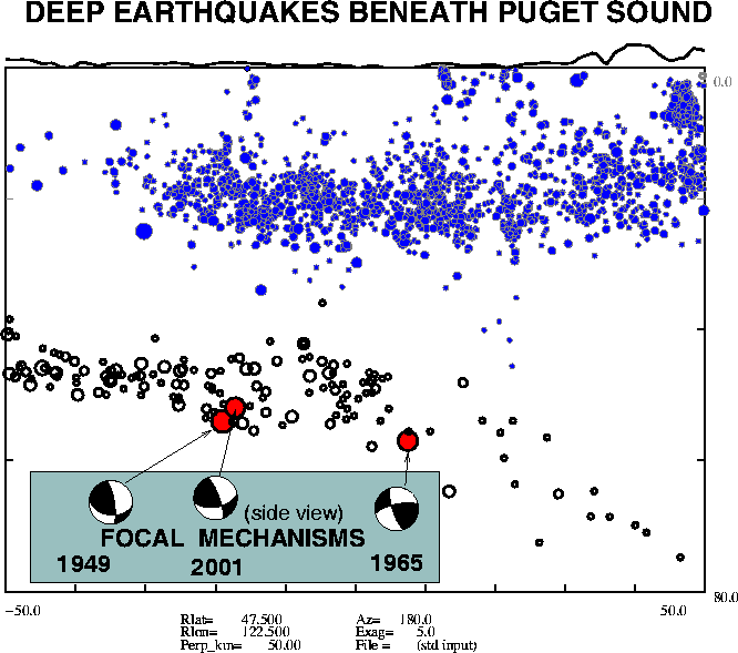
Damaging Benioff Zone Earthquakes in Washington
CAPTION
The pink squares on the schematic diagram show the positions of the 2001, 1965 and 1949 earthquakes in map view and cross-section, and the relative postions of the
Juan de Fuca (JDF) and North American Plates.
The depth of the subducting Juan de Fuca (JDF) Plate is known from several lines
of evidence. The map below shows the lines countouring the shape
of the subducting JDF plate at 30, 40, 50, and 60 km depth. The subducting plate is not a flat plane; there is an arch in the central Puget Sound.
Earthquakes within the JDF plate are shown
in different colors, according to their depths. Earthquake depths range from 30 km in the western part of the Olympic Peninsula to more than 70 km beneath the
Cascades. For certain points, marked by colored squakes, the orientation
and depth of the subducting plate are known from special "receiver studies"
of wave arrivals from distant worldwide earthquakes.
For each square, the strike (see the glossary) of the subducting plate is indicated by the long top of the T shape, and the dip (see the glossary) direction by the short leg of the T. The depth and dip are given below each point.

Cross-Section of Seismicity in the North America Continental Plate, and the subducting Juan de Fuca Plate
Click on figure to view enlarged version
Another Cross-Section, highlighting the 2001, 1965, and 1949 quakes in relation to seismicity in the North America Continental Plate and the subducting Juan de Fuca Plate
Click on figure to view enlarged version
REFERENCES
Cassidy, John Francis, 1991,
Teleseismic receiver function analysis of the crust and upper mantle of southwestern British Columbia, Ph. D. Thesis,
[Vancouver, B.C.] University of British Columbia
Crosson, R.S. and T. J. Owens, 1987, Slab Geometry of the Cascadia
Subduction Zone beneath Washington from earthquake hypocenters and
converted phases, Geophys. Res. Lett. V. 14, No. 8 pp. 824-827
Edlund, Kimberley Marie, 1991,
Geometric constraints for the Cascadia subduction zone beneath
Indian Island, Washington from teleseismic receiver function analysis,
M.S. Thesis, [Seattle, WA] University of Washington.
Goter, Susan K., Earthquakes in Washington and Oregon; 1872-1993, 1994,
Open-File Report - U. S. Geological Survey,
U. S. Geological Survey. Reston, VA, United States. Pages: 1, 1 sheet. 1994.
Lapp, David Benjamin, 1987
The subduction geometry beneath western Washington from deconvolved
teleseismic P-waveforms,
M.S. Thesis, [Seattle, WA] University of Washington.
Lapp, D.B., T.J. Owens, and R.S. Crosson, 1990
P-waveform analysis for local subduction geometry south of Puget Sound,
Washington,
Pure and Applied Geophysics. 133; 2, Pages 349-365.
Peacock, S. and K. Wang, 1999, Seismic Consequences of Warm Versus Cool Subduction Metamorphism, Science, 286: 937-939
|


