USGS CoreCast
USGS Podcasts Home > CoreCast Home Page
Can't see Flash? Install Flash Player.
|
57
|
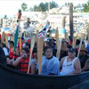
The USGS and the Coast Salish Tribal Nation have partnered during the annual Tribal Canoe Journey to study and help improve resources of the Salish Sea. This first episode in the Corecast Tribal Journey series examines the new partnership between the USGS and Coast Salish people. Play Video: (downloading may take some time due to file sizes)
Type: video/mp4
File Size: 19747460 bytes Duration: 7:36 Released: Fri, 1 Aug 2008 15:00:00 UTC |
Transcript:
|
[music background playing and fading out] Jennifer LaVista: Welcome, and thanks for tuning in to this episode of CoreCast. I'm Jennifer LaVista. |
|
| 01:00 | What I have been seeing for sure is the fish declining - the fisheries declining. I think, our fishermen, they're lucky to get 2 or 3 days out of the year for fishing Sakai and while I was fishing in Sakai just out of high school we're out there for like 2 weeks. Sometimes we got there 3 weeks, that's basically why I got out of the fisheries, because I saw that happening, and you know there's a lot of dead zones down at south Puget Sound there you know, you hear that on the news all the time. They're talking about how the oxygen level and especially in the Hood Canal has declined way down. And you always hear on the news about the water temperature rising and you know the fish, they don't like it when it's warm. Eric Grossman (Tribal Journey Science Advisor/USGS Geologist): We have several projects within the USGS that work on issues related to habitats and water quality. And one of them is the Coastal Habitats and Puget Sound project. That is a project that is integrating scientists from biology, geology, hydrology, chemistry, geography, to answer certain problems related to land use and its impact on near-shore habitat and environments. |
| 02:16 | As part of that project, we work here in the Skagit Delta and over the last 2 or 3 years, we've been working quite closely with Swinomish Tribe and the Skagit River System Cooperative who supports the Swinomish Tribe. [Preparing to leave] We had several conversations about other types of opportunities for conducting this science and it was mentioned there's an annual canoe journey and it donned on me that a great methodology would be fastening this water-quality probes behind multiple canoes during the summer journey and having the canoes, mapping out the water bodies across the Salish Sea. Eric Day: Eric Grossman was coming up here to actually-- in Skagit bay doing a lot of water test in Skagit bay. |
| 03:06 |
I don't know when he came up with the idea, but him and Deborah Lacana they've pulled me aside and asked me what I thought, you know, the other canoe skippers would think, if we did a water-quality test out on the water, we brought it out well we don't know if one or two guys want to do this but you know, like 7 or 8 people will come up and say "Yeah, we'll take a probe. Yeah we'll take a probe" and we only had 5 probes. When we first started, we were only taking maybe 1 or 2. And then pretty soon, when we had 20 people already, they say "Hey, let's do it,you know, we want to do it. " [Holding a water-quality probe] Eric Grossman: So this is a multi-parameter water-quality probe. This particular one is from YSI Environmental International. And it's multi-parameter in terms of being able to measure a number of water quality properties. |
| 04:00 |
We have a temperature sensor, a conductivity sensor, a pH sensor, depth, and these larger ones are optical turbidity, and optical dissolved oxygen. And this will be traveling behind the canoe, being towed by the canoe in the surface water, meaning the upper half meter of the water column, and measuring those water parameters every few seconds, but recording every 10 seconds. And along with this is a fancy handheld marine GPS that will be tagging those measurements every 10 seconds so we have a fixed position along the water. And these data are integrated in a small handheld computer here, again every 10 seconds. And what we will do is log the entire journey from take off point in the morning to ending point in the afternoon. |
| 05:06 | [installing the instruments in the canoe] And simply download the data in when it arrives the shore and that data file then is then e-mailed into our central server at Washington Water Science Center. And Ray Julich we'll be mapping them up, almost near real time, every afternoon, and displaying the results on Google Maps interface for the world to see. So these different parameters that will be measured will be mapped out this year behind canoe, along six or so different pathways. And essentially this year would be just a baseline mapping of conditions in late July 2008. But they might lead to important anomalies and important areas of water quality concern that we can return to and study in a little more detail. |
| 06:00 | Bob Doyle: (USGS Deputy Director) The Coast Salish Tribal Nation's invitation to us to join in this science project really is an honor for us to have an opportunity to be with them on this annual journey that they take. [Bob Doyle rowing in a canoe] And it's really given us an opportunity for them to share with us their traditions, their values, their culture. So it's a great opportunity for us. Eric Grossman: The hope is to integrate this traditional local knowledge of the Coast Salish people. They've canoed these waters, they fished these waters, they've lived off these waters for the last hundreds of years, thousands of years and they have an understanding of the different characteristics of the environment, where fish were plentiful, where eel grass was healthy, where there was turbidity, where there's wasn't, and we might be able to marry some of this science with their long standing knowledge to better understand the recent trends. [Canoeing on a river] Bob Doyle: I hope to see this partnership continue to strengthen and grow and to expand to a number of the other tribes in the area. I think again it's a great opportunity to marry our science with the traditional knowledge, and to help share with the nation about changes that are occurring here and the ecological system. |
| 07:11 |
[Canoeing on a river] [music background playing and ending] |
Read more information about the USGS and Coast Salish partnership.