USGS/CVO Logo, click to link to National USGS Website
USGS/Cascades Volcano Observatory, Vancouver, Washington

Mount St. Helens, Washington
May 18, 1980, Ash Fallout Distribution within the U.S.


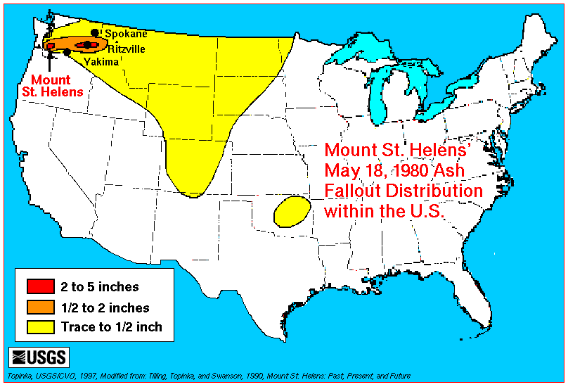
This generalized map shows the distribution of ash fallout from the May 18, 1980 eruption. -- Modified from: Tilling, Topinka, and Swanson, 1990, Eruptions of Mount St. Helens: Past, Present, and Future: USGS Special Interest Publication

Map, May 18, 1980 Ash Fallout Distribution


Return to:
[Mount St. Helens May 18, 1980 Menu] ...
[Mount St. Helens Tephra Menu] ...


CVO HomePage Volcanoes of the World Menu Mount St. Helens Menu Living With Volcanoes Menu Publications and Reports Menu Volcano Monitoring Menu Servers and Useful Sites Menu Volcano Hazards Menu Research and Projects Menu Educational Outreach Menu Hazards, Features, and Terminology Menu Maps and Graphics Menu CVO Photo Archives Menu Conversion Tables CVO Index - Search Our Site ButtonBar

URL for CVO HomePage is: <http://vulcan.wr.usgs.gov/home.html>
URL for this page is: <http://vulcan.wr.usgs.gov/Volcanoes/MSH/Maps/may18_ashmap.html">
If you have questions or comments please contact: <GS-CVO-WEB@usgs.gov>
02/10/08, Lyn Topinka