click on thumbnail for "user-friendly" medium-size image ...
medium-size images are around 100 K and best for web viewing ...
large-size images are 4-8 M, scanned images, no logo, 300 dpi, 8x10 to 9x12 size, and good for printing and publication ...
MSH80_eruption_mount_st_helens_05-18-80.jpg On May 18, 1980, at 8:32 a.m. Pacific Daylight Time, a magnitude 5.1 earthquake shook Mount St. Helens. The bulge and surrounding area slid away in a gigantic rockslide and debris avalanche, releasing pressure, and triggering a major pumice and ash eruption of the volcano. Thirteen-hundred feet (400 meters) of the peak collapsed or blew outwards. As a result, 24 square miles (62 square kilometers) of valley was filled by a debris avalanche, 250 square miles (650 square kilometers) of recreation, timber, and private lands were damaged by a lateral blast, and an estimated 200 million cubic yards (150 million cubic meters) of material was deposited directly by lahars (volcanic mudflows) into the river channels. Fifty-seven people were killed or are still missing.
USGS Photograph taken on May 18, 1980, by Austin Post.
[medium size] ...
[large size] ...
[TIF Format, 39.5 M]
MSH80_eruption_mount_st_helens_05-18-80_bw.jpg Eruption of Mount St. Helens.
USGS Photograph taken on May 18, 1980, by Austin Post.
[medium size] ...
[large size] ...
[TIF Format, 13.5 M]
MSH80_eruption_mount_st_helens_plume_05-18-80.jpg For more than nine hours a vigorous plume of ash erupted, eventually reaching 12 to 15 miles (20-25 kilometers) above sea level. The plume moved eastward at an average speed of 60 miles per hour (95 kilometers/hour), with ash reaching Idaho by noon. By early May 19, the devastating eruption was over. Shown here is a close-up view of the May 18 ash plume.
USGS Photograph taken on May 18, 1980, by Donald A. Swanson.
[medium size] ...
[large size] ...
[TIF Format, 18 M] ...
MSH80_may_18_eruption_column_05-18-80_bw.jpg The eruption of May 18, 1980 sent volcanic ash, steam, water, and debris to a height of 60,000 feet. The mountain lost 1,300 feet of altitude and about 2/3 of a cubic mile of material stream downward from the center of the plume and the formation and movement of pyroclastic flows down the left flank of the volcano.
USGS Photograph taken on May 18, 1980, by Austin Post.
[medium size] ...
[large size]
MSH80_msh_eruption_05-18-80_Krimmel_80S3-141_bw.jpg May 18, 1980 eruption of Mount St. Helens. Original negative is 9x9 black/white aerial.
USGS Photograph taken on May 18, 1980, by Robert Krimmel.
[medium size] ...
[large size]
MSH80_eruption_plume_with_adams_05-18-80_bw.jpg May 18, 1980 eruption of Mount St. Helens, Mount Adams is in the background (right).
Original negative is 9x9 black/white aerial. Image scanned from print.
USGS Photograph taken on May 18, 1980, by Robert Krimmel.
[medium size] ...
[large size] ...
MSH80_eruption_mount_st_helens_distance_05-18-80.jpg May 18, 1980 eruption of Mount St. Helens.
USGS Photograph taken on May 18, 1980, by Joseph Rosenbaum.
[medium size] ...
[large size] ...
[TIF Format, 38 M]
May 19, 1980
MSH80_st_helens_plume_from_NW_05-19-80.jpg Day after the May 18, 1980 eruption of Mount St. Helens.
USGS Photograph taken on May 19, 1980, by Peter Lipman.
[medium size] ...
[large size] ...
[TIF Format, 24 M]
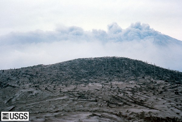
MSH80_blowdown_with_st_helens_05-19-80.jpg Day after the May 18, 1980 eruption of Mount St. Helens. View of denuded slope and blowdown timber, with a still steaming Mount St. Helens in the background.
USGS Photograph taken on May 19, 1980, by Peter Lipman.
[medium size] ...
[large size] ...
[TIF Format, 24 M]
 Use of CVO Material and Copyright Information