|
|
|
|
|
| Flood Insurance Rate Maps |
|
|
|
|
| Flood Preparation & Response |
|
|
| Tips to Minimize Flood Damage |
|
|
|
|
|
| Weather Forecasts & Climate Links |
|
|
|
|
| Meeting Agendas, Summaries & Presentations |
|
|
|
|
|
|
|
| Chatfield Downstream Channel Improvement Project |
|
| Chatfield Reservoir Reallocation Project |
|
|
|
|
|
|
|
|
|
| Weather Modification Grants |
|
|
|
|
|
| Floodplain & Storm Criteria Manual |
|
|
| Frequently Asked Questions |
|
|
|
|
|
|
|
|
|
|
|
|
|
Search the Water Resource Information Center via WebLink
Date
Document Type
Click Search to see archived documents. Results can be limited by entering dates and/or a document type.

|
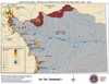
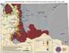
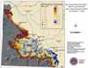
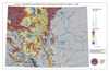
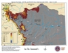
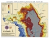
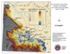
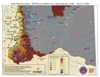
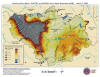
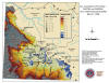
SNODAS Snowpack Maps
|
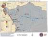
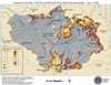
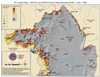
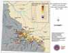
The maps below show the snow-water equivalent in the mountain snowpack. Data from these maps is analyzed by CWCB staff to determine the risk of snowmelt flooding for individual river basins, and statewide.
Maps may be posted several times a month as SNODAS data becomes available. Additional maps will be posted if the need arises, and data is available.
Maps Prior to 2008: Use the Search available here by limiting to a date range and the document type Drawing/Map. To limit further, once inside of WebLink, type SNODAS* in the Document Title field, choose Drawing/Map from the Document Type dropdown and click Search.
Click on the date of interest to be taken to a pdf containing all of that day's maps.
June 1, 2008
|
 |
 |
|
 |
|
Arkansas Basin |
Colorado/North Platte Basins |
Gunnison Basin |
Rio Grande Basin |
|
 |
 |

|

|
|
San Juan/Dolores Basins |
South Platte Basin |
Yampa/White Basins |
Statewide |
May 13, 2008
|
|

|
|
|
|
Statewide |
|
May 1, 2008
|
 |
 |

|
 |
|
Arkansas Basin |
Colorado/North Platte Basins |
Gunnison Basin |
Rio Grande Basin |
|
 |
 |

|

|
|
San Juan/Dolores Basins |
South Platte Basin |
Yampa/White Basins |
Statewide |
April 13, 2008
|
 |

|

|
 |
|
Arkansas Basin |
Colorado/North Platte Basins |
Gunnison Basin |
Rio Grande Basin |
|
 |

|

|

|
|
San Juan/Dolores Basins |
South Platte Basin |
Yampa/White Basins |
Statewide |
March 31, 2008
|

|
 |

|

|
|
Arkansas Basin |
Colorado/North Platte Basins |
Gunnison Basin |
Rio Grande Basin |
|
|
 |
|
|
San Juan/Dolores Basins |
South Platte Basin |
Statewide |
March 15, 2008
|
|

|

|
|
|
Arkansas Basin |
Colorado/North Platte Basins |
Gunnison Basin |
Rio Grande Basin |
|
|
|

|
|
San Juan/Dolores Basins |
South Platte Basin |
Statewide |
March 1, 2008
|

|

|
|

|
|
Arkansas Basin |
Colorado/North Platte Basins |
Gunnison Basin |
Rio Grande Basin |
|
|

|

|
|
San Juan/Dolores Basins |
South Platte Basin |
Statewide |
|
|
|
|
|