U.S. Geological Survey
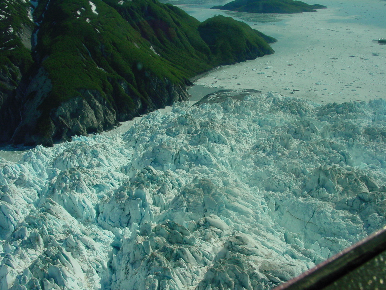
 June 13, 2002, west-view from above Russell Fiord, looking toward Yakutat Bay and Turner Glacier. The advancing terminus of Hubbard Glacier is in the foreground. The point of closure is not visible, blocked from view by Gilbert Point. USGS Photograph by Bruce F. Molnia (6/13/02-24) |
 June 13, 2002, south-view from above the advancing terminus of Hubbard Glacier, of the mouth of Russell Fiord, showing the glacier margin and the push moraine that is blocked the entrance of the fiord. The push moraine is composed of sediment bulldozed from the floor of Russell Fiord by the advancing ice. Some of this sediment can be seen in contact with the bedrock on the south wall of the fiord. Water exiting Russell Fiord has cut a channel into the top of the moraine. USGS Photograph by Bruce F. Molnia (6/13/02-29) |
 June 13, 2002, southwest-view from above the advancing terminus of Hubbard Glacier, of the mouth of Russell Fiord, showing the glacier margin and the push moraine that blocked the entrance of the fiord. The push moraine is composed of sediment bulldozed from the floor of Russell Fiord by the advancing ice. Some of this sediment can be seen in contact with the bedrock on the south wall of the fiord. Water exiting Russell Fiord has cut a channel into the top of the moraine. USGS Photograph by Bruce F. Molnia (6/13/02-30) |
 June 13, 2002, southwest-view from above the advancing terminus of Hubbard Glacier of the channel cut into the top of the push moraine that blocked the mouth of Russell Fiord. The push moraine is composed of sediment bulldozed from the floor of Russell Fiord by the advancing ice. Some of this sediment can be seen in contact with the bedrock on the south wall of the fiord. This photograph was made at high tide. USGS Photograph by Bruce F. Molnia (6/13/02-31) |
 June 13, 2002, southeast-view from above the mouth of Russell Fiord showing the advancing terminus of Hubbard Glacier and the channel cut into the top of the push moraine that blocked the mouth of Russell Fiord. A push moraine is sediment bulldozed from the floor of Russell Fiord by the advancing ice. Some of this sediment can be seen in contact with the bedrock on the south wall of the fiord. This photograph was made at high tide. USGS Photograph by Bruce F. Molnia (6/13/02-33) |
 June 13, 2002, southwest-view from above Russell Fiord, looking toward the mouth of Yakutat Bay. The advancing terminus of Hubbard Glacier is in the foreground. The push moraine that blocked the mouth of the fiord is located to the right of center. A push moraine is sediment bulldozed from the floor of Russell Fiord by the advancing ice. USGS Photograph by Bruce F. Molnia (6/13/02-40) |
 June 13, 2002, southwest-view from above Russell Fiord, looking toward the mouth of Yakutat Bay. The advancing terminus of Hubbard Glacier is in the foreground. The push moraine that blocked the mouth of the fiord is located to the right of center. A push moraine is sediment bulldozed from the floor of Russell Fiord by the advancing ice. USGS Photograph by Bruce F. Molnia (6/13/02-41) |
 June 13, 2002, southwest-view from above the advancing terminus of Hubbard Glacier looking toward the push moraine that is blocking the mouth of Russell Fiord. A push moraine is sediment bulldozed from the floor of Russell Fiord by the advancing ice. Yakutat Bay is in the distance. The advancing terminus of the glacier is moving down Yakutat Bay and also into Russell Fiord. This photograph was made at high tide. USGS Photograph by Bruce F. Molnia (6/13/02-46) |
 June 13, 2002, southwest-close-up-view from above the advancing terminus of Hubbard Glacier of the channel cut into the top of the push moraine that blocked the mouth of Russell Fiord. A push moraine is sediment bulldozed from the floor of Russell Fiord by the advancing ice. Some of this sediment can be seen in contact with the bedrock on the south wall of the fiord. This photograph was made at high tide. USGS Photograph by Bruce F. Molnia (6/13/02-49) |
 June 13, 2002, south-close-up-view from above the advancing terminus of Hubbard Glacier of the channel cut into the top of the push moraine that blocked the mouth of Russell Fiord. A push moraine is sediment bulldozed from the floor of Russell Fiord by the advancing ice. Some of this sediment can be seen in contact with the bedrock on the south wall of the fiord. This photograph was made at high tide. USGS Photograph by Bruce F. Molnia (6/13/02-51) |
 June 13, 2002, east-up-view from above the center of the advancing terminus of Hubbard Glacier of the push moraine that blocked the mouth of Russell Fiord. A push moraine is sediment bulldozed from the floor of Russell Fiord by the advancing ice. A part of the glacier that is advancing into Russell Fiord can be seen at the left edge of the photograph. USGS Photograph by Bruce F. Molnia (6/13/02-58) |
 June 13, 2002, northeast-up-view from south of the advancing terminus of Hubbard Glacier, of the push moraine that blocked the mouth of Russell Fiord. A push moraine is sediment bulldozed from the floor of Russell Fiord by the advancing ice. Part of the glacier that is advancing into Russell Fiord can be seen in the center of the photograph. USGS Photograph by Bruce F. Molnia (6/13/02-59) |
 June 13, 2002, northeast-up-view from south of the advancing terminus of Hubbard Glacier, of the push moraine that blocked the mouth of Russell Fiord. A push moraine is sediment bulldozed from the floor of Russell Fiord by the advancing ice. Part of the glacier that is advancing into Russell Fiord can be seen in the center of the photograph. USGS Photograph by Bruce F. Molnia (6/13/02-60) |

![]() U.S. Department of the Interior |
U.S. Geological Survey
U.S. Department of the Interior |
U.S. Geological Survey
URL: http://www.usgs.gov/features/glaciers.html
Page Contact Information:
Ask USGS
Page Last Modified: 22-Aug-2002@10:56
