|
|
| Overview |
|---|
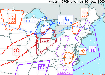
The new Graphical-AIRMET product, known as the "G-AIRMET," is a decision-making tool based on weather "snapshots" displayed at short time intervals. The G-AIRMET identifies hazardous weather in space and time more precisely than text products, enabling pilots to maintain high safety margins while flying more efficient routes.
At NOAA, our goal is to maximize aviation safety and air space efficiency by providing the most accurate and timely weather information possible to enhance both pre-flight and in-flight decision making. For decades, NOAA has issued text-based AIRMETs (Airmen's Meteorological Information) that have provided broad-scale descriptions of hazardous weather. Often referred to as a time "smear", the text-based AIRMET requires meteorologists to describe hazardous weather over large geographical areas for six-hour periods. G-AIRMET provides more precise, and informative weather hazard depictions than the text only AIRMET.
Aviation weather users have found that pictures are worth a thousand contractions. G-AIRMETs provide a better path from the aviation meteorologist to the weather user, by providing precise, interactive and easy to understand graphical displays. Meteorologists can put their energy into creating and updating G-AIRMET weather graphics, while the traditional text AIRMET is generated from, and completely consistent with G-AIRMET information.
|
| |
| Details |
|---|
Graphical AIRMETs (G-AIRMET): are graphical forecasts of en-route weather hazards valid at discrete times no more than 3 hours apart for a period of up to 12 hours into the future (00, 03, 06, 09 and 12 hours). 00 hour represents the initial conditions, and the subsequent 3-hourly graphics depict the area affected by the particular hazard at that valid time. G-AIRMET depicts the following en-route aviation weather hazards:
- Instrument flight Rule conditions (IFR)
- Mountain Obscuration
- Icing
- Freezing Level
- Turbulence
- Low Level Wind Shear (LLWS)
- Strong Surface Winds
|
| G-AIRMETs are issued every 6 hours and updated/amended as necessary, coincident with the text AIRMET products. G-AIRMETs provide additional weather information and higher forecast resolution than text AIRMET products alone. Since G-AIRMETs and text AIRMETs are created from the same forecast "production" process, there exists perfect consistency between the two. Using the two together will provide clarity of the area impacted by the weather hazard, and improve situational awareness and decision making. |
| |
| G-AIRMET Availability and Format: G-AIRMETs can be viewed using the G-AIRMET display tools at: http://www.aviationweather.gov/products/gairmet/. A user tutorial (FLASH) is also available. |
| |
| G-AIRMETs are also provided in ICAO recommended “Binary Universal Form for the Representation of Meteorological Data” (BUFR) format. This is suitable for the integration into service provider and user systems. This format allows service providers or end users to customize G-AIRMET displays to their specific applications and unique systems. For each G-AIRMET valid time, the binary message will contain the following: |
- En-route weather phenomena (as appropriate)
- Valid time
- Type of message (Normal, Correction, Amendment, and Corrected Amendment)
- Location of each of the phenomena using geographical coordinates to delineate the affected areas.
|
| Click here to learn more about using BUFR files. |
| |
| WMO Headers (BUFR): |
| AIRMET | Aviation Hazard | WMO HEADER |
|---|
| SIERRA | IFR Ceiling | JUGE86 KKCI |
| IFR Visibility |
| Mountain Obscuration |
| TANGO | Turbulence | JUHE00 KKCI |
| Strong Surface Wind |
| Low Level Wind Shear Potential |
| ZULU | Icing | JUIE00 KKCI |
| Lowest Freezing Levels |
| Multiple Freezing Levels |
|
| |
| Navigation |
|---|
| 1) Select parameter by selecting appropriate button. Note that the button color will change to the color of the associated graphic |
 |
To deselect ... click on button again ... or select the  button button |
| 2) Select Valid time by clicking on a "valid time" or moving the button on the slider bar. |
 |
| or |
Click  to start looping and to start looping and  to stop looping. to stop looping. |
| The will reset the page. |
|
| |
| Legends: |
|---|
|
|
| |
| Background Information |
|---|
AIRMETs (Airmen’s Meteorological Information) are regularly scheduled text messages containing a 6 hour forecast with a 6 to 12 hour outlook period. AIRMETs are issued every 6 hours, where there is a 50% probability that any of the following en-route weather phenomena will cover an area of 3000 square miles or greater:
- Instrument flight Rule conditions (IFR): Areas of cloud ceilings with bases less than 1000 feet above ground level (AGL) and/or areas of surface visibilities below 3 statute miles, including the weather causing the visibility restriction. The cause of the visibility restriction includes only PCPN, FU, HZ, BR, FG, and BLSN.
- Mountain Obscuration: Areas of widespread mountain obscuration where Visual Meteorological Conditions (VMC) cannot be maintained, including the weather causing the obscuration. The weather causing the obscuration includes only CLDS, PCPN, FU, HZ, BR, and FG.
- Icing: Areas of moderate airframe icing, other than convectively induced, including the areal extent.
- Freezing Level information is included after AIRMETs for moderate icing or statements indicating that no significant icing is expected. Freezing level is defined as the lowest freezing level above the ground or at the SFC as appropriate. Freezing levels are delineated using high altitude VOR locations describing the location of the lowest freezing level above the ground or SFC as appropriate. Freezing levels above the ground are delineated at 4000 feet intervals above mean sea level (AMSL). Multiple freezing levels above the ground are delineated using "BOUNDED BY" followed by high altitude VOR locations. The range of freezing levels across the forecast area is also included.
- Turbulence: Areas of moderate turbulence, other than convectively induced, including the vertical extent.
- Low Level Wind Shear (LLWS): LLWS is defined as wind shear below 2000 feet AGL, other than convectively induced, exceeding 10 knots per 100 feet (vector difference between two points in space). LLWS potential information is included after AIRMETs for moderate turbulence and/or sustained surface winds greater than 30 knots or statements indicating no significant turbulence is expected. LLWS Potential information includes the list of affected states, and the phrase "BOUNDED BY" followed by high altitude VOR locations to delineate the area affected.
- Strong Surface Winds: Areas of sustained surface winds greater than 30 knots. The direction and speed of winds are not be depicted; only the area where sustained surface winds greater than 30 knots will occur.
|
| AIRMETs are prepared four times daily: 0300, 0900, 1500, and 2100 Universal Coordinated Time (UTC). The following information is included in the text AIRMET, as appropriate, and in the order indicated: |
- “AIRMET [NAME]” followed by a list of affected states or Great Lakes using two-letter abbreviations and/or coastal waters.
- Location of the phenomenon using a series of high altitude VORs to delineate the affected area.
- En-route weather phenomena which may affect the safety of aircraft operations as described above.
- Beginning and/or ending times of phenomena if different than the AIRMET bulletin times. The practice of including trend remarks is discontinued with the implementation of the G-AIRMET.
- Information describing when the weather the phenomena will end during the 6 hour valid time or during the 6 to 12 hour outlook period or continue through the outlook period.
- In the AIRMET 6 to 12 hour outlook, the affected area is described using “BOUNDED BY” followed by a series of high altitude VORs.
- SIGMET (Significant Meteorological Information) references are included in AIRMETS using the format “SEE SIGMET [NAME]” series.
|
|
Examples of AIRMETs (WORD)
|
| |
| FAQs |
|---|
| What is the difference between the 3-hourly G-AIRMET graphics and the “AIRMET” graphics I see? |
| A graphical representation of an AIRMET (as you might see on the ADDS SIGMET/AIRMET webpage http://adds.aviationweather.gov/airmets/ ) is a 6 hour "time-smeared" area of the valid AIRMET. G-AIRMET graphics are created and valid at 3 hour increments. During the production of AIRMETs, the 00, 03, and 06hr G-AIRMET polygons are added, or "smeared" together, producing the 6 hour AIRMET. You can find more information at G-AIRMET Presentation (July 2008) (PPT) |
| |
| Why is the G-AIRMET valid at 6 hours smaller than the 6-hour AIRMET? |
| As described in the previous question, the G-AIRMET valid at 6 hours is an areal depiction of that weather hazard as it is expected to exist at that moment (i.e. 6 hours from issuance). The 6-hour AIRMET, (valid for the 00-06 hour time period) is a depiction of the entire area that weather hazard will affect over a 6 hour period. |
| |
| Why do we have both G-AIRMETs and the old text AIRMETs? |
| Eventually, G-AIRMETs will replace AIRMET text products. While the G-AIRMET is able to better depict the weather hazard and its position over time, it can not be “read” over radio broadcasts and by briefers. Because of this, a requirement will continue to exist for a text version of en-route aviation weather hazards. The BUFR file-format of the G-AIRMET contains both graphic and “attribute” information, from which text can be derived, or “formatted”. Until this text portion of G-AIRMET can be tested and proved to meet safety of flight standards, both G-AIRMETs and legacy text AIRMETs will be produced. Remember, currently the legacy text AIRMET and G-AIRMET are both created by the AWC from the same production process, so there will always be consistency between them. |
| |
|
|
|