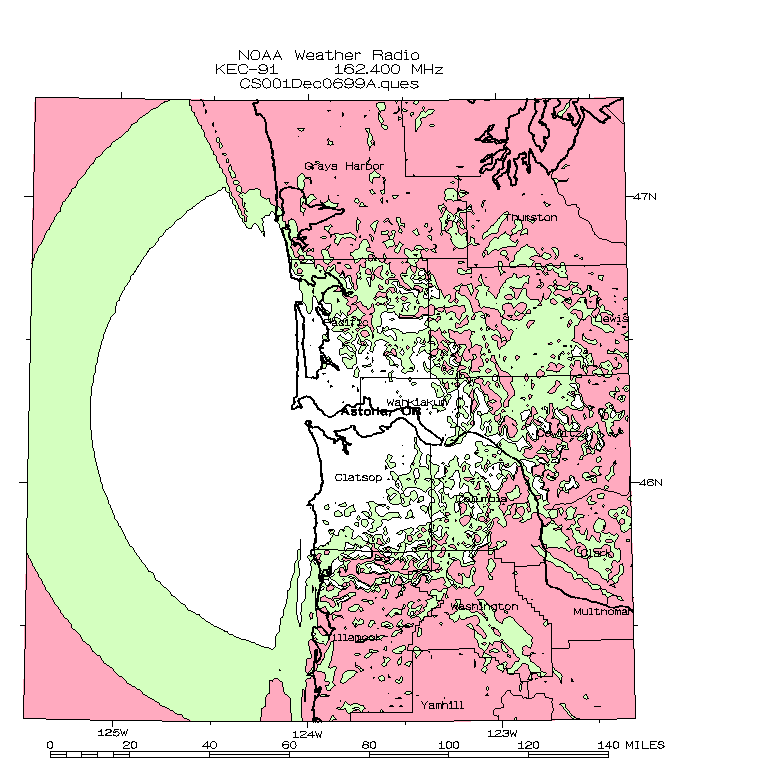
Astoria
162.400 MHz |
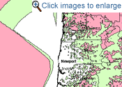
Newport
162.550 MHz |
Florence
162.500 MHz |

listening area map |
listening area map |

listening area map
|
Warnings for Counties:
Clatsop [ 041007 ]
Pacific [ 053049 ]
Wahkiakum [ 053069 ]
Tillamook [ 041057 ]
Grays River [ 053027 ]
W. Columbia [ 041009 ]
|
Warnings for Counties:
W. Lane [ 041039 ]
Lincoln [ 041041 ]
|
Warnings for Counties:
Lincoln [ 041041 ]
W. Lane [ 041039 ]
|
Repeaters:
Neahakanie Mtn: 162.425
Cape Meares: 162.475
Mt Hebo: 162.525
Includes a Mariner's Hour, which gives 2 hours (pre-dawn and evening) of continuous coastal marine weather. Rest of program focuses on coastal weather. |
Includes a Mariner's Hour, which gives 2 hours (pre-dawn and evening) of continuous coastal marine weather. Rest of program focuses on coastal weather. |
This will be a repeater of the Newport transmitter. Includes a Mariner's Hour, which gives 2 hours (pre-dawn and evening) of continuous coastal marine weather. Rest of program focuses on coastal weather. |
| |
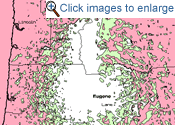
Eugene
162.400 MHz |
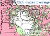
Portland
162.550 MHz |
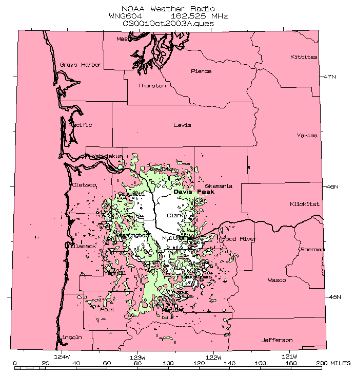
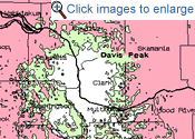
Woodland
162.525 MHz |
listening area map |
listening area map |
listening area map |
Warnings for Counties:
Lane [ 041039 ]
Benton [ 041003 ]
|
Warnings for Counties:
Multnomah [ 041051 ]
Washington [ 041067 ]
Clackamas [ 041005 ]
Yamhill [ 041071 ]
Hood River [ 041027 ]
Clark [ 053011 ]
Cowlitz [ 053015 ]
Columbia [ 041009 ]
|
Warnings for Counties:
Cowlitz [ 053015 ]
Columbia [ 041009 ]
Multnomah [ 041051 ]
Skamania [ 053059 ]
Lewis [ 053041 ]
Clark [ 053011 ]
Lewis River Basin
|
|
Weather focuses on South Willamette Valley, and the surrounding area, including the central Cascades of Lane County and the Central Coast Range. |
Weather focuses on North Willamette Valley, and the surrounding area, including the Cascades, Columbia Gorge, and Clark County in southwest Washington.
|
Weather focuses on Lower Columbia River Valley, and the surrounding area, including the Kelso, Woodland, Mt St Helens and the Cowlitz River Valley.
|
| |
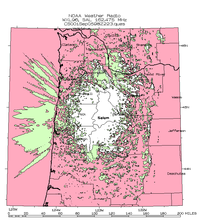
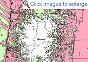
Salem
162.475 MHz |
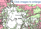
The Dalles
162.400 MHz |
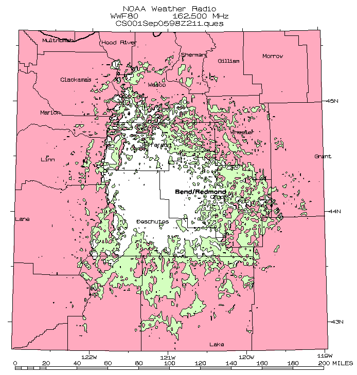
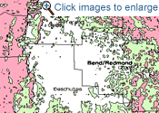
Bend/Redmond
162.500 MHz |
listening area map |
listening area map |
listening area map |
Warnings for Counties:
Linn [ 041043 ]
Marion [ 041047 ]
Polk [ 041053 ]
|
Warnings for Counties:
Wasco [ 041065 ]
Klickitat [ 053039 ]
|
Warnings for Counties:
Jefferson [ 041031 ]
Crook [ 041013 ]
Deschutes [ 041017 ]
|
|
Weather focuses on Mid-Willamette Valley, and the surrounding area, including the north Oregon Cascades and the north Coast Range. |
Weather focuses on East Columbia River Gorge, the north Oregon Cascades, and north central Oregon, as well as south central Washington. |
Weather focuses on central Oregon, including the Ochocos, central Cascades, and the high desert to the south of Bend. |