Available maps are listed below.
Alaska Shaded Relief (1969) -- Includes text on landforms,
geology, and other features of the United States. Stock #: 100656
Annual Sunshine, Evaporation, and Solar Radiation (1969)
-- Three maps of mean annual sunshine, annual pan evaporation, and May-October
evaporation. Five maps of annual solar radiation and mean solar radiation
for January, April, July, and October. SPA #: 100702
Classes of Land-Surface Form (1964) --
Land-surface forms of the conterminous United States, with an inset
of Hawaii. Stock #: 100661
Coastal Erosion and Accretion (1985) -- Indicates
annual shoreline change by bands of color adjacent to the coast .Text
and illustrations on the reverse side. Stock #: 101481
Coastal Hazards (1985) -- Illustrates eight coastal
and onshore hazard factors and the resulting overall hazard assessment
by bands of color adjacent to the coast. Text and illustrations on the
reverse side. Stock #: 101485
Congressional Districts for the 100th Congress (1987)
-- Congressional District numbers and boundaries for members of the
House of Representatives, shown with county boundaries. Stock #: 100641
Counties (1987) -- Names and boundaries of counties
and county equivalents shown with State names and boundaries. Stock
#: 101463
Early Indian Tribes, Culture Areas, and Linguistic Stocks (1967)
-- Distribution of early Indian tribes, with brief text on the reverse
side. Stock #: 101013
Engineering Aspects of Karst (1984) -- Distribution
of karst features and other features similar to karst. Text on the reverse
side. Stock #: 101408
Federal Lands (1968) -- Principal U.S. lands administered
or held in trust by Federal agencies as of January 1, 1968. Areas less
than 25,000 acres are generally not included. SPA #: 100854
Geology
(1966) -- Distribution of sedimentary, volcanic, and intrusive
rock types. Stock #: 100666
Highways (1987) -- The complete interstate system
with route markers and other selected major highways. Stock #: 101467
Land-Surface Form (1968) --A map of land-surface forms
of Alaska, with text on the classes of United States land-surface forms
and map showing physical subdivisions of the United States. Stock #: 100660
Major Forest Types (1987) -- Distribution of forest
types and nonforest lands in the conterminous United States, with insets
of Alaska and Hawaii. Stock #: 100615
Monthly Average Temperature (1965) -- One map showing
yearly mean daily high, mean, and low temperature for selected locations.
Twelve maps showing mean temperature by month. Stock #: 100791
Monthly Maximum Temperature (1965) --
One map showing yearly mean, mean daily high, and record daily high
temperature for selected locations. Twelve maps showing mean maximum
temperature by month. Stock #: 101413
Monthly Minimum Temperature (1965) -- One map showing
yearly mean, mean daily low, and record daily low temperature for selected
locations. Twelve maps showing mean minimum temperature by month. Stock
#: 100792
Monthly
Sunshine (1965) -- One map of theoretical maximum and mean
actual hours of yearly sunshine for selected locations. Twelve maps
of mean actual hours of sunshine by month. Stock #: 100673
National Wild and Scenic Rivers System (2000) -- Shows
designated wild and scenic rivers. An information table and photographs
are on the reverse side. Maps on both sides are at 1:5,000,000 scale.
Sheet size is 42 by 28 inches. Stock #: 101500
National Wilderness Preservation System (1987) --
Location of congressionally designated wilderness areas with administering
agencies indicated. All maps are at 1:5,000,000 scale. Sheet size is
42 by 28 inches. Stock #: 101414
Networks of Ecological Research Areas (1983) -- Location
of research areas designated by public and private agencies as secure
sites for basic and applied studies of natural processes. Classification
and description of sites on the reverse side. Stock #: 100848
Physiography and Physiographic Divisions (1968) --
Four maps of the conterminous United States showing physiographic regions
and provinces, physical divisions, and a physiographic diagram; and
one map with insets of Alaska and Hawaii showing topographic relief.
Stock #: 100657
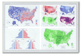
Population (1970) -- Four maps showing population
trends 1940-70, population density 1970, percent change in population
1960-70, and percent urban 1970. Stock #: 100795
Population
Distribution, Urban and Rural (1960) -- Cities of more
than 50,000 are shown by proportional circles, smaller cities and rural
areas are shown by dots. Stock #: 100639
Population Distribution, Urban and Rural (1970) --
Cities of more than 50,000 are shown by proportional circles, smaller
cities; and rural areas are shown by dots. Stock #: 100701
Potential Natural Vegetation (1985) -- Distribution
of eastern and western forest and western shrub and grassland types.
Text on the reverse side. Stock #: 100672
Presidential Election of 1988 (1989) -- Results of
the 1988 election by county, plus United States totals for popular and
electoral votes. Stock #: 101486
Presidential Elections (1789-1968 and 1972-84) --
Results of the 1789-1968 elections by State, and of the 1972-84 elections
by county, plus United States totals. Stock #: 101464
Principal Federal Lands Where Exploration and Development of
Mineral Resources are Restricted (1981) -- Areas of 5,000 acres
or more where mineral development is formally prohibited, or severely,
moderately, or slightly restricted. Text and maps of Alaska and
Hawaii on the reverse side. Stock #: 100616
Soils (1985) -- Principal kinds of soils (orders, suborders,
and great groups), with expanded definitions of classification on the
reverse side. Stock #: 100669
Surface Water (1965) -- Four maps of the
conterminous United States showing normal monthly runoff, maximum and
minimum annual runoff, and coefficient of variation, with text. Stock
#: 100793
Surface Water (1988) -- Five maps and a series of
graphs illustrating annual and monthly runoff, runoff of large rivers,
and surface water availability. Supplement to Surface Water (1965).
Stock #: 101499
Surficial Geology (1979) -- Distribution of transported,
untransported, and miscellaneous deposits for the conterminous United
States, with text on the reverse side. Stock #: 100832
Tectonic Features (1967) -- Tectonic features of
the conterminous United States, with an inset of Hawaii. Stock #: 100664
Tectonic Features (1968) -- A map of Alaska
map with text on U.S. tectonic maps and features. Stock #: 100664
Territorial Growth (1986) -- Thirteen maps showing
the territory of the United States for various years between 1775 and
1920. One map showing the United States and its outlying areas as of
March 1, 1986. Stock #: 100794
U.S. Satellite View (1990) -- A mosaic of 16 Advanced
Very High Resolution Radiometer (AVHRR) images taken from 1984 to 1986
and covering the conterminous United States. A duplicate mosaic with
explanatory captions is on the reverse side. Stock #: 101495
United
States Shaded Relief (1969) -- Illustrates the landforms
of the conterminous United States, with insets of Alaska and Hawaii.
Stock #: 100655