Tidal predictions 
South Atlantic
| Ascension | |
| 2007 | 2008 |
| 2009 | 2010 |
| St. Helena | |
| 2007 | 2008 |
| 2009 | 2010 |
| Tristan da Cunha | |
| 2007 | 2008 |
| 2009 | 2010 |
| Falkland Islands (Port Stanley) | |
| 2007 | 2008 |
| 2009 | 2010 |
| Signy (South Orkneys) | |
| 2007 | 2008 |
| 2009 | 2010 |
| Rothera | |
| 2007 | 2008 |
| 2009 | 2010 |
| Faraday/Vernadsky | |
| 2007 | 2008 |
| 2009 | 2010 |
British Overseas Territories
| Anguila (Road Bay) | |
| 2007 | 2008 |
| 2009 | 2010 |
| Bermuda (St Georges Island) | |
| 2007 | 2008 |
| 2009 | 2010 |
| South Caicos (Cockburn Harbour) | |
| 2007 | 2008 |
| 2009 | 2010 |
| Cayman Islands (George Town) | |
| 2007 | 2008 |
| 2009 | 2010 |
| Diego Garcia | |
| 2007 | 2008 |
| 2009 | 2010 |
| British Virgin Islands (Tortola) | |
| 2007 | 2008 |
| 2009 | 2010 |
Gibraltar sea level station
| Gibraltar | |
| 2007 | 2008 |
| 2009 | 2010 |
Tidal predictions
Tidal predictions are available for UK & Irish locations for the next 28 days. Predictions spanning one year for British Overseas & Independent Territories, the South Atlantic and Gibraltar can be downloaded as pdf files.UK & Irish tidal predictions
HL - click red links below for high and low water predictions for the next 28 daysXHL - click orange links below for highest and lowest predicted tides from 2006 to 2028
HC- click blue links below for Harmonic Constants for each port (For the full tabulated list click here)
|
England - West Blackpool HL Formby HL Heysham HL | XHL | HC Hilbre Island HL Liverpool HL | XHL | HC Southport HL Workington HL | XHL | HC England - South Avonmouth HL | XHL | HC Bournemouth HL | XHL | HC Devonport HL | XHL | HC Dover HL | XHL | HC Hinkley HL | XHL | HC Ilfracombe HL | XHL | HC Newhaven HL | XHL | HC Newlyn HL | XHL | HC Portsmouth HL | XHL | HC St. Mary's HL | XHL | HC Weymouth HL | XHL | HC Wales Barmouth HL | XHL | HC Fishguard HL | XHL | HC Holyhead HL | XHL | HC Llandudno HL | XHL | HC Milford Haven HL | XHL | HC Mumbles HL | XHL | HC Newport HL | XHL | HC Isle of Man Port Erin HL | XHL | HC Channel Islands St. Helier HL | XHL | HC |
England - East Cromer HL | XHL | HC Felixstowe HL | XHL | HC Immingham HL | XHL | HC Lowestoft HL | XHL | HC North Shields HL | XHL | HC Sheerness HL | XHL | HC Whitby HL | XHL | HC Scotland Aberdeen HL | XHL | HC Kinlochbervie HL | XHL | HC Leith HL | XHL | HC Lerwick HL | XHL | HC Millport HL | XHL | HC Moray Firth HL | XHL | HC Port Ellen HL | XHL Portpatrick HL | XHL | HC Stornoway HL | XHL | HC Tobermory HL | XHL | HC Ullapool HL | XHL | HC Wick HL | XHL | HC Northern Ireland Bangor HL | XHL | HC Donaghadee HL Londonderry HL Portrush HL | XHL | HC Éire Cobh HL Dublin HL Limerick HL Rosslare HL Sligo HL |
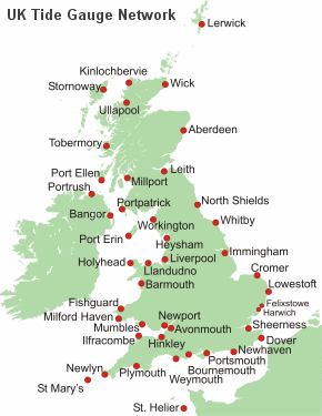 Chart datum to Ordnance datum are provided for selected UK and Irish ports - [More] Notes:For Plymouth see Devonport St. Helier (Jersey) St. Mary's (Isles of Scilly) Secondary ports and ports in Éire are not marked on the above map
|
UK highest and lowest tidal predictions for twenty years from 2006
Highest and lowest tidal predictions (XHL) between 2006-2028 are provided for locations in the UK Tide Gauge Network.Predictions include:
- Highest and lowest tidal elevations during this period
- Highest and lowest tidal elevations for each year
- Ten highest and lowest tidal elevations during this period
- Mean high water springs
- Mean high water neaps
- Mean low water neaps
- Mean low water springs