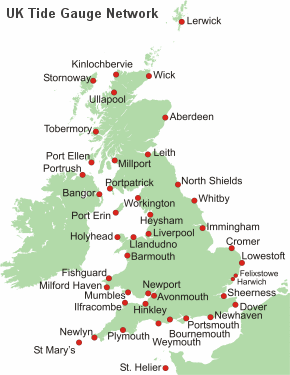
UK Tide Gauge Network
Operational Status
Further down on page ↓
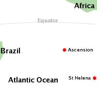
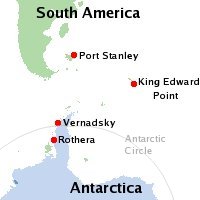
UK South Atlantic & Antarctic networkAscension
St. Helena
Falkland Islands
(Port Stanley)
South Georgia
(King Edward Point)
Rothera
Vernadsky
Gibraltar sea level station Ocean Data and Information Network for Africa (ODINAFRICA)
Staff contact details
Phil Knight
Real-time systems manager
0151 795 4811
[Webpage/Email]
Location of tide gauge Inhambane (Mozambique)

Location of tide gauge Pemba (Mozambique)
Sea level networks
UK Tide Gauge Network
About the UK networkThe UK National Tide Gauge Network, run by the Tide Gauge Inspectorate, records tidal elevations at 44 locations around the UK coast. Find out about instruments, tide gauges and systems - [More]
Operational status
This shows the latest information regarding tide gauge operations e.g. notes on gauge problems and dates of maintenance - [More]
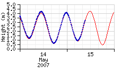
Real/Near-real time data display
Use the links below to view the latest measurements from gauges on the UK Tide Gauge Network
RT - Click red links below to view real/near real-time data from each tide gauge
ST - Click orange links below to find out about site information for each tide gauge location
XS - Click blue links below to view highest and lowest surge values for entire history of site
For Devonport use Plymouth
St. Helier (Jersey)
St. Mary's (Isles of Scilly)
Moray Firth tide gauge has now ceased operation
|
England - South Avonmouth RT | ST | XS Bournemouth RT | ST | XS Dover RT | ST | XS Hinkley RT | ST | XS Ilfracombe RT | ST | XS Newhaven RT | ST | XS Newlyn RT | ST | XS Plymouth RT | ST | XS Portsmouth RT | ST | XS St. Mary's RT | ST | XS Weymouth RT | ST | XS England - East Cromer RT | ST | XS Felixstowe RT | ST | XS Harwich RT | ST | XS Immingham RT | ST | XS Lowestoft RT | ST | XS North Shields RT | ST | XS Sheerness RT | ST | XS Whitby RT | ST | XS England - West Heysham RT | ST | XS Liverpool RT | ST | XS Workington RT | ST | XS Northern Ireland Bangor RT | ST | XS Portrush RT | ST | XS |
Scotland Aberdeen RT | ST | XS Kinlochbervie RT | ST | XS Leith RT | ST | XS Lerwick RT | ST | XS Millport RT | ST | XS Moray Firth ST | XS Port Ellen RT | ST | XS Portpatrick RT | ST | XS Stornoway RT | ST | XS Tobermory RT | ST | XS Ullapool RT | ST | XS Wick RT | ST | XS Wales Barmouth RT | ST | XS Fishguard RT | ST | XS Holyhead RT | ST | XS Llandudno RT | ST | XS Milford Haven RT | ST | XS Mumbles RT | ST | XS Newport RT | ST | XS Channel Islands St. Helier RT | ST | XS Isle of Man Port Erin RT | ST | XS |
UK South Atlantic & Antarctic network (ACCLAIM network)
|
The ACCLAIM (Antarctic Circumpolar Current Levels by Altimetry and Island Measurements) programme in the South Atlantic and Southern Oceans consists of measurements from coastal tide gauges and bottom pressure stations, together with an ongoing research programme in satellite altimetry. South Atlantic tide gauges
|
|
Antarctic tide gauges
|
|
Gibraltar sea level station
Ocean Data & Information Network for Africa (ODINAFRICA)
[ODINAFRICA - Ocean Data & Information Network for Africa]
Engineers monitoring and testing facility
Tide Gauge Inspectorate
View tabulated list of last recorded contact with tidal gauges.
Update operational status of tidal gauges.
Deep Sea Group
View your testing facility.