Printable Maps

Do you need a simple prepared map that you can print at home, at school, or in the office? Look below at our expanding list of maps formatted to be viewed, printed, or downloaded.
| Home › Printable Maps › Precipitation | ||
Printable Maps |
||
|
Do you need a simple prepared map that you can print at home, at school, or in the office? Look below at our expanding list of maps formatted to be viewed, printed, or downloaded. |
||
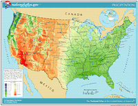
| Precipitation of the Individual States and of the Conterminous States | |||||||||||||||||||||||||
 Go to map list
 |
This colorful series of maps illustrates the average annual precipitation from 1961 through 1990. Maps were prepared for individual States and for the Conterminous States. Each color on the maps represents a range of precipitation values in inches, from just a few to nearly 200 inches. The maps are available in the following formats.
|
|
|||||||||||||||||||||||
National Atlas of the United States® and The National Atlas of the United States of America® are registered trademarks of the United States Department of the Interior Privacy Statement, Disclaimer, Accessibility, FOIA http://nationalatlas.gov/printable/precipitation.html Last modified: Tuesday April 29 2008 |
 |
|
;)
;)
;)
;)
;)
;)
;)
;)
;)
;)
;)
;)
;)
;)
;)
;)
;)
;)
;)
;)
;)
;)
;)
;)
;)
;)
;)
;)
;)
;)
;)
;)
;)
;)
;)
;)
;)
;)
;)
;)
;)
;)
;)
;)
;)
;)
;)
;)
;)