
The Oklahoma Geological Survey Observatory in rural Tulsa County, south
of Leonard is a comprehensive
geophysical observatory which records, identifies, and locates
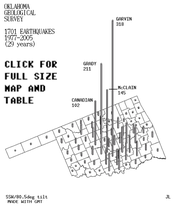
30 to 167 ![]() in
Oklahoma each year, and also records about five worldwide earthquakes
per day.
in
Oklahoma each year, and also records about five worldwide earthquakes
per day.
NORMAN STAFF  randy g keller interim director
                       ken luza norman coordinator for observatory programs

LEONARD STAFF  amie gibson seismic research specialist   918-366-4152
                        amiegibson@ou.edu

                         jake nance research specialist  918-366-4152
                         jakenance@ou.edu
REPORT FEELING AN OKLAHOMA EARTHQUAKE
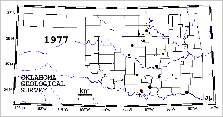
Red circle: felt earthquake. Black circle: earthquake not known to be felt. Circle diameters are proportional to the square of magnitude. Made with GMT. Projection info, GMT map and PERL catalog conversion scripts. Scroll page of individual annual maps 1977-2001.
VISITING US GENERAL INFO| VISITORS LISTS AND PHOTOS 2005-2006| 2007| 2008| EARLIER YEARS
| DAILY SEISMOGRAMS: LAST FOUR DAYS|2008|2007|2006 |2005 |2004 |2003 |2002 |2001 |2000|
| PAGES FOR SELECTED OKLAHOMA EARTHQUAKES | | SOLID EARTH TIDES |
Earthquake ground motion maps for IBC2000, IBC2003, and certain other building codes.
Main OGS website at Norman Oklahoma
Azimuthal equidistant map of the earth centered on Leonard, showing 17656 epicenters
SEISMOGRAMS, spectrograms, and selected magnetograms
Map of Oklahoma Seismograph Stations
Oklahoma Geology, Oklahoma crustal models, Leonard sedimentary sections, and boreholes
NUCLEAR EXPLOSION CATALOG
OGS Seismic website access statistics
Steve Malone's Seismosurfing-lists all seismology/earthquake sites in the world
Loglinear graph paper template
Publications
OGS
Staff
Oklahoma Geological Survey
100 E. Boyd, Rm. N-131
Norman, OK 73019-0628
405/325-3031; 800/330-3996; fax 405/325-7069
OGS Publication Sales
1218-B W. Rock Creek Road
gLinera
Norman, OK 73069-8590
405/360-2886
e-mail: ogssales@ou.edu
Oklahoma Geological Survey Observatory
Number One Observatory Lane, Post Box 8
Leonard, OK 74043
918/366-4152; fax 918/366-4156
e-mail: amiegibson@ou.edu