U.S. Geological Survey
First in the 2002 "Science, Society, Solutions" series
Everyone is welcome to attend this briefing. Presentations will illustrate that, by working with partners, we will provide the Nation with access to current, accurate, and nationally consistent digital data and topographic maps derived from those data.
Other Science, Society, Solutions Briefings
| Thursday, April 11, 2002 10:00 a.m. - 11:00 a.m. Rayburn Building Room 2318 Washington, DC Refreshments will be served |
Speakers: (Speaker Biographies) Barbara Ryan U.S. Geological Survey Bryan Logan Earth Data Holdings Hugh Bender Texas Natural Resources, Information System Andria Ruben Keyhole Corporation |
| Hosted by: The following links leave the USGS site. The American Society for Photogrammetry & Remote Sensing | Congressional Sponsors: The following links leave the USGS site. Representative Tom Davis (VA) Representative Lloyd Doggett (TX) Representative Paul Kanjorski (PA) Representative Connie Morella (MD) |
Directions to Rayburn House Office Building:
East on Rt.66 over the Roosevelt Bridge; right on Independence Avenue. Follow Independence past the construction of the Botanic Gardens; right on Canal Street (2 blocks); left on D Street. Pay parking is on the right between D Street and Canal Street.
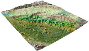
Geographic information underpins an increasingly large part of the Nation´s economy. Governments, the private sector, and nongovernmental organizations depend on a common set of nationally consistent, accurate, and up-to-date base information that describes the American landscape and locates features. Learn how, a seamless, continuously maintained foundation of geographic data being developed by the USGS, is an important tool for economic and community development, land and natural resource management, and health and safety services including homeland security.
 |
Barbara Ryan
Barbara J. Ryan is the Associate Director for Geography at the U.S. Geological Survey (USGS). In this capacity, she has program and policy oversight responsibilities for the Nation´s largest civilian mapping organization. During her 27-year career with the USGS, she has worked in seven States and Washington, D.C. From 1989 to 1991, she served as Staff Assistant to the Assistant Secretary for Water and Science at the Department of the Interior. Before becoming Associate Director for Geography, she served as the agency´vs Chief Information Officer. She holds a Bachelor´s degree in Geology from the State University of New York at Cortland, a Master´s degree in Geography from the University of Denver, and a Master´s degree in Civil Engineering from Stanford University. She resides, with her husband and son, in Oakton, Virginia
Bryan Logan
Bryan Logan is Chairman and CEO of the EarthData group, which consists of 12 wholly owned or affiliated companies involved in all aspects of airborne sensing, ground surveying, photogrammetric mapping, GIS development, technical training and consulting. The EarthData group carries out projects throughout the 50 United States, Central and South America, Europe and the Middle East. Bryan attended engineering college in his place of birth - Coleraine, Northern Ireland - where he joined the BKS group of surveying and mapping companies as a cartographer, then rising through the organization to the position of Managing Director (President). During his tenure at BKS, he managed surveying, mapping and GIS projects in Europe, the Middle East, Far East, Africa and the Americas. Bryan purchased the founding company of the EarthData group (Photo Science, Inc.) in 1985 and under his leadership the EarthData group has moved to the forefront of the airborne remote sensing, mapping and GIS industry - undertaking projects around the world.
Hugh Bender
Hugh has over 17 years experience as a Community and Regional Planner, specializing in Geographic Information System application development. His resume includes work for the President of the St. Louis Board of Alderman; at the City of Austin - Planning and Growth Management Department; in the private Sector with Harland Bartholomew & Associates, and 10 years with the City of Round Rock Planning Department as Assistant Director of Planning. Mr. Bender has been active in Texas local, regional and state GIS applications and coordination for over a decade. Mr. Bender became Director of TNRIS, a Division of the Texas Water Development Board (TWDB), in 1997 overseeing the Information Distribution Services, Borderland Information Center, Research and Development Center and Strategic Mapping (StratMap) Sections of TNRIS. Mr. Bender is a member of the EROS Data Center National Archive Advisory Committee for satellite imagery, a steering committee member for FEMA´s Project Impact in Austin and a steering committee member for the TxDOT STARS (State Traffic and Reporting System). TNRIS is actively participating in the National Map pilot with the USGS and numerous other agencies.
Andria Ruben
Andria R. Ruben is Director of Government Relations for Keyhole Corp, a California Company that is redefining how people look at the world with a new 3D model of the earth, a "digital earth", that streams terabytes of earth-information across the Internet to regular PC´s. Prior to joining Keyhole Corp. Ms. Ruben was Vice President of Operations for Intrinsic Graphics, developer of the Intrinsic Alchemy 3D graphics software platform. She served as acting CFO of GigaPixel Corporation, developer of 3D graphics SoC ASIC designs and of CompCore Multimedia, developer of digital audio and video encoding and decoding hardware and software designs. Ms. Ruben earned her B.A. in Political Science and an M.B.A. from the University of California at Irvine.
For more information about National Map and activities, please contact Barbara Ryan.
For more information about this topic or the briefing series, please contact the USGS Office of Communications.

![]() U.S. Department of the Interior |
U.S. Geological Survey
U.S. Department of the Interior |
U.S. Geological Survey
URL: http://www.usgs.gov/solutions/national_map.html
Page Contact Information:
Ask USGS
Page Last Modified: 21-Feb-2003@15:08
