to the National Atlas Home page
About | Contact Us | Partners | Products | Site Map | FAQ | Help 
AgricultureBiologyBoundariesClimateEnvironmentGeologyGovernmentHistoryMappingPeopleTransportationWater
to the Interactive Map MakerMap LayersPrintable MapsWall MapsDynamic MapsArticlesMapping Professionals
 

Dynamic Maps

 
  Dynamic Map Icon
Nationalatlas.gov™ contains a remarkable range of products and services to meet the diverse needs of people who are looking for maps and geographic information about America. Dynamic maps are innovative illustrations of geographic phenomena. We combine the science of mapping with today's multimedia to offer maps that are useful, understandable, and that stimulate interactivity.
 
     
  Zebra Mussels
 
Link to Zebra mussels dynamic map. View dynamic Map.

Directions -
Click the small map to the left to view the dynamic map.  A new window will open containing the Zebra Mussels dynamic map.  To explore this map, move your cursor over year tabs
or the loop button. loop button 

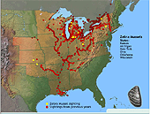
Zebra mussel sighting locations are represented by yellow and red markers on this map. States where zebra mussels have been found in inland and adjacent waters are identified by an orange tint.  Moving the cursor back and forth over the year indicators on the control bar allows you to view the spread of this invasive species backward and forward in time.  Moving over the loop arrow will make the dynamic map continuously loop to show the geographic progression of zebra mussels over time. Looping may be paused by moving the cursor over a specific year tab.

Moving the cursor over an orange colored State will display State names at the bottom of the map.

Biology
Map Maker
Invasive Species:  Zebra Mussel Distribution
Map Layer
Articles
Zebra Mussels
Dynamic Map
Invasive Species - Zebra Mussels
 
 
Detailed Information -
For more detailed information about Zebra Mussels go to the Invasive Species - Zebra Mussels article or to a related link below.
Related Links

back to top