| Home › Dynamic Maps | ||||
Dynamic Maps |
||||
Dynamic Maps |
||||
| |
||||
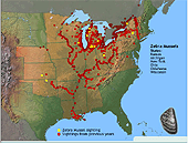
| Invasive Species - Zebra Mussel Distribution - Dynamic Map | |||||||||||||||
|
This dynamic map shows: The spread of zebra mussels in the United States between the years 1988 and 2002. Zebra mussels have spread throughout waterways in the eastern and midwestern states. |
|
|||||||||||||
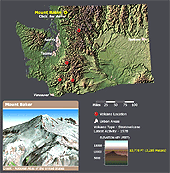
| Volcanoes - Dynamic Map | |||||||||||||||
|
Explore America's potentially active volcanoes with six dynamic maps.
|
|
|||||||||||||
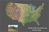
| Shaded Relief- Dynamic Map | |||||||||||||||
|
This is a map of the conterminous United States that combines a depiction of terrain relief with tinted elevation ranges.
|
|
|||||||||||||
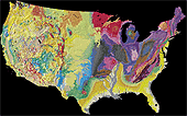
| Tapestry of Time and Terrain - Dynamic Maps | |||||||||||||||
|
What's been happening in the lower 48 States in the last 2.6 billion years?! Discover this unique combination of geologic and topographic maps and explore American landscapes and the agents that shaped them. Plug-ins required: QuickTime
|
|
|||||||||||||
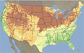
| Vegetation Growth in the United States - Dynamic Map | |||||||||||||||
|
Watch a series of satellite images that illustrate vegetation growth and vigor in Alaska and the lower 48 United States in 2004.
|
|
|||||||||||||
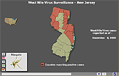
| West Nile Virus 2000 - Dynamic Map | |||||||||||||||
|
These maps and charts illustrate documented occurrences of West Nile Virus between May 13, 2000 and December 8, 2000. Let your cursor roam over the maps and images.
|
|
|||||||||||||
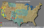
| Wildlife Mortality - Avian Cholera | |||||||||||||||
|
Track known occurrences of avian cholera over the past 50 years using this dynamic map. Interesting articles on wildlife health are only a click away too.
|
|
|||||||||||||
National Atlas of the United States® and The National Atlas of the United States of America® are registered trademarks of the United States Department of the Interior Privacy Statement, Disclaimer, Accessibility, FOIA http://www.nationalatlas.gov/dynamic.html Last modified: April 29, 2008 14:54 |
 |
|