Recreational Activities:
- Auto Touring
- Biking
- Boating
- Camping
- Climbing
- Fishing
- Hiking
- Horseback Riding
- Hunting
- Interpretive Programs
- Off Highway Vehicle
- Picnicking
- Recreational Vehicles
- Visitor Center
- Wildlife Viewing
- Winter Sports
Find Recreation Areas |
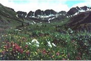
Alpine TriangleDescriptionThe Bureau of Land Management cares for 600,000 acres of public land in the upper Gunnison River basin in southwest Colorado. Collaborating with a number of public and private partners, we guide the protection, management, and sustainable use of a wide variety of resources. Ecosystems within the GRA range from dry sagebrush steppes at 7,000 ft.; to forests of aspen, ponderosa pine, Douglas fir, lodgepole pine, Engleman spruce, and subalpine fir; to alpine tundra meadows that reach to over 14,000 ft.
Recreational Activities:
Directions:The Silverton and Ouray entrances to the Loop can be accessed via U.S. Highway 550 south of Montrose or north of Durango. The Lake City entrances are accessed via State Highway 149 south of Gunnison or north of Creede.Additional Information:Alpine Triangle Web SiteWeather Information:Weekly National Weather Service Forecast for Gunnison,COThere is no live information from National Weather Service |
 |

