
THIS DYNAMIC PLANET: A TEACHING COMPANION
Brief Overview of Plate Tectonics
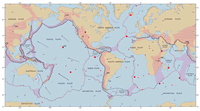
Since ancient times, the name Terra Firma (meaning "solid ground" in Latin) sometimes has been and occasionally still is used for planet Earth. While our planet is for the most part "solid" and firm, its outermost layer is everywhere in ceaseless motion, shifting at measurable average rates of several centimeters per year. This ever–moving layer upon which we live is a thin skin of solid crust and the rigid uppermost mantle making up Earth's lithosphere. The lithosphere is broken up into slabs that geologists call lithospheric plates or tectonic plates. During the 20th century, a major scientific concept—Theory of Plate Tectonics—emerged to explain why and how these plates move about and interact (see Plate Tectonics in a Nutshell). This theory has unified the study of the Earth and proven to be as relevant to the earth sciences as was the discovery of the structure of the atom to physics and chemistry, and as was the theory of evolution to the life sciences. Even though the plate tectonics theory is now widely accepted by the scientific community, some aspects of it are still being vigorously debated today.
This Dynamic Planet Map and This Dynamic Earth Booklet
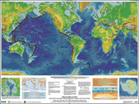
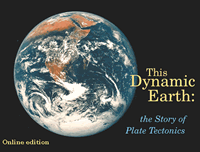
In June 2006, the U.S. Geological Survey (USGS) and the Smithsonian Institution produced the Third Edition of This Dynamic Planet: A World Map of Volcanoes, Earthquakes, and Plate Tectonics. Like its two previous editions (1989 and 1994), this map—the all–time best–selling map of the USGS–remains exceptionally popular and widely distributed. Yet, despite the availability of this map, specifically intended for educational purposes, numerous and continued requests have been received from teachers for classroom materials that expand on the map's explanatory text. In response, a general–interest, non–jargon booklet called This Dynamic Earth: The Story of Plate Tectonics was published in 1996 to complement the map. This booklet partially filled the need, but additional classroom–specific activities and exercises are still being requested.
The Development of This Dynamic Planet: A Teaching Companion
The educators' continuing requests spurred an intermittent effort, which began in the 1990s, to develop a collection of classroom exercises—A Teaching Companion—specifically geared to the existing USGS plate tectonics map and booklet. This Teaching Companion is intended to assist teachers to teach plate tectonics, primarily for grades 6–14. Through several workshops held during 1990s at the USGS Menlo Park Center, dozens of teachers from across the country worked together, not only with authors of both the map and booklet but also other USGS experts, in developing classroom activities.
The Launch of the First This Dynamic Planet: A Teaching Companion Exercises
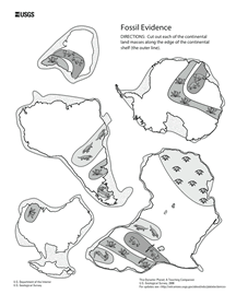
The original plan of the USGS was to publish A Teaching Companion in both web and hardcopy versions. However, recent budgetary cuts and restructuring has precluded–for the foreseeable future–the hardcopy format because of the high costs of editing, printing, and storage and distribution. As a fallback, the USGS now intends to make available to teachers web versions of the classroom exercises as they are completed. The first of these is here released electronically as Wegener's Puzzling Evidence. This activity is based on Alfred Wegener's pioneering studies that demonstrated that the scattered distribution of certain fossil plants and animals on present–day, widely separated continents would form coherent patterns if the continents are rejoined as the pre–existing supercontinent Gondwanaland (web link to booklet).
The "Wegener's Puzzling Evidence" activity was selected to be released first because of its historical significance in the development of the Theory of Plate Tectonics. While the notion that continents may have not always been fixed in their present positions was suspected long before Wegener's time. Early map makers, for example Abraham Ortelius, noted as early as the late 16th century the similarity of the coastlines of the American and African continents and speculated that these continents might have once been joined. However, Wegener's analysis was the first to use geological and fossil evidence rather than merely fitting similar–looking coastlines.
The next classroom activities will be posted here when they are ready.
